
Tree belts, hedges and grass
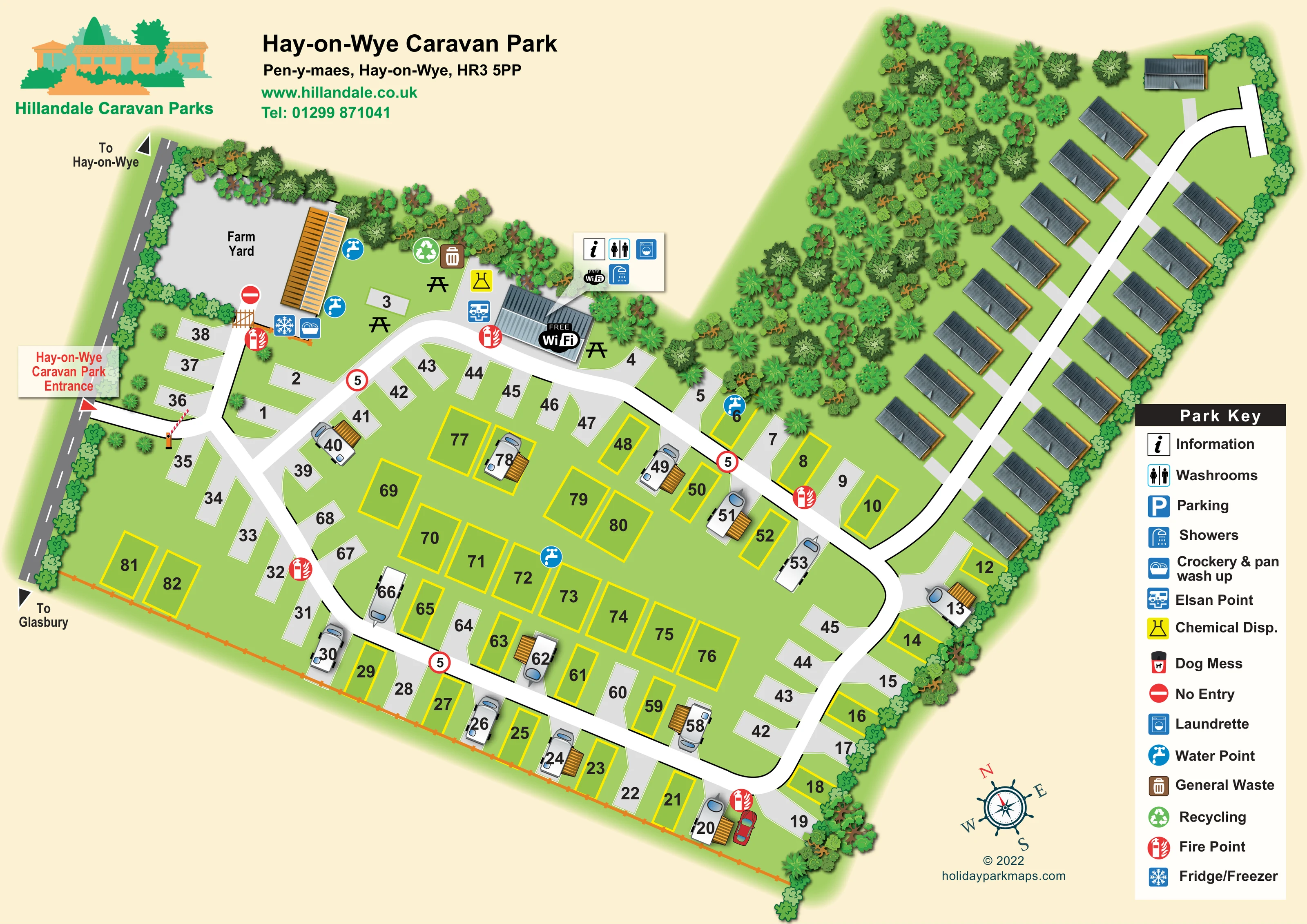
Dense illustrated trees separate the holiday-home avenue from the touring pitches. Hedges and trees line much of the perimeter, while grass fills the accommodation areas.
ILLUSTRATED PARK MAP · P157
Pen-y-maes, Hay-on-Wye · United Kingdom
 Enlarge the map ↗
A SENSE OF THE PLACE
Hay-on-Wye Caravan Park offers holiday home pitches, touring and camping close to the town known for its bookshops and literary festival. Level grass and hardstanding spaces provide a choice of pitch styles.
Electric connections, washrooms and Wi-Fi support stays. The park welcomes dogs, and its location suits walking, cycling and outings around the River Wye as well as visits to Hay's shops, galleries and cafés.
LOOK CLOSER
Dense illustrated trees separate the holiday-home avenue from the touring pitches. Hedges and trees line much of the perimeter, while grass fills the accommodation areas.
A grey area labelled Farm Yard sits beside the entrance-side buildings, separated from the public accommodation routes by a marked no-entry access.
An orange post-and-rail fence runs along the lower edge of the main accommodation area.
An information symbol appears in the facility callout beside the central service building.
The service-building callout groups washroom, shower and washing-machine symbols, identified by the Park Key.
Wash-up and fridge/freezer symbols are positioned beside the long building near the farm yard.
Separate Elsan and chemical-disposal symbols appear immediately to the left of the central service building.
Blue tap symbols identify several water points near the service area and among the pitches.
An information symbol appears in the facility callout beside the central service building.
The service-building callout groups washroom, shower and washing-machine symbols, identified by the Park Key.
Wash-up and fridge/freezer symbols are positioned beside the long building near the farm yard.
Separate Elsan and chemical-disposal symbols appear immediately to the left of the central service building.
Blue tap symbols identify several water points near the service area and among the pitches.
General-waste and recycling symbols are grouped on the upper edge of the main pitch area, beside the tree belt.
Repeated red fire-point symbols are distributed around the touring area and near the service buildings.
Free Wi-Fi badges are shown on the central service building and in its facility callout.
Black picnic-table silhouettes appear on the grass around the service area.
Parking is listed in the Park Key, but a corresponding marked parking location is not clearly visible in the plan.
A dog-waste symbol is included in the Park Key; no corresponding location is clearly identifiable in the artwork.
Dense illustrated trees separate the holiday-home avenue from the touring pitches. Hedges and trees line much of the perimeter, while grass fills the accommodation areas.
A grey area labelled Farm Yard sits beside the entrance-side buildings, separated from the public accommodation routes by a marked no-entry access.
The entrance is labelled on the left-hand road, with directional arrows towards Hay-on-Wye and Glasbury.
A white road loop serves the main pitches and connects to a long holiday-home access avenue. A barrier marks the arrival route, a no-entry symbol marks the farm-yard approach, and red-ringed signs displaying 5 appear around the main circulation route.
An orange post-and-rail fence runs along the lower edge of the main accommodation area.
READING THE MAP
This illustrated map of Hay-on-Wye Caravan Park presents two contrasting accommodation areas within one clear visitor plan. A broad network of numbered touring pitches fills the main part of the site, while a separate avenue of static holiday homes stretches towards the upper right. Dense trees between the two areas make that division immediately visible, and hedges, grass and an orange boundary fence give the layout a distinctly green setting.
The entrance is shown beside the road linking towards Hay-on-Wye and Glasbury. From there, wide white roads guide the eye past the farm yard and service buildings into the pitch network. Large plot numbers support everyday navigation, while coloured symbols identify practical facilities including water points, wash-up provision, chemical disposal, laundry and fire points.
The design combines a straightforward overhead plan with pictorial roofs, vehicles and richly drawn trees. Hillandale branding and park contact details sit above the map, and a substantial right-hand key keeps the accommodation area free of lengthy facility labels. It is a useful example of mapping a mixed caravan park without losing the character of its individual sections.
The plan is arranged diagonally across a cream landscape page. Its main touring area forms a broad lower section, with pitches following the perimeter road and additional rows occupying the ground inside the loop. Pale grey pitch shapes alternate with grass-coloured plots outlined in yellow. Both carry prominent black numbers, although the key does not define the distinction between these treatments. Selected plots include illustrated touring vehicles and orange deck-like details.
At the left, a labelled entrance branches from the adjacent road through a drawn barrier. Direction arrows point towards Hay-on-Wye and Glasbury. The nearby Farm Yard is a separate grey space, with a no-entry symbol at its approach. Two elongated buildings sit along this entrance-side edge: an orange-roofed structure beside wash-up and fridge/freezer symbols, and a grey-roofed service building accompanied by a compact facility callout. That callout identifies information, washrooms, showers, laundry and Wi-Fi. Elsan and chemical-disposal symbols sit nearby, together with picnic tables and waste and recycling points.
The main road continues around the touring pitches and connects to a narrower upper-right arm. Here, dark-roofed holiday homes stand on both sides of a straight access avenue, linked by short grey approaches. Dense, varied tree canopies form a substantial buffer between this avenue and the main pitch area. Hedges enclose the outer edge, while an orange fence follows the lower boundary.
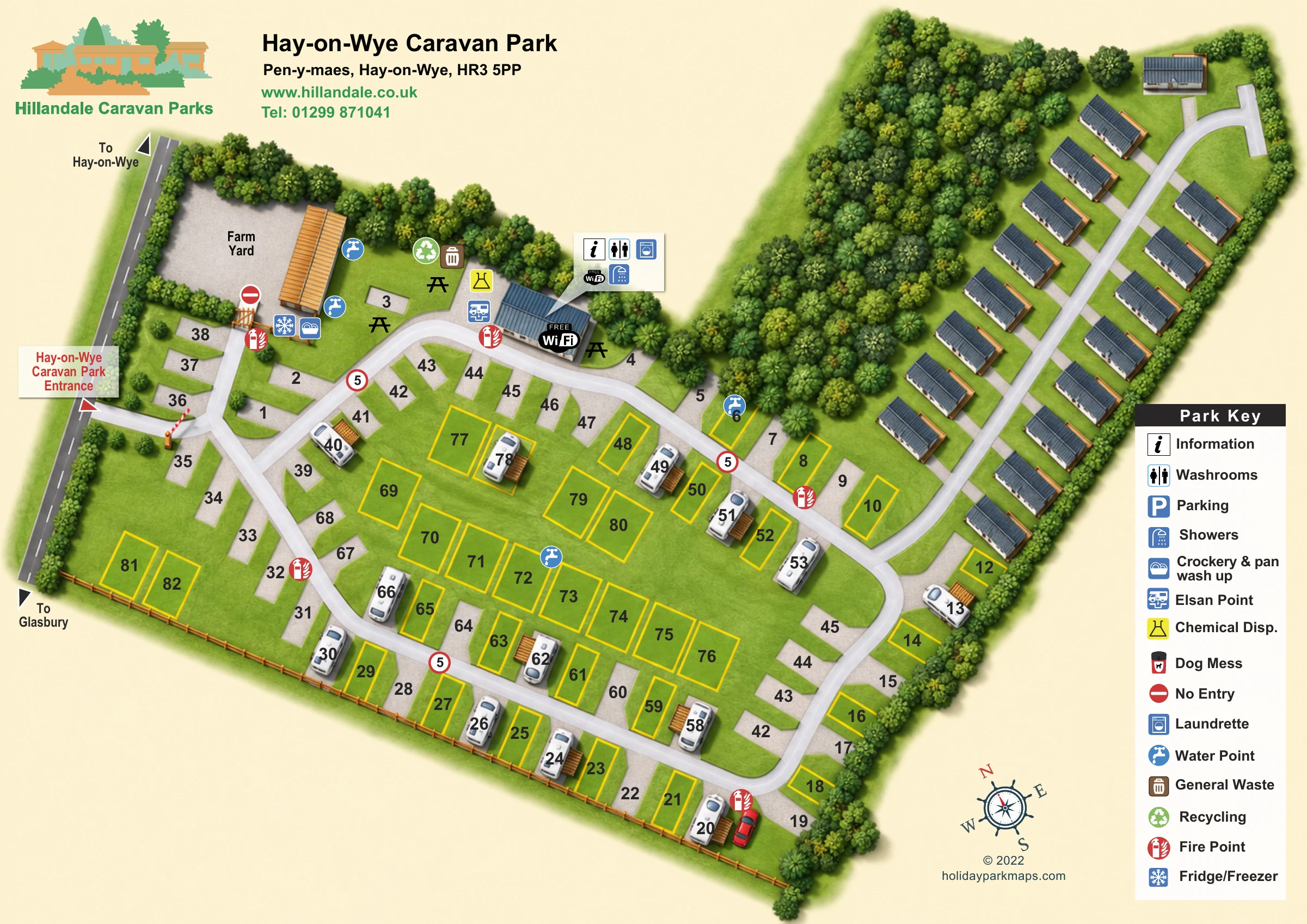
Repeated tap and fire-point symbols distribute essential wayfinding information across the plan. A tall Park Key occupies the right margin, and a decorative compass sits below the accommodation area. The accompanying detail view enlarges this same key and adjoining pitches; it is not a separate section map.
 Enlarge this map ↗
KEEP EXPLORING
Chosen for shared landscapes, accommodation or facilities.
 Explore the map ↗
United Kingdom
Ashby Park map with seven fishing lakes, colour-coded accommodation and illustrated wooded shorelines.
 Explore the map ↗
United Kingdom
Woodland-framed Barnsoul map with mixed accommodation, shared facilities and paw-marked walking routes.
 Explore the map ↗
United Kingdom
Colour-coded park map with numbered holiday-home areas, touring pitches, camping and an illustrated leisure hub.
Features may come from the sample artwork, its key or published park information. Approximate numbers describe the drawing and may cover only part of a park. They are intended to help you compare map examples. Current facilities and booking information should be checked with the park.
LET’S MAP YOUR PARK
For a map quotation, find your park and draw a rough boundary around it. The area you select helps us work out the design time and price.
Draw your park for a quote ↗Or talk to our map designers
01751 473136