
Named fields and lettered sections
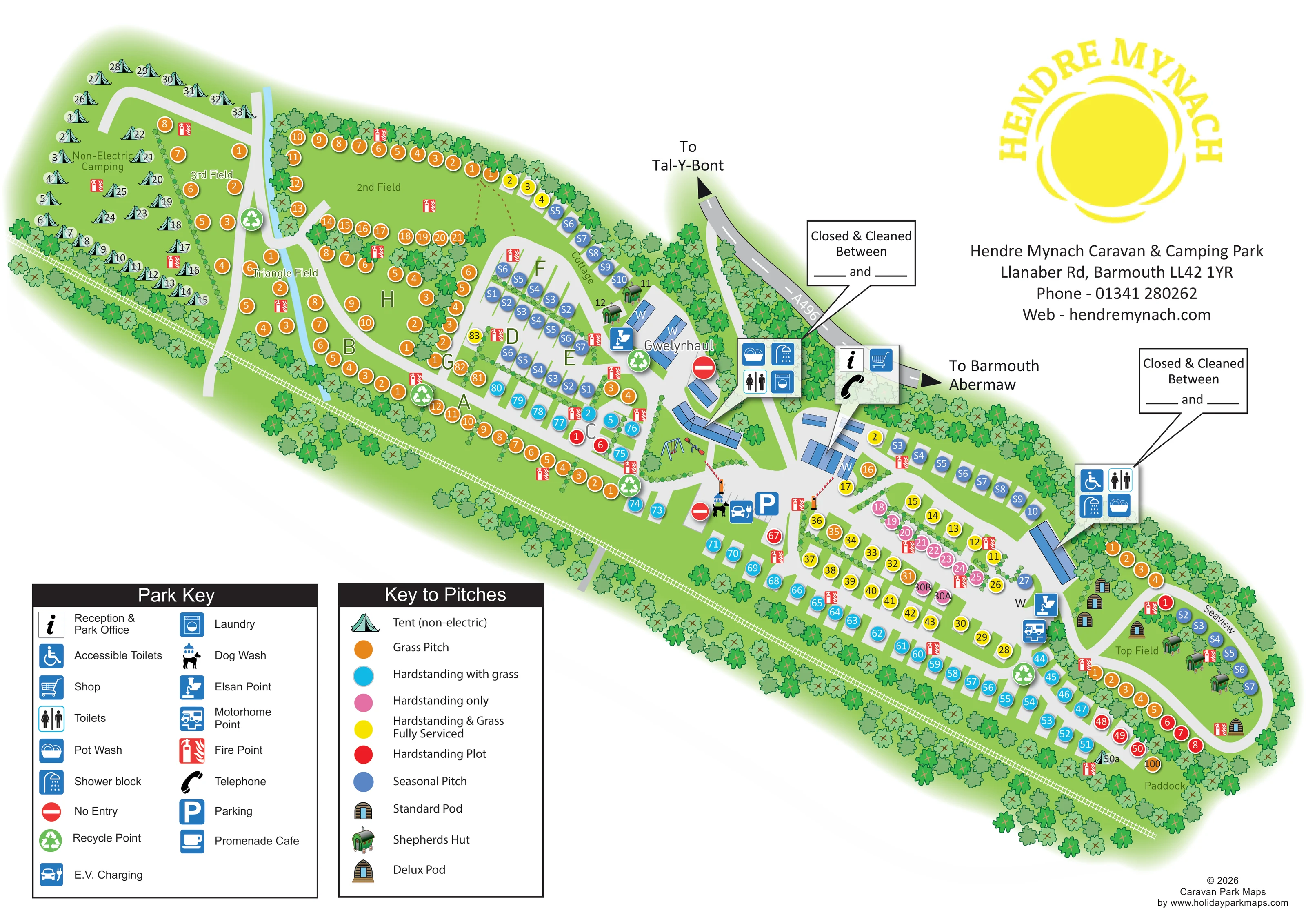
Non-Electric Camping, 3rd Field, 2nd Field, Triangle Field, Top Field and Paddock sit alongside large lettered accommodation sections.
ILLUSTRATED PARK MAP · P162
Hendre Mynach Caravan & Camping Park, Llanaber Rd, Barmouth · United Kingdom
 Enlarge the map ↗
A SENSE OF THE PLACE
Hendre Mynach provides camping, touring and rental accommodation near Barmouth. Caravans, pods, shepherd's huts and a holiday house offer alternatives to bringing camping equipment.
A shop, children's play area, accessible washrooms and dog-washing facilities support a coastal stay. A footpath leads towards the beach via a pedestrian railway crossing, and the town and surrounding coast provide further places to explore.
LOOK CLOSER
Non-Electric Camping, 3rd Field, 2nd Field, Triangle Field, Top Field and Paddock sit alongside large lettered accommodation sections.
Dense stylised trees enclose much of the park, with smaller planted lines dividing pitch groups.
Information and shopping symbols locate the arrival facilities beside the A496 approach.
Grouped facility callouts identify washroom provision at the central buildings and farther east, including accessible-toilet symbols.
Pot-wash symbols are included in the washroom facility groups.
A washing-machine symbol locates laundry provision within the central facility group.
A distinctive dog-and-shower illustration marks the dog wash beside the parking and charging area.
The car-and-plug symbol appears beside the central parking area.
Information and shopping symbols locate the arrival facilities beside the A496 approach.
Grouped facility callouts identify washroom provision at the central buildings and farther east, including accessible-toilet symbols.
Pot-wash symbols are included in the washroom facility groups.
A washing-machine symbol locates laundry provision within the central facility group.
A distinctive dog-and-shower illustration marks the dog wash beside the parking and charging area.
The car-and-plug symbol appears beside the central parking area.
A blue P identifies parking close to the central junction and barrier-controlled routes.
Disposal symbols occur near the central buildings and eastern touring area.
A motorhome service symbol is positioned near the eastern facilities and pitch roads.
Illustrated swings and a seesaw occupy a small green beside the central buildings.
A black handset symbol appears beside the reception and shop callout.
Repeated red fire-point symbols are distributed throughout the accommodation areas.
Large green recycling symbols mark several points along the internal road network.
Listed in the Park Key; no corresponding position is clearly identifiable in the depicted plan.
Non-Electric Camping, 3rd Field, 2nd Field, Triangle Field, Top Field and Paddock sit alongside large lettered accommodation sections.
Dense stylised trees enclose much of the park, with smaller planted lines dividing pitch groups.
A continuous white rail-and-sleeper line follows the lower edge of the long site.
A grey path extends from the central park roads across the illustrated railway boundary.
Park information describes a footpath towards the beach via a pedestrian railway crossing; the beach itself is outside this artwork.
The approach road is labelled A496, with arrows towards Tal-Y-Bont and Barmouth/Abermaw.
Red-and-white barrier arms and no-entry symbols clarify selected movements around the central arrival roads.
READING THE MAP
This illustrated map of Hendre Mynach Caravan & Camping Park presents a long, varied site near Barmouth as a clear sequence of fields, pitch rows and shared facilities. The railway runs along one edge of the plan, while the A496 approach and arrows towards Tal-Y-Bont and Barmouth/Abermaw establish the local road connections. A large yellow sun logo gives the page a recognisable park identity.
The accommodation mix is central to the design. Coloured numbered circles distinguish grass pitches, several hardstanding options, fully serviced pitches and seasonal use. Tent illustrations identify the non-electric camping area, while small drawings of pods and shepherd's huts make the glamping provision easy to recognise. Named fields and large section letters add another layer of orientation.
The map also brings together reception, shop, washrooms, laundry, play equipment, dog washing and touring service points. Two separate keys keep this information organised without crowding the accommodation areas. It is a useful sample for a coastal touring and camping park needing to explain varied pitch types across an unusually elongated layout.
The single landscape-format plan places Hendre Mynach diagonally across the page, with its western camping fields at upper left and Top Field and the Paddock towards the lower right. A pale-grey road network links the accommodation areas, branching from the central arrival facilities beside the A496. Direction arrows point towards Tal-Y-Bont and Barmouth/Abermaw, while illustrated barriers and no-entry markers distinguish selected vehicle movements around the central junction.
At the western end, numbered tent illustrations sit within the labelled Non-Electric Camping area. Nearby, 3rd Field, 2nd Field and Triangle Field contain orange grass-pitch markers. Large letters identify further central sections, where grass pitches meet rows of blue seasonal markers. Farther east, cyan, yellow, pink and red circles distinguish different hardstanding and serviced options. Small pod and shepherd's-hut illustrations provide a contrasting accommodation language around Top Field and near the central buildings. Cottage and Gwelyrhaul are also named on the plan.
Blue-roofed buildings and enlarged symbol panels identify reception and the shop, toilets, showers, accessible toilets, pot washing and laundry. The central green includes swings and a seesaw. Parking, EV charging and a distinctive dog-wash illustration sit nearby, with Elsan and motorhome service symbols elsewhere along the roads. Repeated fire-point and recycling markers distribute practical information throughout the park.
Tree belts enclose the site and divide pitch groups. A white railway line follows the lower boundary, crossed by a grey path near the centre. The lower-left corner holds separate facility and pitch keys; the upper-right white space accommodates the sun logo and contact details. The detail enlargements show these same keys and central features rather than additional map sections.
KEEP EXPLORING
Chosen for shared landscapes, accommodation or facilities.
 Explore the map ↗
United Kingdom
Coastal park plan with colour-coded pitches, named neighbourhoods and a Morecambe Bay walking route.
 Explore the map ↗
United Kingdom
A colour-zoned coastal park map with touring areas, woodland trails, ponds and a leisure club.
 Explore the map ↗
United Kingdom
Illustrated mixed-accommodation park plan with colour-coded caravans, named eco units and a touring loop.
Features may come from the sample artwork, its key or published park information. Approximate numbers describe the drawing and may cover only part of a park. They are intended to help you compare map examples. Current facilities and booking information should be checked with the park.
TAKE A CLOSER LOOK
View the illustrated map in detail or choose a file to download. These are sample maps; contact the park for current visitor information.


LET’S MAP YOUR PARK
For a map quotation, find your park and draw a rough boundary around it. The area you select helps us work out the design time and price.
Draw your park for a quote ↗Or talk to our map designers
01751 473136