
Tree-lined watercourse
An unnamed pale-blue watercourse curves around the northern and western edges of the park, framed by dense rows of trees.
ILLUSTRATED PARK MAP · P495
Henstent Park, Llangynog, near Bala, Powys · United Kingdom
 Enlarge the map ↗
A SENSE OF THE PLACE
Henstent Holiday Park is a small countryside park at Llangynog, with views across the Tanat Valley and towards the Berwyn Mountains. Its layout is designed to make use of the panoramic setting.
Holiday home pitches are fronted by dry-stone walls, with surfaced roads and low-level lighting through the grounds. Wi-Fi is available, and the map provides an overview of the plots and access routes.
LOOK CLOSER
An unnamed pale-blue watercourse curves around the northern and western edges of the park, framed by dense rows of trees.
Continuous perimeter trees, scattered internal trees and small flower beds distinguish boundaries and soften the buildings and road junctions.
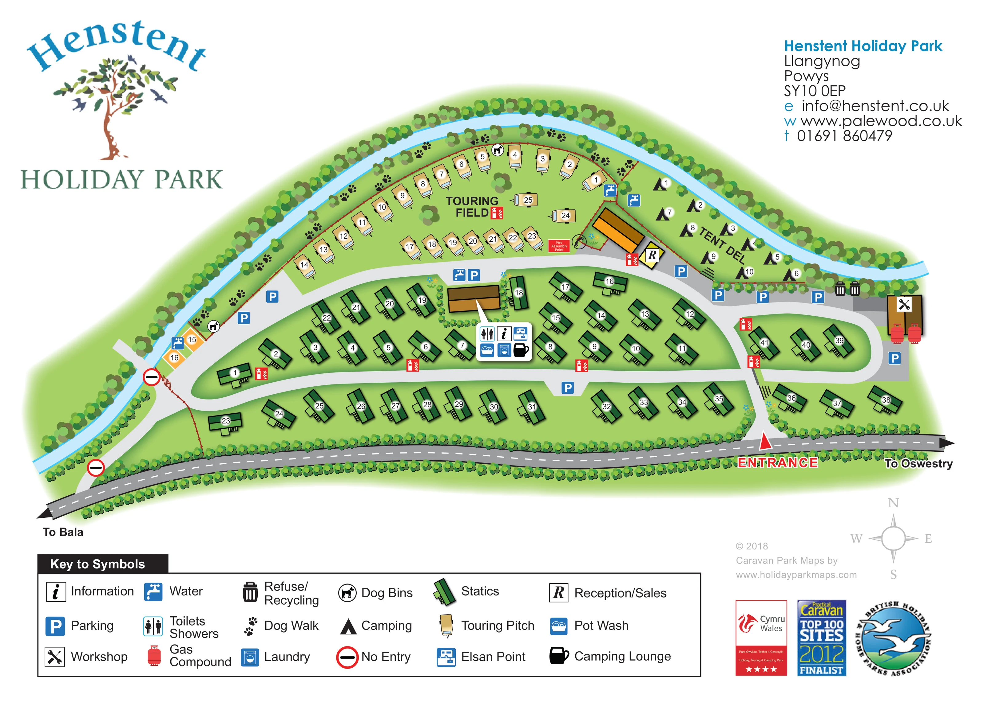
An R marker identifies the reception/sales building beside the upper internal road, between the touring and camping areas.
A brown-roofed building within the static-caravan area is accompanied by a grouped panel of service symbols.
The combined toilets/showers symbol appears in the central amenity panel.
An information symbol is included in the central amenity panel.
A blue washing-machine symbol locates laundry facilities at the central amenity building.
The blue pot-wash symbol is grouped with the central services.
An R marker identifies the reception/sales building beside the upper internal road, between the touring and camping areas.
A brown-roofed building within the static-caravan area is accompanied by a grouped panel of service symbols.
The combined toilets/showers symbol appears in the central amenity panel.
An information symbol is included in the central amenity panel.
A blue washing-machine symbol locates laundry facilities at the central amenity building.
The blue pot-wash symbol is grouped with the central services.
A black mug symbol identifies the camping lounge in the central amenity cluster.
Chemical toilet disposal is indicated by the Elsan symbol in the central amenity panel.
Blue tap symbols are distributed around the touring and camping areas and beside the upper internal road.
Blue P markers identify several parking locations along the internal roads, including beside reception and the eastern service area.
Paired bin symbols appear beside the road near the eastern end of the camping area.
The eastern service corner contains a workshop symbol on a small building and red gas-cylinder symbols alongside it.
Repeated paw prints mark a riverside walking strip along the upper boundary, with dog-bin symbols at points on the route.
A labelled fire assembly point is shown beside reception; red fire-equipment pictograms recur around the accommodation roads.
An unnamed pale-blue watercourse curves around the northern and western edges of the park, framed by dense rows of trees.
Continuous perimeter trees, scattered internal trees and small flower beds distinguish boundaries and soften the buildings and road junctions.
A red triangle and large Entrance label mark access from the roadside at the lower right of the plan.
Broad light-grey roads connect the entrance, accommodation rows, reception and service areas, with curved ends and connecting junctions.
The darker public road along the lower boundary carries arrows towards Bala on the left and Oswestry on the right.
Two red-ringed no-entry symbols mark the western road and watercourse crossing area.
The catalogue describes countryside views across the Tanat Valley towards the Berwyn Mountains; these wider views are not illustrated as a panorama on the plan.
READING THE MAP
This illustrated map of Henstent Holiday Park presents a compact countryside site at Llangynog, near Bala in Powys. A pale-blue watercourse curves around the grounds, while tree belts define the park’s edges and separate it from the public road. Within that frame, the artwork clearly distinguishes green static caravans, cream touring units and a separate camping area labelled Tent Del.
The plan combines accommodation finding with everyday visitor orientation. Numbered units sit beside broad grey access roads, the main entrance is picked out in red, and roadside arrows show the directions towards Bala and Oswestry. Reception, parking, water points and a central amenity building are supported by a substantial symbol key beneath the illustration.
The riverside dog walk is an especially recognisable part of the design, using repeated paw prints rather than a conventional path line. Large park branding and generous white space surround the practical plan. As a gallery example, it shows how a mixed holiday park can bring accommodation, visitor services and a distinctive natural boundary together on one readable sheet.
The main plan follows the park’s elongated shape between a tree-lined watercourse and the public road. The entrance sits towards the lower right, where a red triangle leads visitors onto the internal road network. Light-grey routes run through the static-caravan area and connect with the upper road serving reception, touring and camping. Darker road colouring, a dashed centre line and outward-pointing arrows distinguish the external route towards Bala and Oswestry.
Green static-caravan illustrations occupy most of the lower grounds. Their staggered arrangement follows the roads, with individual white number badges positioned over the roofs. Above them, the Touring Field uses cream caravan icons in a curved perimeter row and a shorter inner grouping. The adjacent Tent Del area uses numbered black tent symbols, keeping camping visually separate from touring accommodation.
Reception/sales is marked beside an ochre-roofed building at the meeting point of these upper areas. A second, brown-roofed building near the centre carries a grouped amenity panel for toilets and showers, information, laundry, pot wash, an Elsan point and the camping lounge. Parking and water symbols are distributed around the roads. Refuse/recycling, a workshop and the gas compound appear towards the eastern end, while fire-equipment markers and a labelled assembly point add another layer of practical information.
Along the watercourse, paw prints identify the dog walk, with dog-bin symbols on the route. Rounded tree canopies and small planted accents provide landscape detail without obscuring the pitches. The single artwork is supported by overlapping legend enlargements, not separate site sections: these clarify the same bottom-page key and the adjoining badge and credit area.
KEEP EXPLORING
Chosen for shared landscapes, accommodation or facilities.
 Explore the map ↗
United Kingdom
Riverside park map with named pitch fields, illustrated huts and a paw-print dog walk.
 Explore the map ↗
United Kingdom
Woodland holiday homes, named camping fields and farm buildings on a colour-coded Nether Wasdale park map.
 Explore the map ↗
United Kingdom
Illustrated caravan park plan with woodland and riverside walks, fishing pools and wildlife panels.
Features may come from the sample artwork, its key or published park information. Approximate numbers describe the drawing and may cover only part of a park. They are intended to help you compare map examples. Current facilities and booking information should be checked with the park.
TAKE A CLOSER LOOK
View the illustrated map in detail or choose a file to download. These are sample maps; contact the park for current visitor information.


LET’S MAP YOUR PARK
For a map quotation, find your park and draw a rough boundary around it. The area you select helps us work out the design time and price.
Draw your park for a quote ↗Or talk to our map designers
01751 473136