
High points and good views
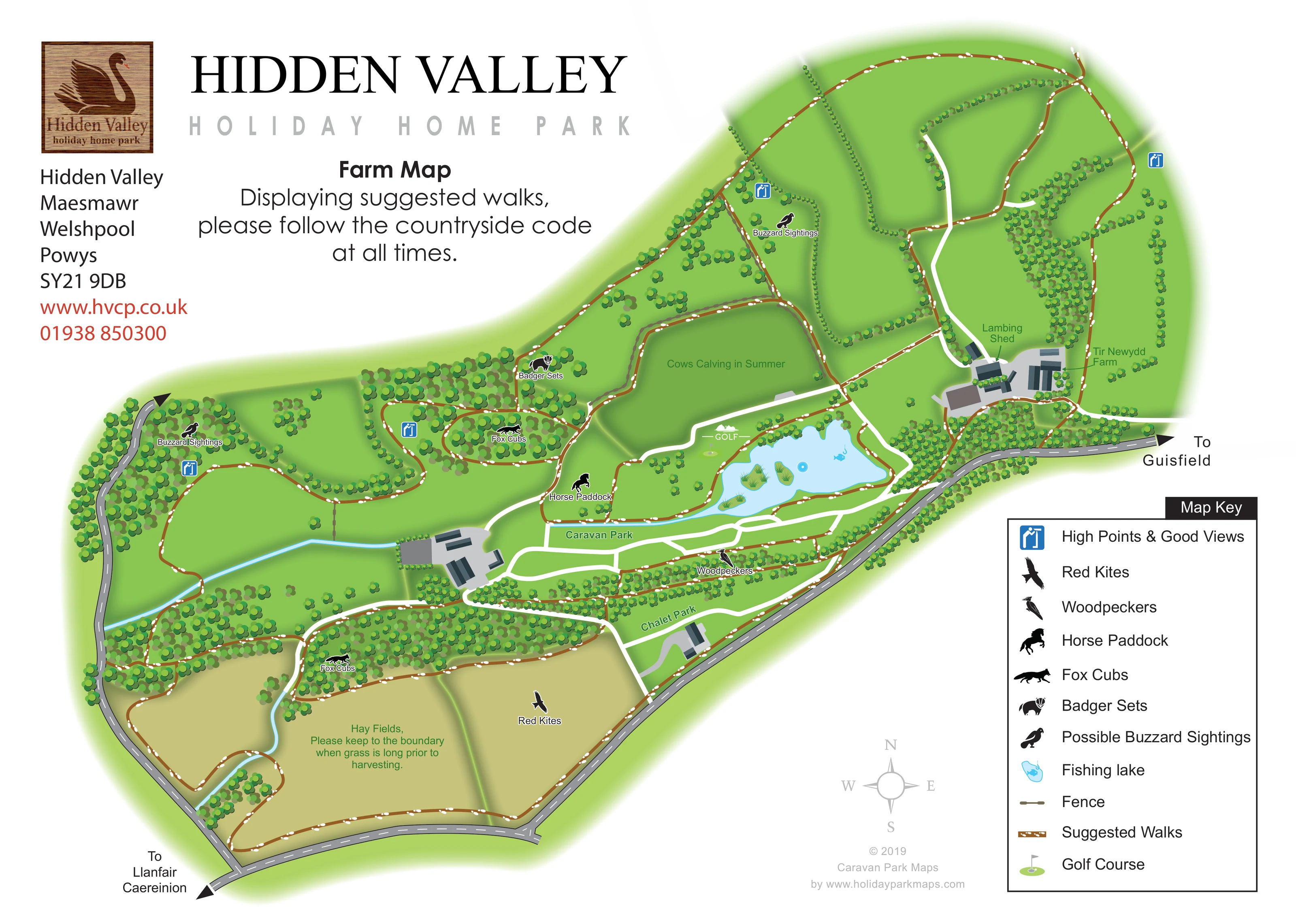
Blue viewpoint symbols mark several locations across the western woodland, central wooded routes and upper fields.
ILLUSTRATED PARK MAP · P497
Hidden Valley, Maesmawr, Welshpool, Powys · United Kingdom
 Enlarge the map ↗
A SENSE OF THE PLACE
Hidden Valley is a family-run holiday home park near Welshpool in Mid Wales. Static caravans and lodges overlook a private trout lake within a wooded valley.
Walking routes extend through surrounding farmland and woods. On-site leisure facilities include an indoor pool, gym, golf, fly fishing, tennis and a bowling green, giving holiday homeowners a range of ways to spend time at the park.
LOOK CLOSER
Blue viewpoint symbols mark several locations across the western woodland, central wooded routes and upper fields.
Dense clusters of stylised trees define woodland, roadside planting, field divisions and the boundaries around accommodation areas.
A narrow blue watercourse crosses the western landscape, with a branch running down between the lower fields; blue water also extends westwards from the lake.
Large muted yellow-green fields occupy the lower part of the map. An annotation asks walkers to keep to the boundary when grass is long before harvesting.
A horse silhouette and label identify a paddock west of the golf and lake area.
The central field is annotated Cows Calving in Summer, adding agricultural context to the walking landscape.
The upper-right farmyard contains simplified roofed buildings labelled Tir Newydd Farm and Lambing Shed, connected to white tracks and nearby walks.
Black silhouettes identify red kites over the lower fields, woodpeckers near the accommodation-side woodland and buzzard sighting areas in western and upper woodland. These are wildlife-interest markers, not guaranteed sightings.
Brown lines patterned with white footprints form interconnected walks around fields, through woodland, beside the lake and around the wider farm.
Blue viewpoint symbols mark several locations across the western woodland, central wooded routes and upper fields.
A prominent pale-blue lake sits above the Caravan Park, with planted islands, a fish-and-hook symbol and a small circular water detail. Suggested walks follow much of its edge.
A flag-and-green illustration labelled GOLF identifies the golf area immediately west of the lake.
Dense clusters of stylised trees define woodland, roadside planting, field divisions and the boundaries around accommodation areas.
A narrow blue watercourse crosses the western landscape, with a branch running down between the lower fields; blue water also extends westwards from the lake.
Large muted yellow-green fields occupy the lower part of the map. An annotation asks walkers to keep to the boundary when grass is long before harvesting.
A horse silhouette and label identify a paddock west of the golf and lake area.
The central field is annotated Cows Calving in Summer, adding agricultural context to the walking landscape.
The upper-right farmyard contains simplified roofed buildings labelled Tir Newydd Farm and Lambing Shed, connected to white tracks and nearby walks.
Black silhouettes identify red kites over the lower fields, woodpeckers near the accommodation-side woodland and buzzard sighting areas in western and upper woodland. These are wildlife-interest markers, not guaranteed sightings.
Fox cub markers appear in two wooded areas, while a badger marker identifies a central woodland location. The artwork spells the latter label Badger Sets.
Muted segmented fence lines help divide selected fields and are explained in the map key.
Broad white routes connect the farmyard, lake-side area, Caravan Park, Chalet Park and other building groups, contrasting with the brown suggested walks.
Grey roads with dashed white centre lines frame the western and southern edges. Large arrows label directions To Guisfield and To Llanfair Caereinion; another arrow continues off the upper-left road.
The Farm Map heading is accompanied by a prominent request to follow the Countryside Code when using the suggested walks.
READING THE MAP
This illustrated farm map for Hidden Valley Holiday Home Park places the surrounding countryside at the centre of the visitor experience. Set at Maesmawr near Welshpool in Powys, the park is shown within a connected landscape of woodland, hedged fields, farm buildings and water. Rather than numbering holiday homes, the artwork identifies the Caravan Park and Chalet Park as broad areas and uses the remaining space to explain suggested walks.
Brown routes patterned with white footprints wind around the fishing lake, follow field edges and branch through wooded ground. Blue viewpoint signs and black wildlife silhouettes add useful points of interest, including buzzards, red kites, woodpeckers, fox cubs and badger setts. Agricultural labels identify hay fields, a horse paddock and a summer calving field.
The large Hidden Valley heading, swan logo and boxed map key give the page a clear structure. This sample is particularly relevant to rural holiday parks needing a companion walking map that connects their accommodation with the character and attractions of a wider estate.
The plan spreads diagonally across the page, with the holiday-home areas below the lake and the farm landscape extending upwards and outwards. Grey roads frame the western and southern edges, carrying directional arrows towards Guisfield and Llanfair Caereinion. Broad white internal routes link building groups, park areas and Tir Newydd Farm, while the suggested walks use a separate brown line filled with white footprints.
The pale-blue fishing lake is a central landmark, illustrated with small planted islands and a fish-and-hook symbol. A golf flag marks the neighbouring golf area. Below the water, the Caravan Park appears as an elongated green zone crossed by white routes; the Chalet Park occupies a smaller area beside the lower roadside woodland. Neither is presented as an individual-unit plan.
The walking network reaches into upper fields, loops through woodland and follows the boundaries of the lower hay fields. Blue signs identify high points and good views. Wildlife silhouettes mark buzzard sighting areas, red kites, woodpeckers, fox cubs and badger setts. The horse paddock, summer calving annotation, lambing shed and farmyard give the drawing a distinctly agricultural identity. A narrow blue watercourse adds another landscape feature in the western fields.
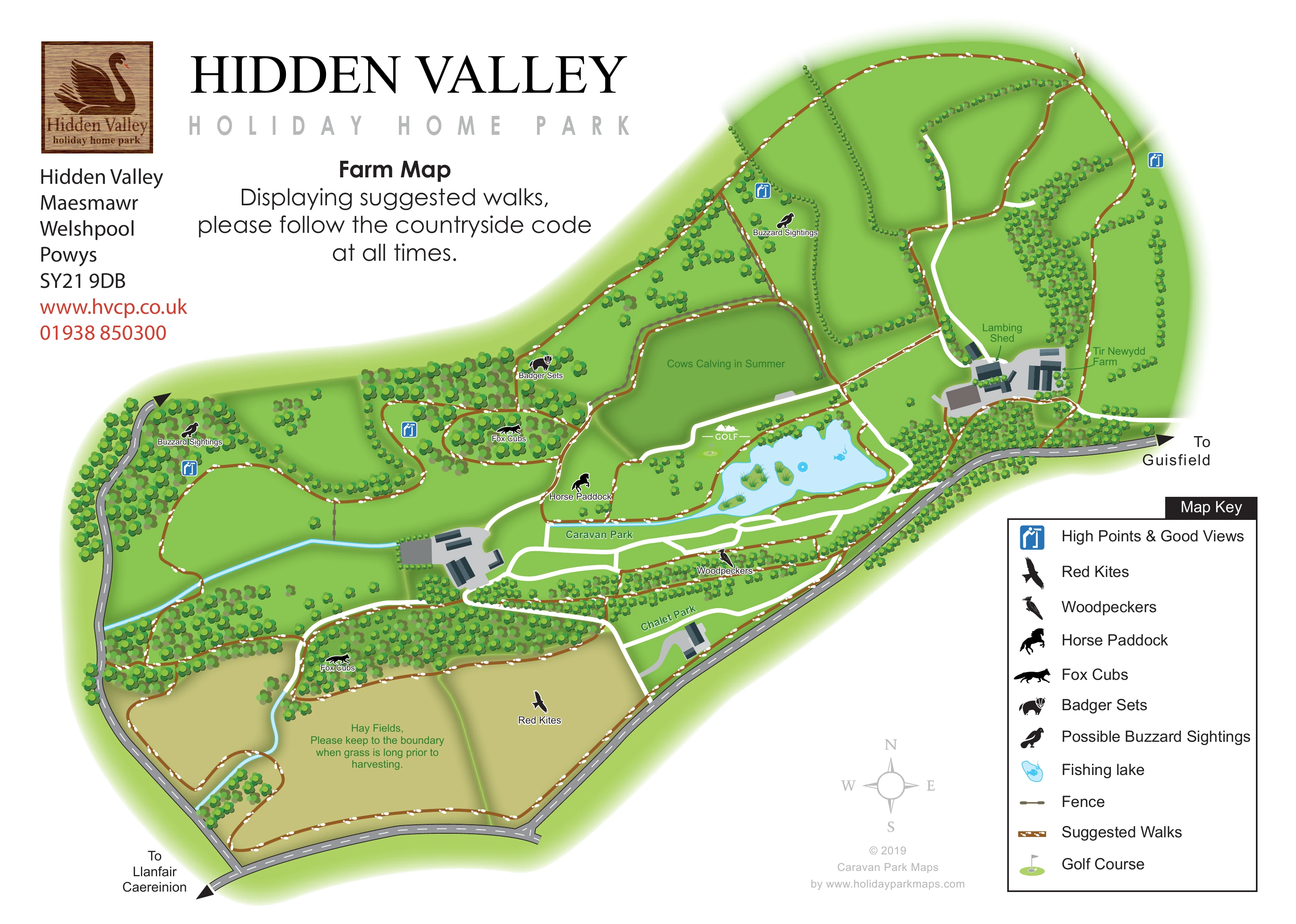
Repeated circular tree canopies distinguish woodland belts and hedgerows, while soft field shading suggests the rolling setting. The lower-right key explains route styles and pictorial symbols, and a pale compass rose provides orientation. Branding, contact information and the Countryside Code message occupy the open upper-left space. The accompanying detail view enlarges the same lake-side area and legend; it is not a separate map or additional park section.
KEEP EXPLORING
Chosen for shared landscapes, accommodation or facilities.
 Explore the map ↗
United Kingdom
Illustrated lakeside park plan with numbered holiday units, leisure buildings and a looping Woodland Walk.
 Explore the map ↗
United Kingdom
Woodland park map with mixed pitches, bell tents, lodges and a fishing lake.
 Explore the map ↗
United Kingdom
Illustrated caravan park plan with woodland and riverside walks, fishing pools and wildlife panels.
Features may come from the sample artwork, its key or published park information. Approximate numbers describe the drawing and may cover only part of a park. They are intended to help you compare map examples. Current facilities and booking information should be checked with the park.
TAKE A CLOSER LOOK
View the illustrated map in detail or choose a file to download. These are sample maps; contact the park for current visitor information.


LET’S MAP YOUR PARK
For a map quotation, find your park and draw a rough boundary around it. The area you select helps us work out the design time and price.
Draw your park for a quote ↗Or talk to our map designers
01751 473136
 widehiddenvalleymap_large.png