
Tree-lined boundaries and grass grounds
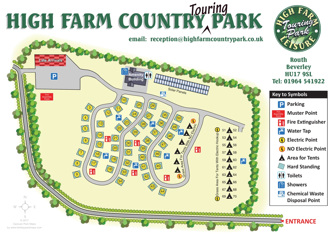
Illustrated trees and hedges enclose the touring area and line the approach road, with grass between the road loops.
ILLUSTRATED PARK MAP · P498
Routh, Beverley · United Kingdom
 Enlarge the map ↗
A SENSE OF THE PLACE
High Farm Holiday Park at Routh near Beverley offers holiday home ownership, touring pitches, camping pods and cottage accommodation. Landscaped grounds and woodland walks provide a countryside setting in East Yorkshire.
A golf course is one of the park's leisure features. The Yorkshire Wolds and coast offer further destinations for days out, while the map explains the relationship between accommodation areas and shared facilities.
LOOK CLOSER
Illustrated trees and hedges enclose the touring area and line the approach road, with grass between the road loops.
Numbered pale blue hardstandings arranged beside the internal loop roads, with yellow electric-point markers.
An eastern grass camping area is explicitly labelled for tents with electric hookup and includes numbered positions.
A narrow grass camping strip within the eastern road loop is labelled for tents without electric.
A labelled building beside the upper internal road carries toilet and shower symbols.
A chemical waste disposal symbol is placed near the amenity building and solar panels.
Blue tap symbols mark water points throughout the touring and camping areas.
Red extinguisher symbols are distributed among the pitches and camping areas.
Numbered pale blue hardstandings arranged beside the internal loop roads, with yellow electric-point markers.
An eastern grass camping area is explicitly labelled for tents with electric hookup and includes numbered positions.
A narrow grass camping strip within the eastern road loop is labelled for tents without electric.
A labelled building beside the upper internal road carries toilet and shower symbols.
A chemical waste disposal symbol is placed near the amenity building and solar panels.
Blue tap symbols mark water points throughout the touring and camping areas.
Red extinguisher symbols are distributed among the pitches and camping areas.
A red fire assembly point marker appears on the grass close to the parking area.
A broad grey parking area occupies the upper-left arrival zone.
A red hatched rectangle labelled Late Arrivals adjoins the parking area.
The entrance is marked at the lower right, feeding a perimeter approach road that follows the southern and western edges.
Rounded internal road loops organise access to the touring pitches and non-electric camping strip.
A long blue-and-white panel array is illustrated and labelled beside the amenity building.
Illustrated trees and hedges enclose the touring area and line the approach road, with grass between the road loops.
The wider park has woodland walks; their routes are not drawn on this touring-area plan.
A golf course is identified as a leisure feature of the wider park, outside the facilities depicted here.
READING THE MAP
This illustrated map of High Farm Country Park focuses on the touring and camping area at Routh, near Beverley in East Yorkshire. Rather than attempting to show every part of the wider holiday park, it gives visitors a clear picture of the entrance route, numbered hardstandings, tent areas and shared facilities.
The layout is organised around a tree-lined approach road and a series of rounded internal loops. Pale blue pitch rectangles and yellow electricity markers make the touring areas easy to distinguish from the grass camping spaces, which are explicitly separated into electric and non-electric areas. The amenity building, parking, late-arrivals space and service points are given prominent positions or recognisable symbols.
The artwork combines a practical overhead plan with softer landscape illustration. Layered green trees frame the site, while a restrained ground colour keeps the roads and pitch markers legible. A large symbol key and strong park branding complete the page. It is a useful sample for parks needing a dedicated touring-area map that explains pitch types and facilities without the complexity of a full resort plan.
The plan presents the touring area from directly above, with a pale yellow-green ground colour and a continuous border of illustrated trees and hedges. The entrance is marked in red at the lower right. From there, a grey approach road runs along the southern boundary and curves up the western side to a broad parking and late-arrivals area in the upper left. An internal road then leads past the amenity building and branches into long, rounded loops serving the pitches.
Numbered touring hardstandings appear as small pale blue rectangles, rotated to follow the road layout. Yellow circular markers indicate electricity provision. Most of these pitches occupy the central and western portions of the plan. Camping is distinguished on the eastern side: a narrow grass strip within the final road loop is labelled for tents without electric, while a separate grass area farther right is labelled for tents with electric hookup. Black tent symbols identify the camping areas rather than illustrating individual occupied tents.
The amenity building sits beside the upper road, with toilet and shower symbols attached to it. A long illustrated bank of solar panels lies immediately to its right, and a chemical waste disposal symbol appears nearby. Blue water-tap symbols and red fire-extinguisher symbols are distributed through the pitch areas. A fire assembly point is marked on grass near the parking area.
A prominent heading spans the top of the sheet, combining dark green capital lettering with a handwritten-style ‘Touring’ addition. A circular park logo, contact information and a boxed symbol key occupy the right-hand column. A small compass and designer credit sit at the lower left, leaving the main plan uncluttered.
KEEP EXPLORING
Chosen for shared landscapes, accommodation or facilities.
 Explore the map ↗
United Kingdom
Woodland-framed Barnsoul map with mixed accommodation, shared facilities and paw-marked walking routes.
 Explore the map ↗
United Kingdom
A colour-zoned coastal park map with touring areas, woodland trails, ponds and a leisure club.
 Explore the map ↗
United Kingdom
Colour-coded accommodation, lakeside facilities and woodland routes at Burton Constable Holiday Park & Arboretum.
Features may come from the sample artwork, its key or published park information. Approximate numbers describe the drawing and may cover only part of a park. They are intended to help you compare map examples. Current facilities and booking information should be checked with the park.
TAKE A CLOSER LOOK
View the illustrated map in detail or choose a file to download. These are sample maps; contact the park for current visitor information.


LET’S MAP YOUR PARK
For a map quotation, find your park and draw a rough boundary around it. The area you select helps us work out the design time and price.
Draw your park for a quote ↗Or talk to our map designers
01751 473136