
River Irfon
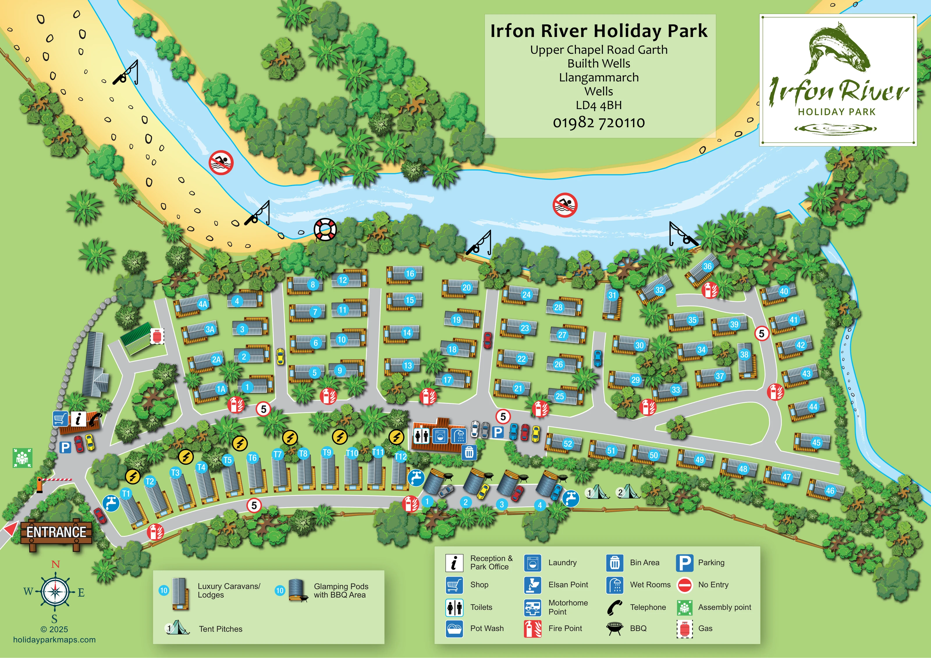
A broad, curving blue river dominates the upper half of the artwork, with white current strokes, yellow stony banks and a narrower watercourse along the eastern boundary.
ILLUSTRATED PARK MAP · P175
Upper Chapel Road, Garth, Builth Wells, Llangammarch Wells · United Kingdom
 Enlarge the map ↗
A SENSE OF THE PLACE
Irfon River Holiday Park is a family-run caravan and lodge ownership park near Builth Wells. Meadows and woodland beside the River Irfon create its setting.
The park has a gated entrance and an owners-only approach, with no subletting. Its location provides a base for outings around Mid Wales, including the towns and landscapes of the Wye Valley, Bannau Brycheiniog and the Elan Valley.
LOOK CLOSER
A broad, curving blue river dominates the upper half of the artwork, with white current strokes, yellow stony banks and a narrower watercourse along the eastern boundary.
Dense illustrated trees follow the river and site boundaries, with smaller groups separating accommodation and screening service areas.
Information symbol on the building just inside the western entrance, shared with shop and telephone symbols.
Shopping-trolley symbol at the reception-side building near the entrance.
Telephone handset symbol beside the reception and shop.
A central-southern service building is marked with toilet, shower/wet-room and washing-machine symbols.
Parking symbols appear beside reception and the sanitary/laundry building; coloured cars also illustrate parking beside the pods and along internal roads.
Blue tap symbols are positioned along the southern accommodation row and beside the pods.
Information symbol on the building just inside the western entrance, shared with shop and telephone symbols.
Shopping-trolley symbol at the reception-side building near the entrance.
Telephone handset symbol beside the reception and shop.
A central-southern service building is marked with toilet, shower/wet-room and washing-machine symbols.
Parking symbols appear beside reception and the sanitary/laundry building; coloured cars also illustrate parking beside the pods and along internal roads.
Blue tap symbols are positioned along the southern accommodation row and beside the pods.
Yellow lightning-bolt circles accompany the T-prefixed accommodation row. The artwork does not provide a corresponding legend explanation.
Individual barbecue illustrations accompany the glamping pods and are explained by the accommodation legend.
A bin symbol is placed beside the central sanitary/laundry building.
A red gas-cylinder symbol marks a small building north of reception.
Repeated red extinguisher symbols mark points throughout the accommodation roads.
A green assembly-point symbol sits beside the western entrance approach.
Included in the facilities key, without a clearly identifiable placement on the plan.
Included in the facilities key; no clear mapped position is visible.
A motorhome service-point symbol is defined in the key, but its location is not clearly shown.
A broad, curving blue river dominates the upper half of the artwork, with white current strokes, yellow stony banks and a narrower watercourse along the eastern boundary.
Fishing-rod pictograms are distributed along the riverbank, presenting fishing as a distinctive riverside feature without stating permissions or arrangements.
The river carries crossed-out swimming pictograms, and a lifebuoy illustration appears at the bank.
Dense illustrated trees follow the river and site boundaries, with smaller groups separating accommodation and screening service areas.
A large wooden entrance sign and red arrow identify arrival from the lower left; a striped barrier is illustrated farther along the approach.
Grey, white-edged roads connect the entrance, southern accommodation strip, central spine, short accommodation branches and eastern turning loop.
Red-ringed signs displaying '5' recur on the internal roads.
Defined in the facilities key, without a clear corresponding position on the plan.
READING THE MAP
The River Irfon gives this illustrated holiday park map its shape and character. A broad blue bend sweeps across the top of the page, with stony banks, fishing symbols and dense green planting setting the scene for the accommodation below. The map presents Irfon River Holiday Park at Garth, near Builth Wells in Mid Wales, as a compact riverside site with clearly organised roads and a varied accommodation layout.
Most of the plan is occupied by numbered caravans and lodges, arranged in rows between short access lanes. A separate southern strip introduces glamping pods with barbecue areas and a pair of marked tent pitches. Reception, the shop and the entrance barrier form an easy-to-recognise arrival cluster, while a central service building brings together toilets, wet rooms and laundry symbols.
The design combines practical navigation with a strong sense of place. Cyan plot markers stand out against the green landscape, two boxed legends explain accommodation and facilities, and the fish-themed park logo reinforces the river setting. It is a useful sample for parks wanting their natural surroundings to remain prominent without losing the clarity of a numbered site plan.
The plan is organised around an entrance at the lower-left corner, marked by a large timber-style sign, a red arrow and an illustrated barrier. Reception and the park office sit just inside this approach, with shop and telephone symbols on the same building and parking nearby. A gas marker appears at a smaller building farther north, while the assembly point is positioned beside the entrance route.
From here, grey roads with white borders lead through the accommodation. The main central road connects several short northward lanes, each serving rows of caravans/lodges, before opening into a curved turning loop on the eastern side. Accommodation near the north-eastern riverbank is arranged less regularly among the trees. A long row follows the southern side of the main road, and a separate lower lane serves the T-prefixed units, four illustrated pods with barbecues and two marked tent pitches.
The central-southern service building carries toilet, laundry and wet-room symbols, with parking and a bin marker alongside. Water taps appear along the lower accommodation strip, yellow electricity markers accompany the T-prefixed row, and red fire-point symbols recur across the road network. Red-ringed '5' signs add another layer of route information. The facilities key also defines pot wash, Elsan and motorhome points, plus a no-entry symbol, without clearly locating those entries on the plan.
Above the accommodation, the river is drawn with white current strokes, pale stony banks, fishing-rod symbols, crossed-out swimming pictograms and a lifebuoy. Layered foliage and timber fencing frame the site. This single landscape-format artwork places the title and logo above the river and the two legends below the plan; the enlarged detail views show portions of the same design.
KEEP EXPLORING
Chosen for shared landscapes, accommodation or facilities.
 Explore the map ↗
United Kingdom
Woodland park map with mixed pitches, bell tents, lodges and a fishing lake.
 Explore the map ↗
United Kingdom
A woodland estate park map combining caravan loops, touring pitches, riverside paths and Bruce’s Cave landmarks.
 Explore the map ↗
United Kingdom
Illustrated caravan park plan with woodland and riverside walks, fishing pools and wildlife panels.
Features may come from the sample artwork, its key or published park information. Approximate numbers describe the drawing and may cover only part of a park. They are intended to help you compare map examples. Current facilities and booking information should be checked with the park.
LET’S MAP YOUR PARK
For a map quotation, find your park and draw a rough boundary around it. The area you select helps us work out the design time and price.
Draw your park for a quote ↗Or talk to our map designers
01751 473136