
River Alne
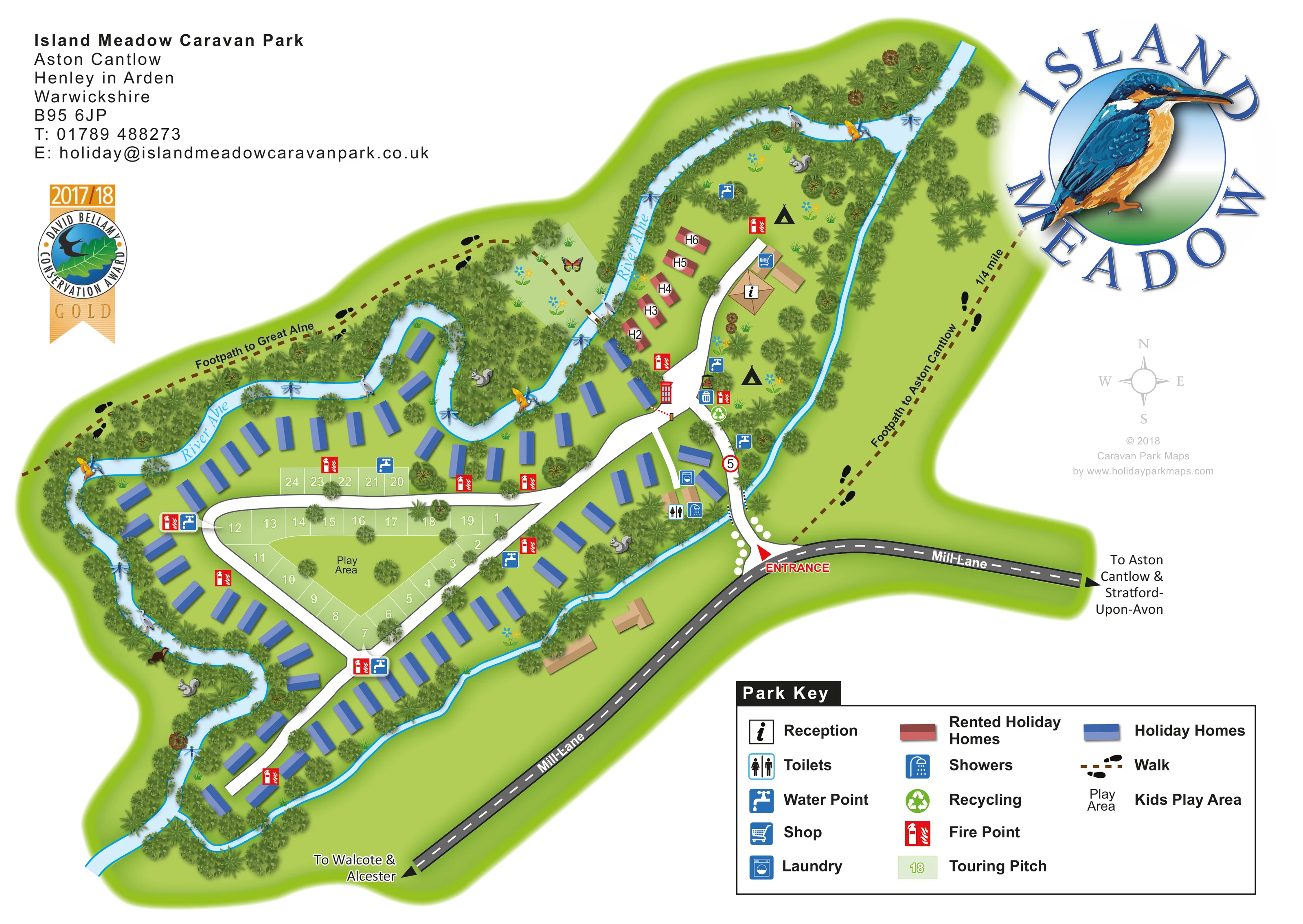
The named river winds along the northern and western sides, with dense illustrated vegetation lining its banks.
ILLUSTRATED PARK MAP · P507
Island Meadow Caravan Park, Aston Cantlow, Henley in Arden, Warwickshire · United Kingdom
 Enlarge the map ↗
A SENSE OF THE PLACE
Island Meadow Caravan Park is based at Aston Cantlow, Henley in Arden, Warwickshire. This is a family-run park on an island formed by the River Alne and its mill race, within seven acres. Riverside holiday caravans, two-person pods and a six-berth pod are offered. Dedicated tent areas are named the Orchard and the Garden.
Heated toilet and shower block, accessible facilities and a licensed shop are listed. A two-acre touring area has 24 pitches with 10-amp electric hook-ups.
LOOK CLOSER
The named river winds along the northern and western sides, with dense illustrated vegetation lining its banks.
A narrower blue-edged watercourse follows the eastern and southern boundary, helping explain the park's island form.
Layered trees, shrubs and reeds form green corridors between the river, holiday homes and open lawns.
An information symbol marks the tan-roofed reception building beside the northern branch of the internal road.
A shopping-trolley symbol locates the shop in the building group beside reception.
Toilet and shower symbols mark the amenity building near the entrance-side accommodation.
A washing-machine symbol is shown beside the entrance-side amenity buildings.
Repeated blue tap symbols are distributed around the touring loop, southern junction and northern camping areas.
An information symbol marks the tan-roofed reception building beside the northern branch of the internal road.
A shopping-trolley symbol locates the shop in the building group beside reception.
Toilet and shower symbols mark the amenity building near the entrance-side accommodation.
A washing-machine symbol is shown beside the entrance-side amenity buildings.
Repeated blue tap symbols are distributed around the touring loop, southern junction and northern camping areas.
Red fire-point symbols appear throughout the accommodation areas and beside road junctions.
A green recycling symbol and blue bin symbol sit together near the central road junction below reception.
The central triangular lawn is labelled Play Area and is enclosed by touring pitches and the loop road.
An unkeyed red telephone-box illustration appears near the junction below reception.
The named river winds along the northern and western sides, with dense illustrated vegetation lining its banks.
A narrower blue-edged watercourse follows the eastern and southern boundary, helping explain the park's island form.
Layered trees, shrubs and reeds form green corridors between the river, holiday homes and open lawns.
A red arrow and ENTRANCE label mark the approach from Mill Lane on the eastern side.
White roads form a central triangular loop, a northern reception branch and a long south-western accommodation spur.
A brown dashed route with black footprints follows the northern side towards Great Alne.
A similarly styled path runs along the eastern side and is labelled Footpath to Aston Cantlow, with a quarter-mile annotation.
Mill Lane has directional arrows towards Walcote and Alcester, and towards Aston Cantlow and Stratford-upon-Avon.
READING THE MAP
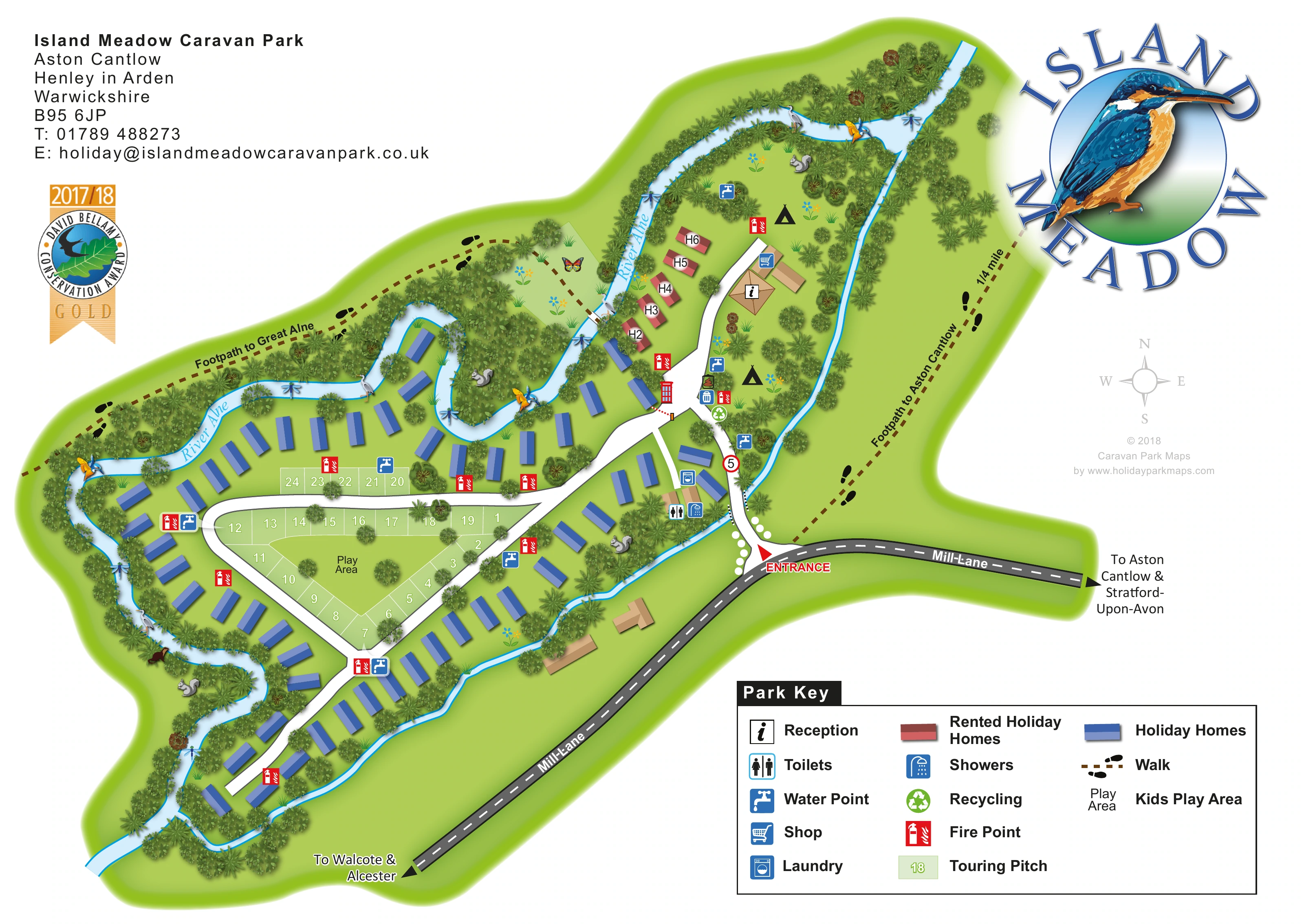
This illustrated map of Island Meadow Caravan Park makes its riverside setting the main organising feature. Located at Aston Cantlow, near Henley in Arden in Warwickshire, the park is shown between the winding River Alne and a narrower boundary watercourse. Blue holiday homes follow the banks, while a compact group of red rental homes sits close to reception. At the centre, numbered touring pitches wrap around a triangular play lawn, giving visitors a clear landmark within the road layout.
The artwork combines practical arrival information with a distinctive countryside identity. Mill Lane, the entrance and local road directions are prominent, and footprint-marked paths point towards Great Alne and Aston Cantlow. A substantial key explains the accommodation colours and facilities, including the shop, laundry, toilets, showers, water points and recycling. Trees, reeds and small wildlife illustrations soften the plan without obscuring its structure. The large kingfisher logo reinforces the river theme, while the white page margins provide space for park details and the legend. It is a useful example of a mixed-accommodation map built around an unusual natural boundary.
The single landscape-format plan shows the park as an elongated green island, with its entrance on the eastern side beside Mill Lane. A red arrow identifies the turn into the park. The white internal road crosses the narrow watercourse and branches towards reception, the central touring loop and the long south-western holiday-home area. External road arrows point towards Walcote and Alcester in one direction, and Aston Cantlow and Stratford-upon-Avon in the other.
The central road encloses a triangular arrangement of touring pitches around a lawn labelled Play Area. Further touring parcels sit along the northern edge of this loop. Blue holiday-home symbols line the surrounding river margins and continue along the southern spur. A separate red, H-labelled rental group follows the river near reception. Two black tent symbols mark open northern lawns, although the map does not subdivide these into countable camping pitches.
Reception and the shop occupy tan-roofed buildings on the northern branch. Toilets, showers and laundry are marked nearer the entrance, while recycling and bin symbols cluster at the junction below reception. Water points and red fire-point symbols recur across the plan. A small telephone-box illustration provides another visual landmark.
The River Alne is labelled along its winding course. Dense trees and bank planting separate accommodation from the water, with birds, insects and other wildlife adding a pictorial layer. Brown dashed footpaths with black footprints lead towards Great Alne and Aston Cantlow. The upper corners hold park details, an award graphic and the kingfisher logo; the lower-right key explains the main symbols. The accompanying enlargements show portions of this same artwork, including the key, rather than additional park sections.
KEEP EXPLORING
Chosen for shared landscapes, accommodation or facilities.
 Explore the map ↗
United Kingdom
Riverside park map with named pitch fields, illustrated huts and a paw-print dog walk.
 Explore the map ↗
United Kingdom
Woodland holiday homes, named camping fields and farm buildings on a colour-coded Nether Wasdale park map.
 Explore the map ↗
United Kingdom
Illustrated caravan park plan with woodland and riverside walks, fishing pools and wildlife panels.
Features may come from the sample artwork, its key or published park information. Approximate numbers describe the drawing and may cover only part of a park. They are intended to help you compare map examples. Current facilities and booking information should be checked with the park.
TAKE A CLOSER LOOK
View the illustrated map in detail or choose a file to download. These are sample maps; contact the park for current visitor information.


LET’S MAP YOUR PARK
For a map quotation, find your park and draw a rough boundary around it. The area you select helps us work out the design time and price.
Draw your park for a quote ↗Or talk to our map designers
01751 473136
 islandmeadow_large.png