
Woodland setting
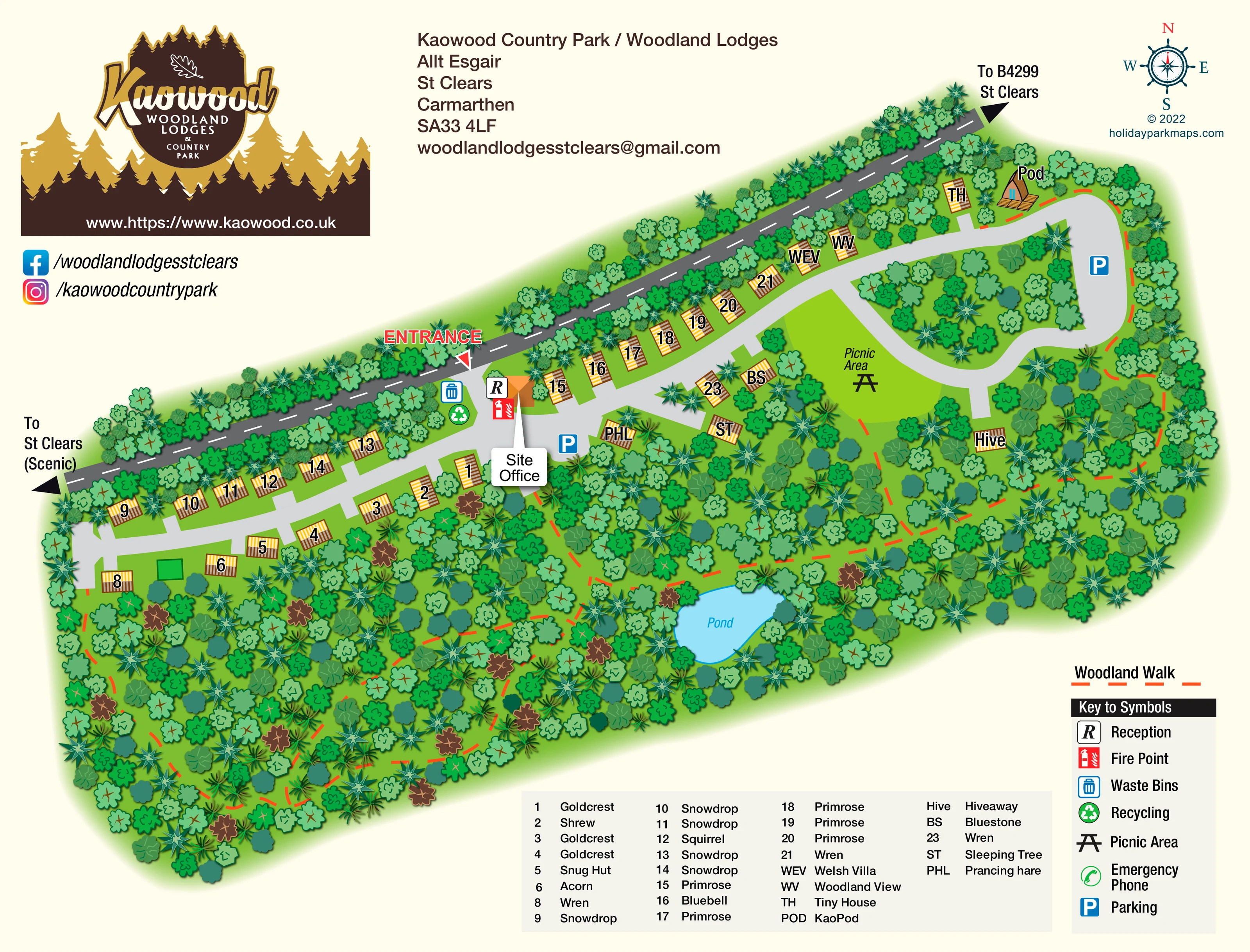
Dense, varied tree symbols surround the accommodation, line the external road and fill the southern part of the site.
ILLUSTRATED PARK MAP · P508
Kaowood Country Park / Woodland Lodges, Allt Esgair, St Clears, Carmarthen · United Kingdom
 Enlarge the map ↗
A SENSE OF THE PLACE
Kaowood Country Park offers detached self-catering lodges in woodland near St Clears in Carmarthenshire. Different lodge sizes accommodate couples, families and small groups.
Woodland walks, a pond and a picnic area provide outdoor spaces within the grounds. Dog-friendly accommodation and lodges with private hot tubs are available, with the map helping guests locate each property within the wooded setting.
LOOK CLOSER
Dense, varied tree symbols surround the accommodation, line the external road and fill the southern part of the site.
An irregular blue pond is labelled within the woodland below the main accommodation road.
An orange-roofed building beside the entrance carries the reception symbol and a prominent Site Office callout.
Blue parking symbols mark an area near the site office and another within the eastern road loop.
Waste-bin and recycling symbols are grouped beside the entrance and reception area.
A red fire-point symbol is shown beside reception.
A labelled grassy clearing with a picnic-table symbol occupies the interior of the eastern loop.
Orange-red dashed walking routes weave through the woodland, with branches around the pond and towards the picnic area and eastern accommodation.
An orange-roofed building beside the entrance carries the reception symbol and a prominent Site Office callout.
Blue parking symbols mark an area near the site office and another within the eastern road loop.
Waste-bin and recycling symbols are grouped beside the entrance and reception area.
A red fire-point symbol is shown beside reception.
A labelled grassy clearing with a picnic-table symbol occupies the interior of the eastern loop.
Included in the symbol key; a corresponding location is not clearly identifiable on the plan.
Dense, varied tree symbols surround the accommodation, line the external road and fill the southern part of the site.
An irregular blue pond is labelled within the woodland below the main accommodation road.
Orange-red dashed walking routes weave through the woodland, with branches around the pond and towards the picnic area and eastern accommodation.
A large ENTRANCE label and triangular pointer identify the turn from the external road into the park beside reception.
A broad pale-grey drive serves the linear lodge groups, then curves into a loop at the eastern end with short branches to other properties.
The dark external road has directional arrows towards the B4299 and St Clears at one end, and towards St Clears via a scenic route at the other.
A decorative compass rose in the upper-right corner provides cardinal orientation.
READING THE MAP
This illustrated map of Kaowood Country Park places its woodland setting at the centre of the visitor experience. Located at Allt Esgair near St Clears in Carmarthenshire, the park is shown as an elongated, tree-filled site with detached holiday accommodation arranged along a simple internal drive. Roughly 30 accommodation units give the plan a small-park scale, while the many individual property names make clear identification especially important.
The artwork combines practical arrival information with a strong sense of place. Reception, parking, waste and recycling are easy to distinguish near the entrance, and a loop at the eastern end connects further accommodation with a picnic clearing. Orange-red dashed woodland walks thread through the trees and past a blue pond, contrasting clearly with the grey vehicle routes.
A large brown-and-gold Kaowood logo, varied green tree canopies and warm timber-coloured buildings give the page a distinctive woodland character. Separate accommodation and facility keys help guests move from their booking name to a recognisable position on the plan.
The plan follows a long diagonal road frontage, with the external road shown in charcoal grey and labelled towards St Clears and the B4299. A conspicuous entrance pointer leads into the park beside the orange-roofed site office. Reception, a fire point, waste bins and recycling are grouped here, making the arrival area a clear visual anchor.
From this junction, the pale-grey internal drive runs west between staggered lodge groups and east along another row before forming a rounded loop. Short branches reach properties deeper in the trees. Blue parking symbols appear near the office and within the eastern loop. The loop encloses woodland and a bright green picnic clearing, while Hiveaway sits nearby on a smaller branch. Tiny House and KaoPod occupy the upper-right section, with the pod given a more distinctive peaked building illustration.
Accommodation is labelled using a mixture of numbers and short codes. The broad key along the bottom translates these into property names, including Goldcrest, Shrew, Snowdrop, Primrose, Welsh Villa, Woodland View, Sleeping Tree and Prancing hare. This allows a guest to locate a named booking without requiring the full name to fit over every small building.
The southern woodland is illustrated with overlapping tree canopies in several shapes and green tones. Orange-red dashed paths weave through this area and around the labelled pond, providing a route network separate from the drives. A compact facility legend occupies the lower-right corner, with the woodland-walk line sample immediately above it. The complete artwork is accompanied by overlapping enlargements of its lower keys; these are detail views, not additional park sections.
KEEP EXPLORING
Chosen for shared landscapes, accommodation or facilities.
 Explore the map ↗
United Kingdom
Woodland-framed Barnsoul map with mixed accommodation, shared facilities and paw-marked walking routes.
 Explore the map ↗
United Kingdom
A colour-zoned coastal park map with touring areas, woodland trails, ponds and a leisure club.
 Explore the map ↗
United Kingdom
Woodland holiday-park map with named accommodation areas, touring loops and illustrated recreation facilities.
Features may come from the sample artwork, its key or published park information. Approximate numbers describe the drawing and may cover only part of a park. They are intended to help you compare map examples. Current facilities and booking information should be checked with the park.
LET’S MAP YOUR PARK
For a map quotation, find your park and draw a rough boundary around it. The area you select helps us work out the design time and price.
Draw your park for a quote ↗Or talk to our map designers
01751 473136