
Planted park boundary
Dense illustrated trees, shrubs and spiky foliage follow the northern roadside and both tapering sides of the park.
ILLUSTRATED PARK MAP · P179
Kennack Sands Holiday Park, Kuggar, Helston · United Kingdom
 Enlarge the map ↗
A SENSE OF THE PLACE
Kennack Sands Holiday Park offers holiday home ownership near the beach on Cornwall's Lizard Peninsula. Landscaped green spaces and a quieter atmosphere shape the park's character.
A heated outdoor swimming pool is among the advertised facilities. Its map illustrates the arrangement of holiday homes and shared spaces, with the nearby coast providing opportunities for beach days and walking.
LOOK CLOSER
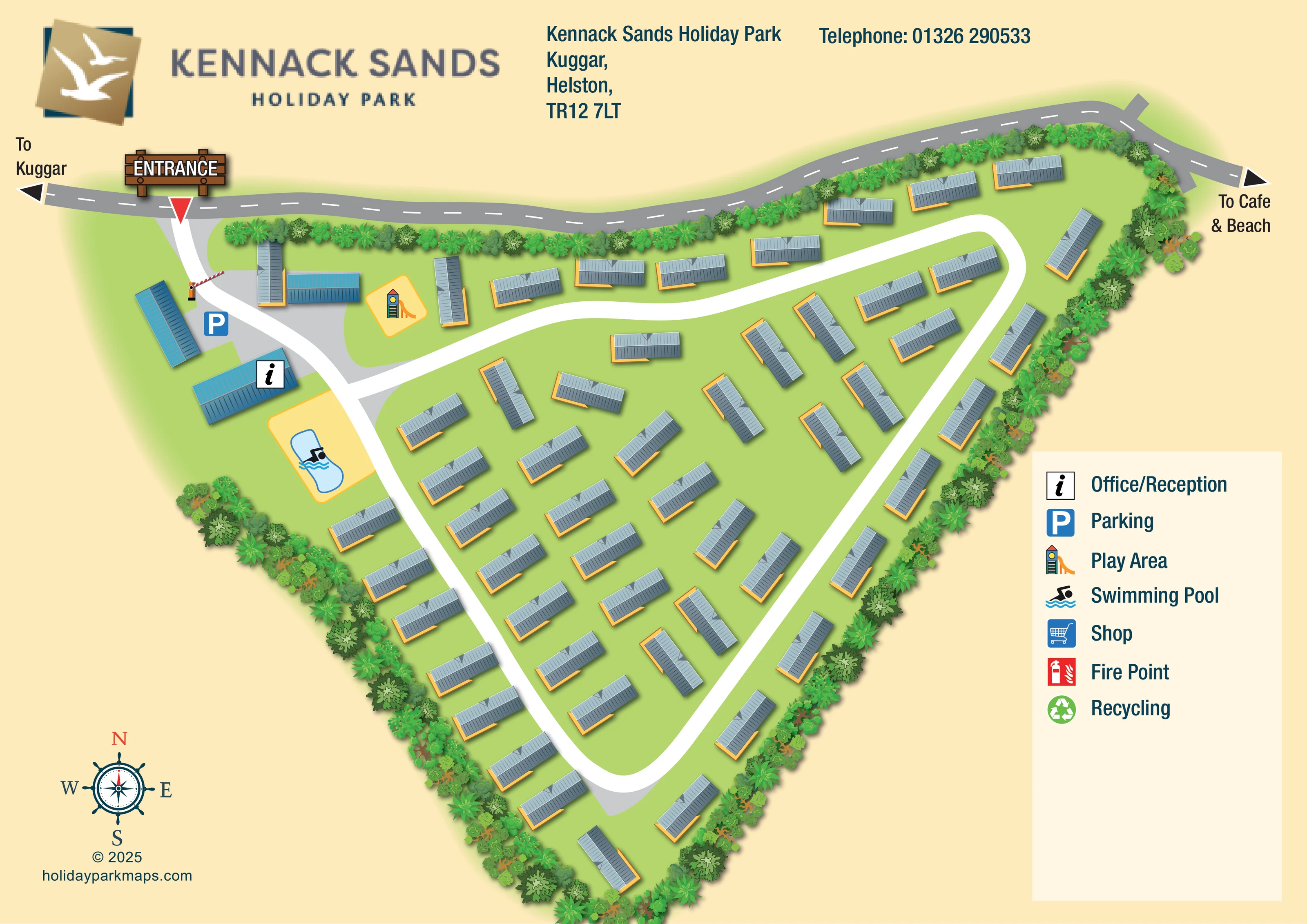
Dense illustrated trees, shrubs and spiky foliage follow the northern roadside and both tapering sides of the park.
A continuous light-green ground colour separates the individual homes and leaves open space around the shared facilities.
An information symbol identifies a blue-roofed building beside the arrival area, just south of the entrance parking.
A blue P symbol marks the grey arrival area immediately inside the entrance.
A tower-and-slide illustration sits on a rounded yellow ground panel east of the entrance buildings.
A pale-blue, rounded pool with a swimmer symbol occupies a yellow surround beside reception and the western arm of the internal road.
A wooden ENTRANCE sign and red pointer identify the north-western access from the external road. A red-and-white barrier is illustrated farther inside.
Broad white routes branch near reception, run east across the upper park and descend along both sides before joining in a rounded southern bend.
An information symbol identifies a blue-roofed building beside the arrival area, just south of the entrance parking.
A blue P symbol marks the grey arrival area immediately inside the entrance.
A tower-and-slide illustration sits on a rounded yellow ground panel east of the entrance buildings.
A pale-blue, rounded pool with a swimmer symbol occupies a yellow surround beside reception and the western arm of the internal road.
Published park information describes the swimming pool as heated and outdoors; the heating detail is not conveyed by the map symbol.
A shopping trolley symbol appears in the key, but no corresponding location is clearly marked on the plan.
The key includes a red fire-point symbol; a position is not clearly shown in the mapped park.
A green recycling symbol is listed in the key without a clearly visible placement on the plan.
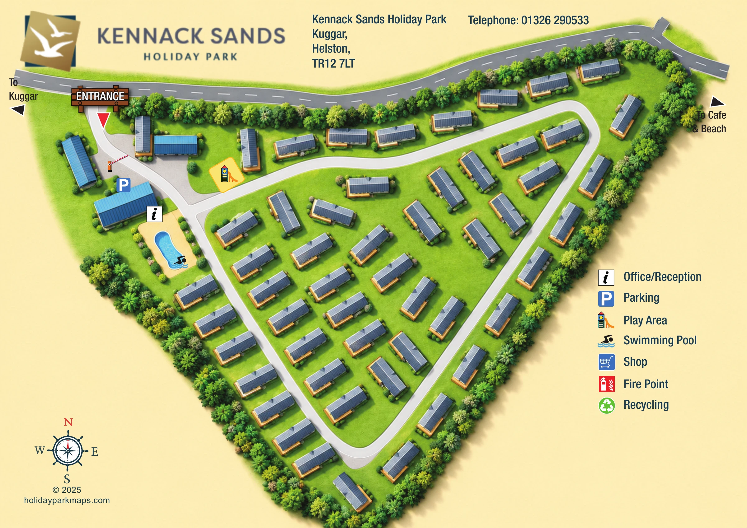
Dense illustrated trees, shrubs and spiky foliage follow the northern roadside and both tapering sides of the park.
A continuous light-green ground colour separates the individual homes and leaves open space around the shared facilities.
A wooden ENTRANCE sign and red pointer identify the north-western access from the external road. A red-and-white barrier is illustrated farther inside.
Broad white routes branch near reception, run east across the upper park and descend along both sides before joining in a rounded southern bend.
A left-facing arrow on the external road is labelled To Kuggar.
A right-facing arrow is labelled To Cafe & Beach. These are off-map destinations rather than facilities positioned within the park.
READING THE MAP
This illustrated map of Kennack Sands Holiday Park presents a compact holiday-home setting at Kuggar, near Helston on Cornwall’s Lizard Peninsula. Its tapering layout is easy to recognise: a broad road frontage at the top narrows towards a planted southern tip, with individual caravan-style holiday homes arranged around a long internal loop. A directional arrow towards the café and beach connects the park plan to its coastal surroundings without adding a separate location inset.
The arrival area is a clear focal point. A wooden entrance sign, red pointer and illustrated barrier lead into parking and reception, with the play area and swimming pool close by. Grey-roofed holiday homes contrast with blue-roofed shared buildings, while yellow amenity surrounds help the leisure spaces stand out against the green ground.
Seagull branding, a nautical compass rose and a warm cream page background give the artwork a coastal character. The sample demonstrates a pictorial approach to explaining a holiday-home park through its roads, buildings, planting and principal shared spaces.
The plan centres on a roughly triangular park enclosed by illustrated planting. Along the northern edge, a grey external road carries dashed white markings and arrows towards Kuggar on the left and the café and beach on the right. The north-western entrance is emphasised with a timber-style sign and red pointer; a red-and-white barrier marks the route into the arrival area.
Parking and a blue-roofed reception building sit beside this approach. Nearby, a small tower-and-slide illustration identifies the play area, while a pale-blue pool occupies a yellow surround south of reception. These facilities are concentrated near the entrance rather than dispersed among the holiday homes.
Beyond the arrival area, broad white roads describe an elongated loop. Its upper arm sweeps east beneath the roadside row of homes, then turns down the eastern side. The western arm descends past the pool and joins it at a rounded bend near the southern end. Roughly 55 static caravan-style holiday homes occupy the outer margins and staggered central rows, with their angles responding to the roads and narrowing footprint.
The accommodation drawings combine ribbed blue-grey roofs, golden-yellow edges and soft shadows. Dense trees and shrubs frame the perimeter, leaving the central ground visually simple. The single-page composition places park branding and contact details across the top, a compass at lower left and a large key at lower right. That key explains the four clearly located facilities and also lists shop, fire-point and recycling symbols, whose positions are not marked clearly on the plan. No plot numbering or separate route inset is shown.
 Enlarge this map ↗
KEEP EXPLORING
Chosen for shared landscapes, accommodation or facilities.
 Explore the map ↗
United Kingdom
Coastal park map with static-caravan rows, touring pitches, a camping field and two leisure clusters.
 Explore the map ↗
United Kingdom
A colour-zoned coastal park map with touring areas, woodland trails, ponds and a leisure club.
 Explore the map ↗
United Kingdom
Colour-coded accommodation, central leisure facilities and coastal paths on an illustrated headland park map.
Features may come from the sample artwork, its key or published park information. Approximate numbers describe the drawing and may cover only part of a park. They are intended to help you compare map examples. Current facilities and booking information should be checked with the park.
LET’S MAP YOUR PARK
For a map quotation, find your park and draw a rough boundary around it. The area you select helps us work out the design time and price.
Draw your park for a quote ↗Or talk to our map designers
01751 473136