
Harriers Pond
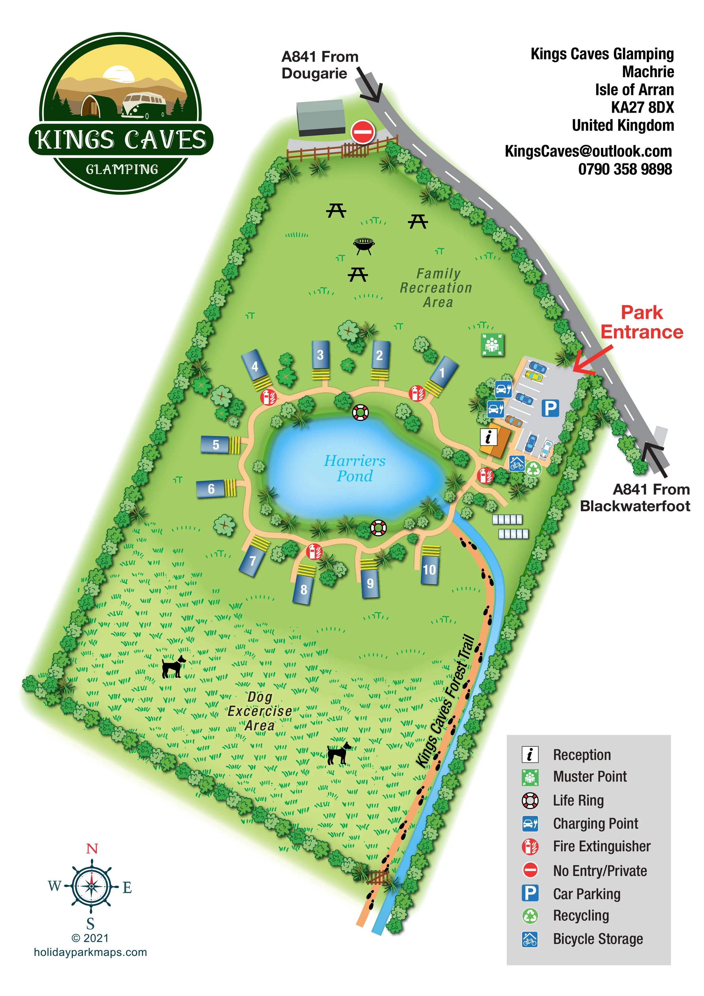
Named central pond, surrounded by planting, a looping footpath and the glamping accommodation.
ILLUSTRATED PARK MAP · P513
Machrie, Isle of Arran · United Kingdom
 Enlarge the map ↗
A SENSE OF THE PLACE
Kings Caves Glamping is based at Machrie, Isle of Arran. The park is near Machrie Beach, Machrie Moor standing stones and King's Caves walking trails. The current homepage advertises seven glamping lodges.
Communal guest amenities include a spa hot tub, EV charger and fire-pit/barbecue area. Lodges have mini-kitchens, Wi-Fi, smart televisions and decking overlooking the pond.
LOOK CLOSER
Named central pond, surrounded by planting, a looping footpath and the glamping accommodation.
A narrow blue watercourse extends from the pond area down the eastern side of the site, alongside the forest trail.
Continuous stylised planting defines most of the site perimeter, with additional trees and shrubs between units and beside the pond.
Open lawn in the northern portion of the site, illustrated with picnic tables and a barbecue.
Black picnic-table silhouettes and a kettle-style barbecue distinguish the shared recreation lawn.
A large grassed area occupies the southern part of the plan, labelled for dog exercise and illustrated with dog silhouettes.
An orange-roofed building beside the entrance car park carries the reception information symbol.
A marked parking area with illustrated cars sits immediately inside the road entrance, east of the pond.
Named central pond, surrounded by planting, a looping footpath and the glamping accommodation.
A narrow blue watercourse extends from the pond area down the eastern side of the site, alongside the forest trail.
Continuous stylised planting defines most of the site perimeter, with additional trees and shrubs between units and beside the pond.
Open lawn in the northern portion of the site, illustrated with picnic tables and a barbecue.
Black picnic-table silhouettes and a kettle-style barbecue distinguish the shared recreation lawn.
A large grassed area occupies the southern part of the plan, labelled for dog exercise and illustrated with dog silhouettes.
An orange-roofed building beside the entrance car park carries the reception information symbol.
A marked parking area with illustrated cars sits immediately inside the road entrance, east of the pond.
Charging-point symbols are placed along the western edge of the entrance car park, near reception.
The bicycle-storage symbol appears beside reception at the lower end of the parking area.
A recycling symbol is grouped with bicycle storage near reception.
A green muster-point symbol is positioned on the lawn just north-west of the car park.
Life-ring symbols mark locations on opposite sides of the pond.
Repeated red extinguisher symbols are distributed along the accommodation paths and near reception.
An orange walking route marked with black footprints follows the eastern boundary beside the watercourse and continues through a gate at the southern end.
A pale peach loop encircles the pond, with short branches to the accommodation and connections to reception and the forest trail.
A prominent red arrow identifies the entrance from the A841 directly into the car park.
The grey road follows the north-eastern site edge, with large directional arrows labelled from Dougarie and from Blackwaterfoot.
A no-entry/private symbol marks a fenced and gated access beside an unlabelled building at the northern end.
READING THE MAP
This illustrated map of Kings Caves Glamping at Machrie on the Isle of Arran puts Harriers Pond at the heart of a small, landscaped glamping site. A loose ring of numbered lodge-style units faces the water, linked by a curving footpath that also connects reception, the entrance car park and the surrounding open spaces.
The portrait design gives each part of the site a distinct role. A family recreation lawn with picnic tables and a barbecue occupies the northern end, while a much larger dog exercise area stretches south of the accommodation. Along the eastern boundary, black footprints pick out the Kings Caves Forest Trail beside a narrow blue watercourse.
Arrival information is particularly prominent: the A841 approaches from Dougarie and Blackwaterfoot are labelled with bold arrows, and a red entrance callout directs attention to the parking area. Blue accommodation roofs, yellow decking details and repeated green planting make this a useful example of a compact glamping map that balances guest orientation with a strong sense of its outdoor setting.
The map is arranged around a bright blue, irregularly shaped pond labelled Harriers Pond. Roughly ten small glamping units sit around its perimeter, each drawn with a shaded blue roof, a bold white number and yellow decking or step details. A pale peach path loops around the water, with short spurs reaching the units and planting filling the spaces between them.
On the north-eastern side, the A841 curves past the site. Large black arrows identify the approaches from Dougarie and Blackwaterfoot, while a red Park Entrance arrow points into the marked car park. Reception stands beside the parking bays, with charging-point, bicycle-storage and recycling symbols grouped nearby. A green muster-point marker appears on the adjacent lawn. Red fire-extinguisher symbols are distributed along the paths, and life rings are marked at the pond edge.
The northern lawn is labelled Family Recreation Area and contains picnic-table silhouettes and a barbecue illustration. The southern field has denser grass marks, dog silhouettes and a dog exercise label. The Kings Caves Forest Trail follows the eastern boundary in orange, using repeated black footprints to distinguish it from the internal paths. A blue watercourse runs alongside it, and a gate marks the southern boundary crossing. A separate gated area at the northern end carries a no-entry/private symbol.
The single portrait composition includes a large circular park logo at upper left, contact details at upper right, a compass rose at lower left and a grey symbol key at lower right. Soft green edges, stylised trees and gentle shadows give the otherwise overhead plan a pictorial character without obscuring its route structure.
KEEP EXPLORING
Chosen for shared landscapes, accommodation or facilities.
 Explore the map ↗
United Kingdom
A woodland estate park map combining caravan loops, touring pitches, riverside paths and Bruce’s Cave landmarks.
 Explore the map ↗
United Kingdom
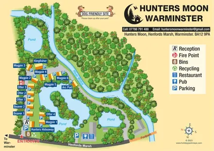
Named lodges, waterside landmarks and clear arrival information at Hunters Moon, Warminster.
 Explore the map ↗
United Kingdom
Woodland-framed Barnsoul map with mixed accommodation, shared facilities and paw-marked walking routes.
Features may come from the sample artwork, its key or published park information. Approximate numbers describe the drawing and may cover only part of a park. They are intended to help you compare map examples. Current facilities and booking information should be checked with the park.
LET’S MAP YOUR PARK
For a map quotation, find your park and draw a rough boundary around it. The area you select helps us work out the design time and price.
Draw your park for a quote ↗Or talk to our map designers
01751 473136