
Three ponds
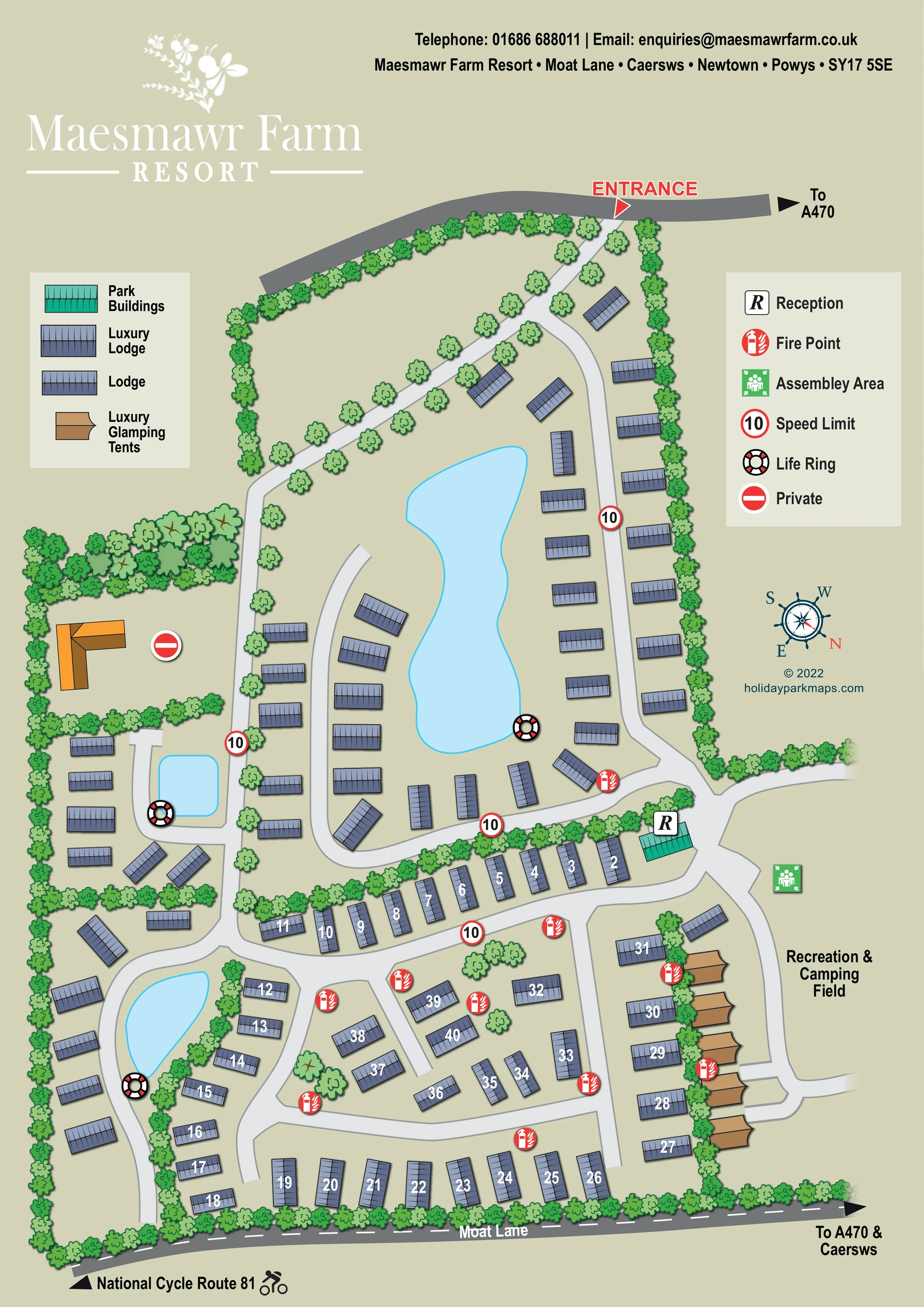
One large elongated pond anchors the upper lodge area; two smaller ponds sit within accommodation groups on the left.
ILLUSTRATED PARK MAP · P205
Maesmawr Farm Resort, Moat Lane, Caersws, Newtown, Powys · United Kingdom
 Enlarge the map ↗
A SENSE OF THE PLACE
Maesmawr Farm Resort offers self-catering lodge holidays near Caersws in Mid Wales. A range of lodge sizes and styles provides options for couples and larger groups.
Selected accommodation includes private hot tubs, with furnished living spaces designed for a countryside break. The map helps guests understand the resort layout and the position of their lodge within the grounds.
LOOK CLOSER
One large elongated pond anchors the upper lodge area; two smaller ponds sit within accommodation groups on the left.
Continuous leafy symbols enclose much of the resort, divide accommodation groups and line the entrance drive. A denser wooded patch appears beside the private building.
A turquoise building with an R marker stands at the principal junction between the upper lodge area, lower accommodation roads and field access.
A large, unpartitioned area on the right of the plan, reached by a curving internal road beside the glamping tents.
A red entrance label and arrow mark access from the road at the top of the page, with an onward direction towards the A470.
Pale curving roads branch from the tree-lined approach into pond-side loops, lodge rows and short spurs, meeting near reception.
A dark-grey road along the lower boundary is named Moat Lane and carries a directional reference towards the A470 and Caersws.
A left-pointing arrow and cyclist pictogram at the lower edge identify the direction to National Cycle Route 81; the route itself is not traced through the resort.
A turquoise building with an R marker stands at the principal junction between the upper lodge area, lower accommodation roads and field access.
A large, unpartitioned area on the right of the plan, reached by a curving internal road beside the glamping tents.
One large elongated pond anchors the upper lodge area; two smaller ponds sit within accommodation groups on the left.
Continuous leafy symbols enclose much of the resort, divide accommodation groups and line the entrance drive. A denser wooded patch appears beside the private building.
A red entrance label and arrow mark access from the road at the top of the page, with an onward direction towards the A470.
Pale curving roads branch from the tree-lined approach into pond-side loops, lodge rows and short spurs, meeting near reception.
A dark-grey road along the lower boundary is named Moat Lane and carries a directional reference towards the A470 and Caersws.
A left-pointing arrow and cyclist pictogram at the lower edge identify the direction to National Cycle Route 81; the route itself is not traced through the resort.
Repeated red extinguisher symbols mark fire points around the lower lodge groups, reception approach and glamping row.
A green assembly symbol is positioned beside the field, close to reception and the adjoining road junction.
Life-ring symbols are shown at the edges of all three depicted ponds.
Red-ringed signs displaying 10 appear at several points on the internal roads.
An orange-brown L-shaped building in a tree-enclosed area on the left is accompanied by the key's Private symbol.
READING THE MAP
This illustrated map of Maesmawr Farm Resort presents a lodge-led countryside retreat near Caersws in Powys, Mid Wales. Its portrait layout brings together pond-side accommodation, landscaped internal roads and a separate glamping row beside an open recreation and camping field. The result is a visitor plan in which water, planting and road shape are as important to orientation as the accommodation labels.
A large elongated pond gives the upper part of the map a clear centrepiece, while two smaller ponds distinguish groups on the left. Blue-grey roof symbols identify lodges, brown tent shapes mark luxury glamping accommodation, and a turquoise reception building stands out at a connecting road junction. The tree-lined entrance is highlighted in red, making the starting point easy to locate within the wider composition.
Two compact keys explain accommodation types and practical visitor symbols. Moat Lane, directions towards the A470 and Caersws, and a reference to National Cycle Route 81 connect the resort plan to its surroundings. White floral branding and a restrained sage background give the page a distinctly rural character without competing with the wayfinding information.
The map uses a largely overhead view to explain an elongated resort enclosed by trees and planted boundaries. Arrival is marked at the top of the page by a red entrance arrow from an external road. A pale, tree-lined drive runs diagonally into the grounds before connecting with the curving accommodation roads. The upper lodge area wraps around a large irregular pond, with units arranged along its eastern side and around the lower connecting loop.
On the left, smaller accommodation groups surround two additional ponds. A private L-shaped building occupies its own planted enclosure nearby. Lower down, the road network becomes a sequence of rows, curved edges and short branching spurs. Many lodges in this part of the map carry white numbers directly on their blue-grey roofs, giving guests a simple way to identify their destination without adding separate label boxes.
Reception is shown as a turquoise building near the junction between the main lodge areas and the field access. To its right, the labelled recreation and camping field remains open rather than being divided into pitches. Five brown luxury glamping tents form a row along its edge, with a strip of trees separating them from adjacent lodges.
The left-hand key distinguishes park buildings, luxury lodges, lodges and luxury glamping tents. The right-hand key explains reception and the practical symbols repeated across the plan: fire points, an assembly area, speed-limit markers, life rings and private access. Life rings accompany each pond, while red fire-point symbols stand out particularly clearly among the lower accommodation groups.
Along the bottom boundary, Moat Lane is drawn as a dark road with dashed markings. Arrows indicate the A470, Caersws and National Cycle Route 81. An ornamental compass, resort header and designer credit complete the single-page composition.
KEEP EXPLORING
Chosen for shared landscapes, accommodation or facilities.
 Explore the map ↗
United Kingdom
Woodland-framed Barnsoul map with mixed accommodation, shared facilities and paw-marked walking routes.
 Explore the map ↗
United Kingdom
A colour-zoned coastal park map with touring areas, woodland trails, ponds and a leisure club.
 Explore the map ↗
United Kingdom
Woodland holiday-park map with named accommodation areas, touring loops and illustrated recreation facilities.
Features may come from the sample artwork, its key or published park information. Approximate numbers describe the drawing and may cover only part of a park. They are intended to help you compare map examples. Current facilities and booking information should be checked with the park.
LET’S MAP YOUR PARK
For a map quotation, find your park and draw a rough boundary around it. The area you select helps us work out the design time and price.
Draw your park for a quote ↗Or talk to our map designers
01751 473136