
Public playing field
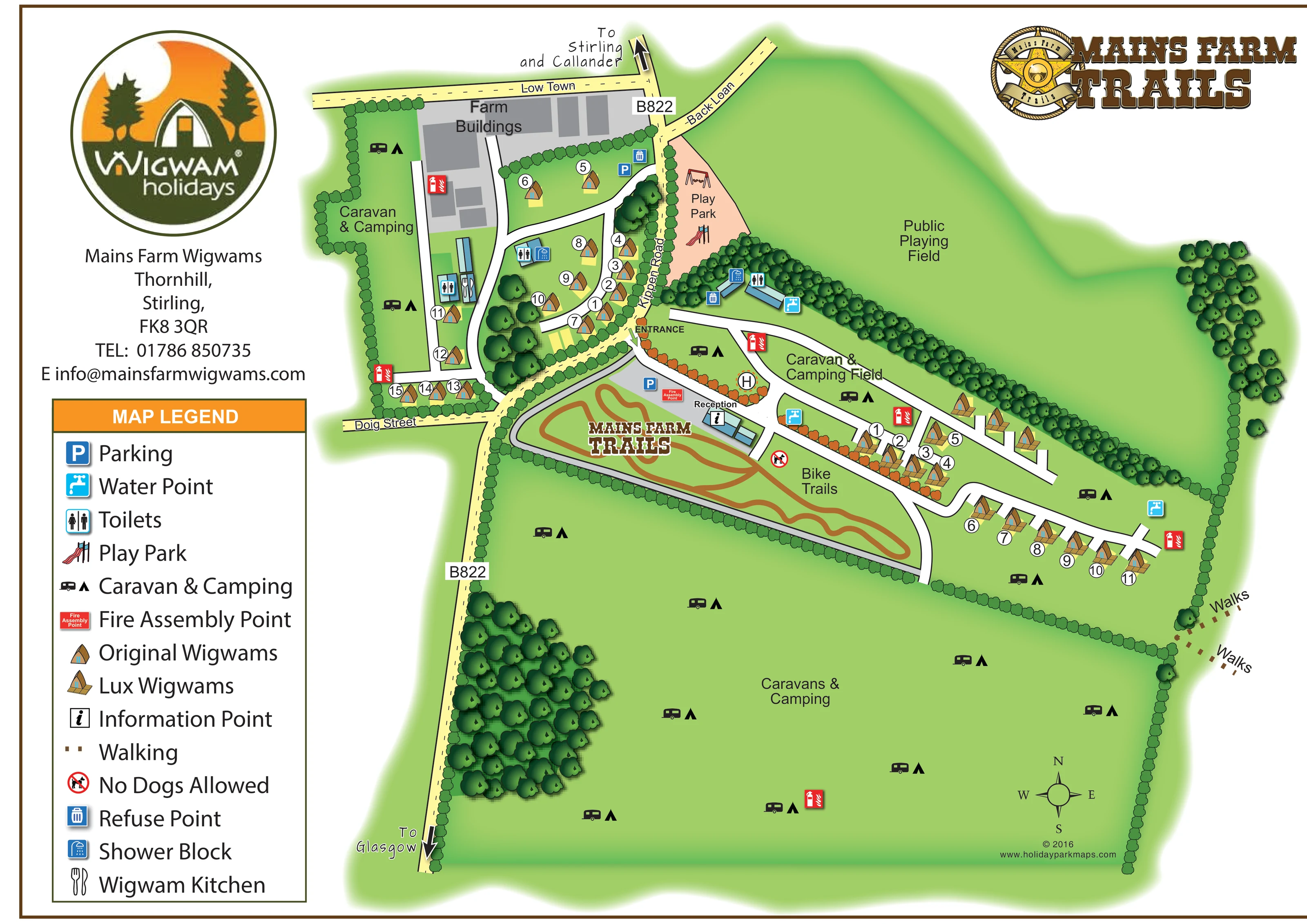
A large open field occupies the upper-right portion of the map, separated from the accommodation by a substantial tree belt.
ILLUSTRATED PARK MAP · P535
Mains Farm Wigwams, Thornhill, Stirling · United Kingdom
 Enlarge the map ↗
A SENSE OF THE PLACE
Mains Farm Wigwams offers glamping near Thornhill and Stirling, close to the Loch Lomond and Trossachs area. Heated wooden cabins look across the Carse of Stirling towards the Fintry Hills.
The site suits families, couples and groups of friends, with walks starting from the grounds. Stirling's historic attractions and the surrounding lochs and hills provide further options for days out.
LOOK CLOSER
A large open field occupies the upper-right portion of the map, separated from the accommodation by a substantial tree belt.
Rounded hedgerows divide fields and cabin groups, while shaded tree clusters mark the western cabin area, the southern corner and the edge of the public playing field.
Reception is labelled beside a small building near the entrance and bike-trail area, with an information symbol.
Blue parking symbols mark an arrival-area parking space and a location near the northern Original Wigwams.
Toilet and shower symbols identify service buildings within the western cabin area and beside the tree belt east of the play park.
The cutlery symbol from the legend is placed at the elongated service building beside the western cabins.
Blue tap symbols occur beside the eastern service buildings, near reception and towards the eastern camping area.
Blue bin symbols mark refuse locations near the northern cabins and eastern service buildings.
Reception is labelled beside a small building near the entrance and bike-trail area, with an information symbol.
Blue parking symbols mark an arrival-area parking space and a location near the northern Original Wigwams.
Toilet and shower symbols identify service buildings within the western cabin area and beside the tree belt east of the play park.
The cutlery symbol from the legend is placed at the elongated service building beside the western cabins.
Blue tap symbols occur beside the eastern service buildings, near reception and towards the eastern camping area.
Blue bin symbols mark refuse locations near the northern cabins and eastern service buildings.
A peach-coloured play area beside Kippen Road contains illustrated swings and a slide.
A large open field occupies the upper-right portion of the map, separated from the accommodation by a substantial tree belt.
A long triangular activity area contains winding brown trail loops and its own Mains Farm Trails lettering.
Two short dotted brown routes leave the eastern boundary and are labelled Walks; their destinations are not detailed.
A group of grey building footprints anchors the north-western part of the plan.
Rounded hedgerows divide fields and cabin groups, while shaded tree clusters mark the western cabin area, the southern corner and the edge of the public playing field.
The entrance is marked on Kippen Road, with the B822, Low Town, Back Loan and Doig Street providing local context. Direction arrows indicate Glasgow and Stirling and Callander.
A labelled red assembly-point marker is shown beside the arrival parking area near reception.
Repeated red fire-extinguisher pictograms appear around the farm, cabin groups and camping fields.
A crossed-out dog symbol appears beside the bike-trail area and is explained in the legend. It should not be read as a current park-wide pet policy.
READING THE MAP
This illustrated map of Mains Farm Wigwams brings a working-farm setting, timber glamping cabins and outdoor recreation together on one landscape-format page. Located at Thornhill near Stirling, the site is shown in relation to the B822 and neighbouring village roads, with clear directions towards Glasgow, Stirling and Callander.
The plan distinguishes Original Wigwams from Lux Wigwams through different miniature cabin illustrations. Compact cabin groups around the farm buildings contrast with longer rows to the east, while broad green fields identify caravan and camping areas without implying a fixed pitch arrangement. Trees and hedges give these different spaces a clear visual structure.
A particularly distinctive element is the Mains Farm Trails area: winding brown bike trails fill a triangular strip beside reception and carry their own branding. A play park, public playing field and walking-route exits extend the outdoor emphasis. The large left-hand legend makes everyday facilities easy to recognise, leaving the main drawing free to explain how accommodation, services and activity areas fit together.
The map places Kippen Road through the centre of the site, linking the entrance to the surrounding B822, Low Town, Back Loan and Doig Street. On the western side, grey farm-building footprints form a substantial northern landmark. Original Wigwams sit in small groups beside curving white lanes, with trees, hedges and a short southern row giving the area a sheltered, compartmentalised appearance. Toilet, shower and kitchen symbols identify nearby service buildings.
East of the entrance, reception and parking occupy the broad end of a triangular recreation area. Brown looping lines depict the bike trails within it, and the Mains Farm Trails name is repeated inside the drawing as well as in the upper-right logo. Beyond this strip, branching white lanes serve rows of Lux Wigwams. Their wider illustrated bases distinguish them from the smaller Original Wigwam symbols. Numbered white circles support cabin finding without turning the whole site into a dense pitch grid.
The upper-right public playing field is separated from the accommodation by a long belt of shaded trees. A peach-coloured play park beside the road includes recognisable swings and slide illustrations. Caravan and camping fields occupy the western edge, central eastern area and much of the lower plan; repeated caravan-and-tent symbols communicate their use rather than specific pitch positions. Water, refuse and fire-equipment markers are distributed through the drawing, with a fire assembly point near arrival parking.
Dotted walking routes leave the eastern boundary. A compass rose, destination arrows and the large pictorial legend complete the wayfinding system. The accompanying enlarged view shows part of this same artwork and its legend, rather than a separate map or additional accommodation area.
KEEP EXPLORING
Chosen for shared landscapes, accommodation or facilities.
 Explore the map ↗
United Kingdom
Woodland-framed Barnsoul map with mixed accommodation, shared facilities and paw-marked walking routes.
 Explore the map ↗
United Kingdom
Woodland park map with mixed pitches, bell tents, lodges and a fishing lake.
 Explore the map ↗
United Kingdom
A colour-zoned coastal park map with touring areas, woodland trails, ponds and a leisure club.
Features may come from the sample artwork, its key or published park information. Approximate numbers describe the drawing and may cover only part of a park. They are intended to help you compare map examples. Current facilities and booking information should be checked with the park.
TAKE A CLOSER LOOK
View the illustrated map in detail or choose a file to download. These are sample maps; contact the park for current visitor information.


LET’S MAP YOUR PARK
For a map quotation, find your park and draw a rough boundary around it. The area you select helps us work out the design time and price.
Draw your park for a quote ↗Or talk to our map designers
01751 473136
 mainsfarm_large.png