
Lakes and connecting watercourse
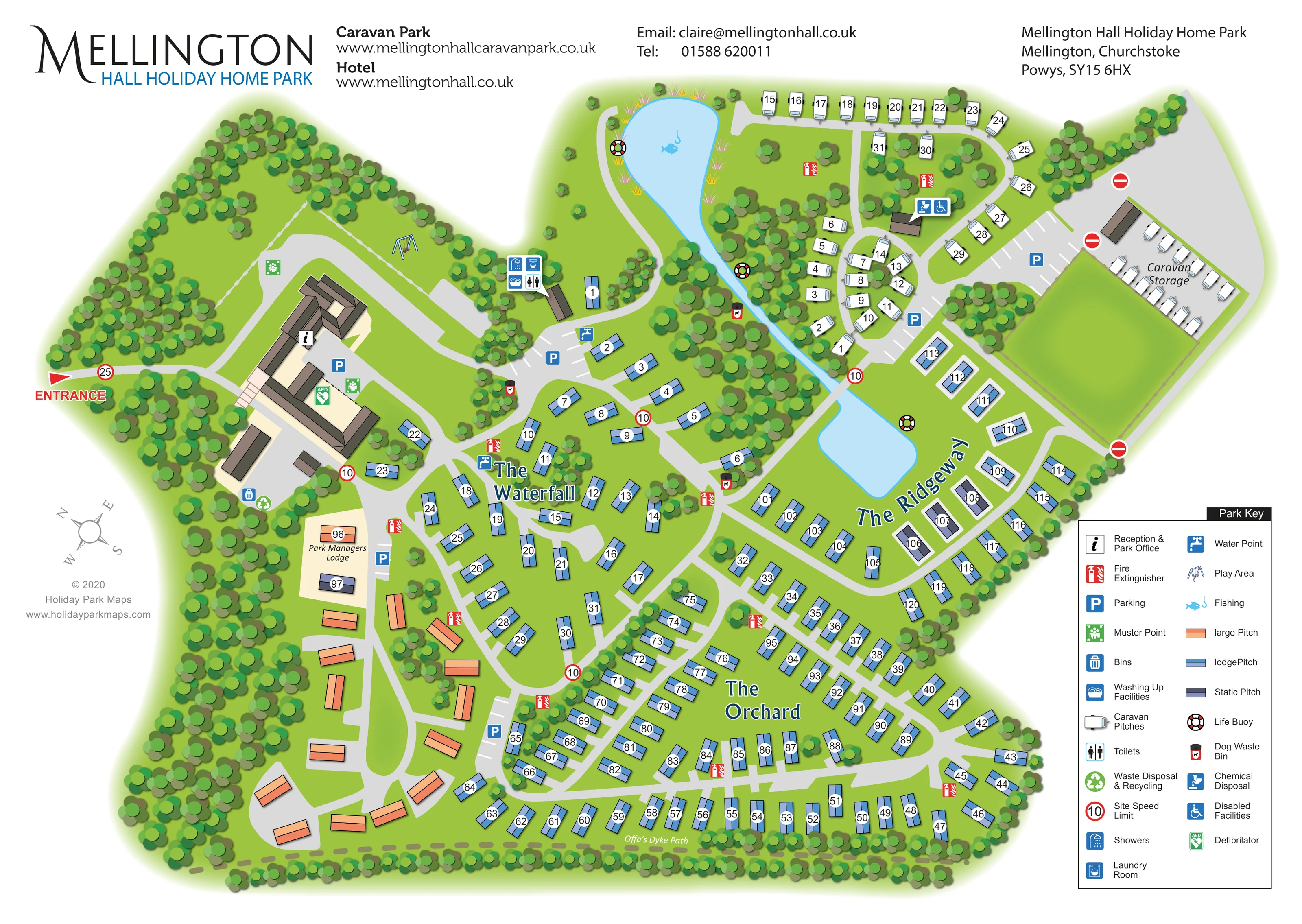
A large irregular northern lake narrows into a watercourse leading to a smaller southern pond, with a road crossing between them.
ILLUSTRATED PARK MAP · P539
Mellington Hall Holiday Home Park, Mellington, Churchstoke, Powys · United Kingdom
 Enlarge the map ↗
A SENSE OF THE PLACE
Mellington Hall Holiday Home Park is set in parkland and farmland on the Powys–Shropshire border. The grounds surround the historic hall, with the Offa's Dyke Path passing through the estate.
Holiday homes and touring pitches provide options for stays, including seasonal touring. Serviced hardstandings overlook the lake and parkland, while walking, cycling and coarse fishing feature among the estate's outdoor activities.
LOOK CLOSER
A large irregular northern lake narrows into a watercourse leading to a smaller southern pond, with a road crossing between them.
Dense tree belts frame the western and southern boundaries, with substantial internal tree groups around the lakes and between accommodation areas.
An information symbol identifies reception within the substantial building complex near the western entrance.
A prominent multi-wing building group with brown roofs, pale courtyards and neighbouring outbuildings anchors the western side of the plan.
Blue parking symbols and white bay markings identify parking beside the main buildings, service areas and accommodation roads.
A swing illustration marks the play area on the wooded lawn north of the main building complex.
A fish-and-hook symbol appears in the larger northern water body.
A separately labelled storage compound occupies the north-eastern edge, with rows of caravans and an adjacent building.
An information symbol identifies reception within the substantial building complex near the western entrance.
A prominent multi-wing building group with brown roofs, pale courtyards and neighbouring outbuildings anchors the western side of the plan.
Blue parking symbols and white bay markings identify parking beside the main buildings, service areas and accommodation roads.
A swing illustration marks the play area on the wooded lawn north of the main building complex.
A fish-and-hook symbol appears in the larger northern water body.
A separately labelled storage compound occupies the north-eastern edge, with rows of caravans and an adjacent building.
A cluster of symbols beside a building between the hall and northern lake identifies toilets, showers, laundry and washing-up facilities.
The dishwashing symbol is included in the service-building cluster west of the lake.
Chemical-disposal symbols mark points near the central accommodation roads and at the touring-area service building.
A wheelchair symbol is paired with the chemical-disposal marker at the touring-area service building; the key describes it as disabled facilities.
Blue tap symbols identify water points near parking and accommodation junctions.
Waste and recycling symbols are grouped beside the main building area.
Several black-and-red dog waste symbols appear beside wooded routes and water-side junctions.
Red extinguisher markers are distributed through the touring and holiday-home areas.
Green assembly-point symbols appear near the hall and on the lawn to its north.
A green AED symbol is placed beside the main building complex.
Red-and-white life-buoy symbols identify several positions around the connected water features.
A large irregular northern lake narrows into a watercourse leading to a smaller southern pond, with a road crossing between them.
Dense tree belts frame the western and southern boundaries, with substantial internal tree groups around the lakes and between accommodation areas.
Large curved labels divide the holiday-home layout into three recognisable areas. The Waterfall is a section name, not evidence of an illustrated waterfall.
A labelled dashed route follows the southern tree-lined boundary.
The western entrance leads towards reception and branches into interconnected loops serving the accommodation, water-side areas and caravan storage.
Red-ringed speed markers and no-entry symbols are incorporated into the road layout, including around the storage access.
A separately labelled lodge stands south of the main buildings beside the western accommodation road.
READING THE MAP
This illustrated map of Mellington Hall Holiday Home Park brings together a wooded estate setting, lakeside touring pitches and three named holiday-home areas in one clear plan. Located at Mellington, near Churchstoke in Powys, the park is presented around its distinctive hall complex, with the entrance and reception on the western side and accommodation roads extending through the grounds.
The artwork gives particular attention to the landscape. Dense tree belts enclose the site, smaller groups break up the accommodation rows, and two connected water features provide an immediately recognisable landmark. The Waterfall, The Orchard and The Ridgeway are labelled prominently, helping visitors relate individual pitch numbers to larger areas of the park.
Blue, slate and orange accommodation symbols distinguish the pitch categories, while white caravan illustrations identify the touring area. A separate storage compound, service buildings, parking, play area and fishing symbol add practical detail. Along the southern boundary, the labelled Offa's Dyke Path connects the park plan with the estate's wider walking setting. A comprehensive key keeps these different layers of information together without crowding the main routes.
The plan begins with a bold entrance arrow on the western edge, where the access road leads towards a substantial group of hall buildings and the reception symbol. Roof planes, courtyard surfaces and nearby parking make this arrival area visually different from the simpler accommodation symbols. A play-area swing stands on the wooded lawn to the north, while waste and recycling markers and an AED symbol appear close to the building complex.
From this arrival hub, pale-grey roads branch into a series of linked loops. Orange large-pitch symbols are concentrated along the western and south-western routes, including the road beside the labelled Park Managers Lodge. Blue lodge pitches occupy most of the central and southern plan, arranged around bends and short side roads rather than a single rigid grid. The Waterfall and The Orchard labels identify these areas; The Ridgeway curves around the smaller pond and eastern accommodation roads. A few slate-coloured static pitches provide a further category within the layout.
The northern lake narrows into a watercourse leading to the southern pond. A road crosses this connection, and tree groups partly screen both banks. Fishing and life-buoy symbols give the water practical significance as well as visual prominence. Beyond it, white caravan symbols form the touring area, with nearby service facilities and parking. The north-eastern storage compound is separately labelled and illustrated with rows of caravans.
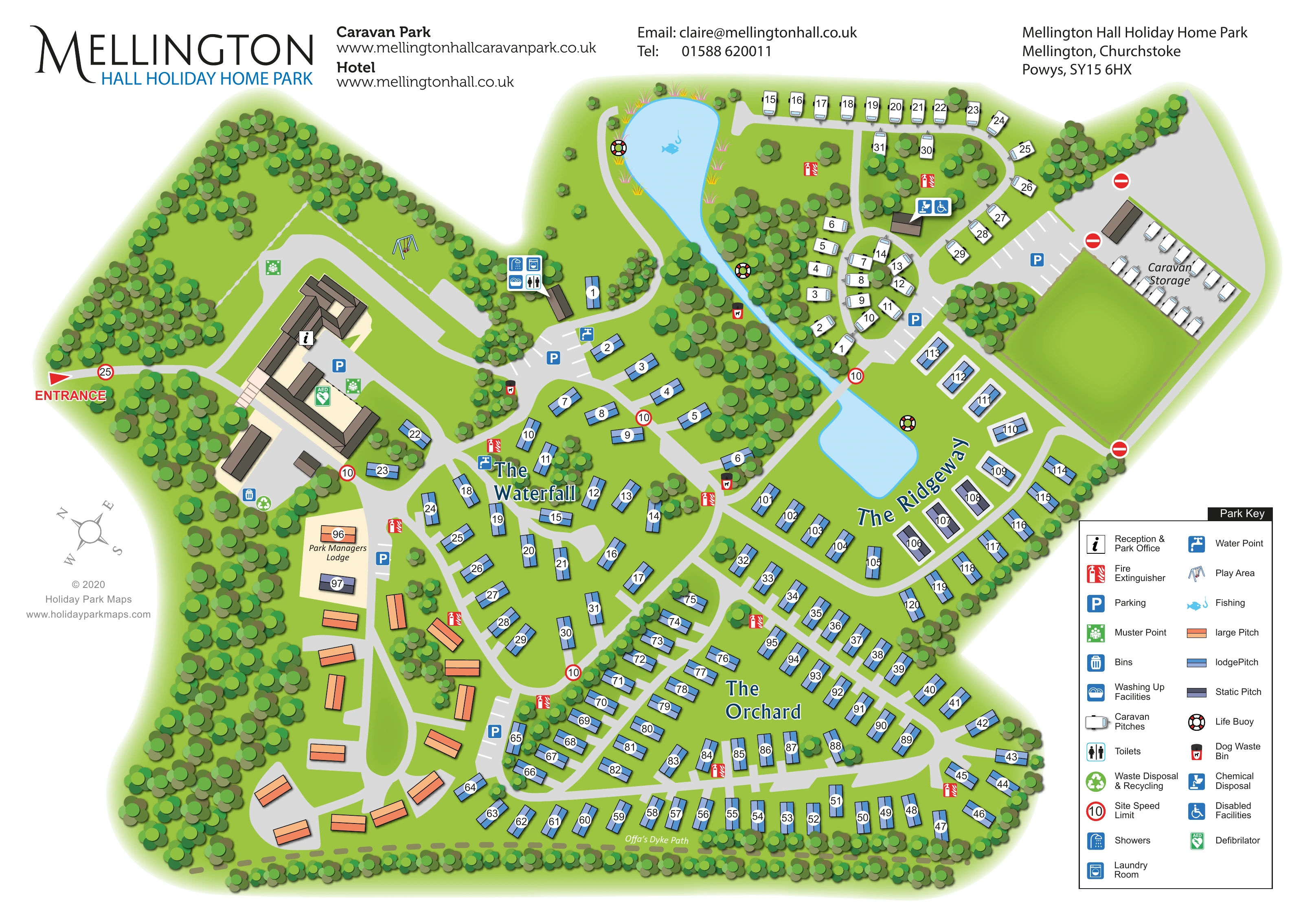
Toilets, showers, laundry, washing-up facilities, water points and chemical disposal are identified through pictograms, alongside repeated fire-equipment markers and dog waste bins. The lower-right key explains these symbols and the accommodation colours. Offa's Dyke Path follows the southern tree belt. The accompanying enlarged detail repeats part of The Ridgeway and the key, making the legend easier to read without adding a separate map variant.
KEEP EXPLORING
Chosen for shared landscapes, accommodation or facilities.
 Explore the map ↗
United Kingdom
Woodland park map with mixed pitches, bell tents, lodges and a fishing lake.
 Explore the map ↗
United Kingdom
Illustrated lakeside park plan with numbered holiday units, leisure buildings and a looping Woodland Walk.
 Explore the map ↗
United Kingdom
Illustrated caravan park plan with woodland and riverside walks, fishing pools and wildlife panels.
Features may come from the sample artwork, its key or published park information. Approximate numbers describe the drawing and may cover only part of a park. They are intended to help you compare map examples. Current facilities and booking information should be checked with the park.
TAKE A CLOSER LOOK
View the illustrated map in detail or choose a file to download. These are sample maps; contact the park for current visitor information.


LET’S MAP YOUR PARK
For a map quotation, find your park and draw a rough boundary around it. The area you select helps us work out the design time and price.
Draw your park for a quote ↗Or talk to our map designers
01751 473136
 mellingtonsolo_large.png