
Central open green
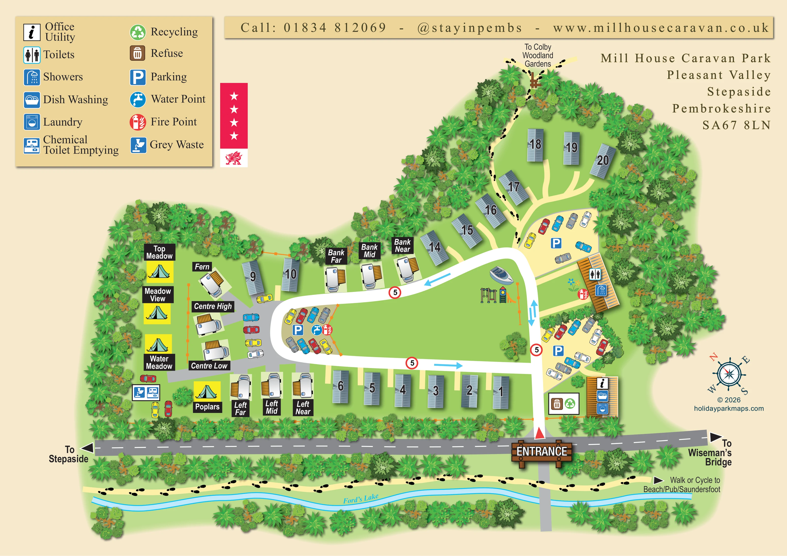
A large grassed space occupies the middle of the loop, with play equipment, a boat-shaped illustration and short sections of orange fencing.
ILLUSTRATED PARK MAP · P216
Mill House Caravan Park, Pleasant Valley, Stepaside, Pembrokeshire · United Kingdom
 Enlarge the map ↗
A SENSE OF THE PLACE
Mill House Caravan Park is a small site at Stepaside near Saundersfoot in Pembrokeshire. Static caravan hire, touring pitches and a small tent area provide different ways to stay.
A level walking and cycling route follows the former miners' track towards the coast. The park welcomes dogs under its site rules, and the map helps visitors understand the accommodation layout before exploring nearby beaches and towns.
LOOK CLOSER
A large grassed space occupies the middle of the loop, with play equipment, a boat-shaped illustration and short sections of orange fencing.
Dense, overlapping tree and shrub illustrations frame the park, especially the western edge and upper accommodation area.
A narrow, winding blue watercourse below the roadside walking route is labelled Ford's Lake.
A small ochre-roofed building beside the entrance carries the office/utility information symbol.
Dish washing and laundry symbols are placed on the entrance-side office/utility building.
A separate long building on the eastern side of the central green is marked with toilet and shower symbols.
Three signed parking pockets sit beside the central loop and eastern entrance route; additional cars are illustrated near accommodation.
A blue tap symbol marks a water point at the parking pocket on the western bend of the loop.
A small ochre-roofed building beside the entrance carries the office/utility information symbol.
Dish washing and laundry symbols are placed on the entrance-side office/utility building.
A separate long building on the eastern side of the central green is marked with toilet and shower symbols.
Three signed parking pockets sit beside the central loop and eastern entrance route; additional cars are illustrated near accommodation.
A blue tap symbol marks a water point at the parking pocket on the western bend of the loop.
Red fire-point symbols appear beside the western parking pocket and the toilet/shower building.
Paired refuse and recycling symbols mark a collection area near the entrance and office/utility building.
Paired service symbols identify a disposal point in the lower western touring and camping area.
Swings and a small climbing tower with a slide are illustrated on the central green.
A large grassed space occupies the middle of the loop, with play equipment, a boat-shaped illustration and short sections of orange fencing.
Dense, overlapping tree and shrub illustrations frame the park, especially the western edge and upper accommodation area.
A narrow, winding blue watercourse below the roadside walking route is labelled Ford's Lake.
A timber-style ENTRANCE sign and red triangular marker identify access from the road along the lower edge.
White roads wrap around the central green. Blue arrows show circulation along the loop and opposing directions on the entrance stem; red-ringed 5 signs recur along the route.
The grey road across the lower edge has directional arrows to Stepaside on the left and Wiseman's Bridge on the right.
A pale path with black footprint symbols follows Ford's Lake and is labelled Walk or Cycle to Beach/Pub/Saundersfoot.
A footprint-marked path runs beside the upper caravans through the trees to an illustrated stile or gate, with an onward direction to Colby Woodland Gardens.
READING THE MAP
This illustrated map presents Mill House Caravan Park in Pleasant Valley, Stepaside, Pembrokeshire, as a small, tree-framed site with several ways to stay. Numbered static caravans, named touring pitches and clearly marked camping spots are arranged around a broad central green, giving visitors an immediate sense of the park's organisation without turning the page into a technical site plan.
The entrance is a strong visual anchor, marked by a timber-style sign beside the road towards Stepaside and Wiseman's Bridge. From there, white internal roads lead past parking and service buildings and around the green. A large pictogram legend helps visitors locate practical facilities, including toilets, showers, laundry, dish washing and touring waste points.
The setting is an important part of the illustration. Dense tree borders surround the accommodation, while Ford's Lake and a footprint-marked walking and cycling route run along the lower edge. A second path points towards Colby Woodland Gardens. Together, these details connect the accommodation layout with the surrounding valley and the routes visitors may use to explore towards the coast.
The single landscape-format plan is built around an irregular loop of white internal road enclosing a large green. Blue arrows indicate circulation along its upper and lower sides, while the entrance stem has arrows in both directions. Repeated red-ringed 5 signs provide an additional visual cue. The entrance meets the grey public road at the bottom of the page, where large destination arrows point towards Stepaside and Wiseman's Bridge.
Accommodation is differentiated through both illustration and labelling. Blue-grey static caravans carry large outlined numbers and occupy the lower boundary, a short western group and the upper wooded arm. Touring pitches on the left use white caravan illustrations with ochre side structures and black name panels, including the Bank, Centre and Left groups. Yellow panels with turquoise tents distinguish the named camping locations of Top Meadow, Meadow View, Water Meadow and Poplars.
Practical facilities are concentrated in recognisable clusters. Near the entrance, the office/utility building carries dish washing and laundry symbols, with refuse and recycling nearby. Further up the eastern side, a separate building is marked for toilets and showers. Parking pockets appear beside this approach and at the western bend, where water and fire-point symbols are also shown. Chemical toilet emptying and grey waste are marked in the lower western area. Swings, a slide tower and a boat-shaped illustration occupy part of the central green.
Beyond the accommodation, layered trees define the boundaries. A footprint-marked path follows the blue watercourse labelled Ford's Lake towards the beach, pub and Saundersfoot; another climbs through the upper trees towards Colby Woodland Gardens. The page is completed by a two-column legend, top contact strip, park address, Welsh dragon motif and nautical-style compass.
KEEP EXPLORING
Chosen for shared landscapes, accommodation or facilities.
 Explore the map ↗
United Kingdom
Woodland holiday homes, named camping fields and farm buildings on a colour-coded Nether Wasdale park map.
 Explore the map ↗
United Kingdom
Illustrated caravan park plan with woodland and riverside walks, fishing pools and wildlife panels.
 Explore the map ↗
United Kingdom
A lakeside holiday-park and fishery map with numbered accommodation, fishing positions and clearly grouped visitor services.
Features may come from the sample artwork, its key or published park information. Approximate numbers describe the drawing and may cover only part of a park. They are intended to help you compare map examples. Current facilities and booking information should be checked with the park.
LET’S MAP YOUR PARK
For a map quotation, find your park and draw a rough boundary around it. The area you select helps us work out the design time and price.
Draw your park for a quote ↗Or talk to our map designers
01751 473136