
Lundy View
A softly outlined green area named Lundy View lies west of the central camping fields, near a coastpath direction arrow.
ILLUSTRATED PARK MAP · P228
North Morte Farm, Mortehoe, Woolacombe, N Devon · United Kingdom
 Enlarge the map ↗
A SENSE OF THE PLACE
North Morte Farm is a family-run caravan and camping park at Mortehoe in North Devon. Coastal countryside and direct access to the South West Coast Path are defining features of its setting.
The touring field is separate from the camping areas and has gravel pitches with electricity. Tent camping is on natural, sometimes sloping ground without electric connections. Showers, toilets and waste facilities support stays.
LOOK CLOSER
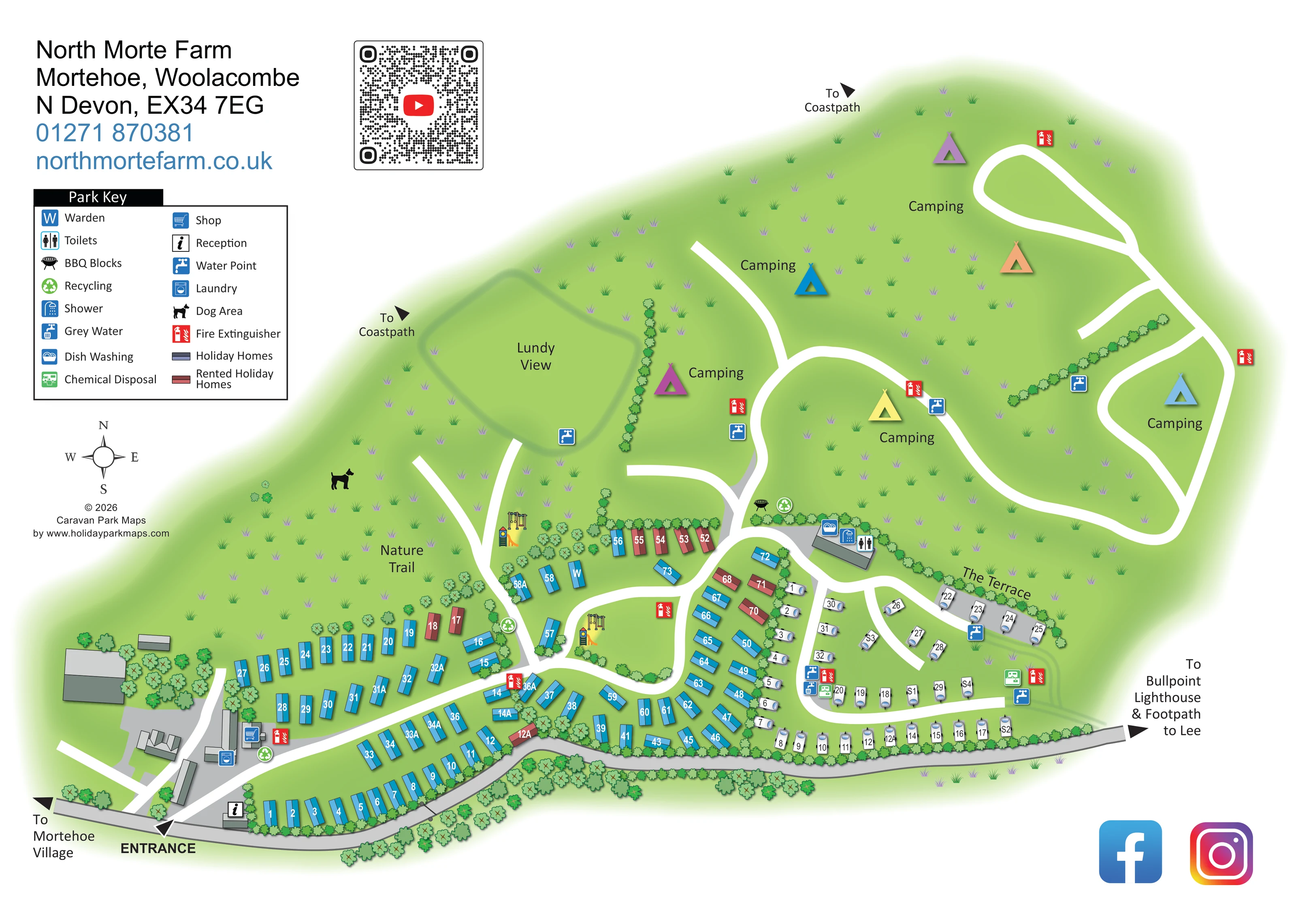
A softly outlined green area named Lundy View lies west of the central camping fields, near a coastpath direction arrow.
Large green fields dominate the upper plan, with sparse grass motifs and scattered camping labels rather than individually drawn tent pitches.
Repeated tree and shrub symbols frame the perimeter, divide accommodation groups and screen sections of the touring area.
The Terrace names the curved upper edge of the touring area, where white caravan symbols sit on a grey strip below a hedge.
An information symbol marks reception immediately inside the entrance beside the lower boundary road.
A shopping-trolley symbol identifies the shop within the building cluster west of the holiday-home rows.
A W-marked unit is shown near the central-western holiday homes and the approach to the camping fields.
Grouped symbols identify toilets, showers and dish washing at the central amenity building between the camping fields and touring area.
An information symbol marks reception immediately inside the entrance beside the lower boundary road.
A shopping-trolley symbol identifies the shop within the building cluster west of the holiday-home rows.
A W-marked unit is shown near the central-western holiday homes and the approach to the camping fields.
Grouped symbols identify toilets, showers and dish washing at the central amenity building between the camping fields and touring area.
A washing-machine symbol marks laundry facilities in the western service-building cluster.
Blue tap symbols are distributed around the camping fields, Lundy View and the touring area.
Grey-water and chemical-disposal symbols appear at service points within the touring area.
Green recycling symbols mark several locations beside internal roads and amenity areas.
A barbecue symbol appears beside the central junction just north-west of the main washroom building.
Red extinguisher symbols are placed throughout the holiday-home, touring and camping areas.
Two small illustrated groups of swings and slide equipment appear beside the central holiday-home areas. They are visible in the artwork but are not separate entries in the key.
A black dog silhouette identifies an area west of the camping approach, near the Nature Trail label.
The Nature Trail is labelled in the grassy western area above the main building cluster; the map does not set out a detailed signed trail itinerary.
A softly outlined green area named Lundy View lies west of the central camping fields, near a coastpath direction arrow.
Large green fields dominate the upper plan, with sparse grass motifs and scattered camping labels rather than individually drawn tent pitches.
Repeated tree and shrub symbols frame the perimeter, divide accommodation groups and screen sections of the touring area.
The entrance is clearly labelled at the lower-left edge, where the internal road branches from the grey boundary road beside reception.
Broad white routes branch through the holiday homes and continue into sweeping loops across the camping fields; grey areas distinguish the boundary road and selected hardstanding or service spaces.
Two outward arrows on the upper and western sides are labelled To Coastpath.
A left-pointing arrow on the lower boundary road indicates Mortehoe Village.
The right-hand end of the boundary road carries an outward arrow naming Bullpoint Lighthouse and the footpath to Lee.
The Terrace names the curved upper edge of the touring area, where white caravan symbols sit on a grey strip below a hedge.
READING THE MAP
This illustrated map of North Morte Farm brings together holiday homes, touring pitches and open camping fields in a coastal North Devon setting. The park is at Mortehoe, near Woolacombe, and the artwork connects its internal layout with directions to the coastpath, Mortehoe Village, Bullpoint Lighthouse and the footpath to Lee.
The composition makes the different accommodation areas immediately recognisable. Blue holiday homes and red rented homes follow the curved roads across the lower part of the plan, while white caravan symbols define a separate touring area on the right. Above them, broad green camping fields are crossed by sweeping white access routes and marked with colourful tent illustrations.
Practical information is woven into this landscape rather than confined to the key. Reception is shown at the entrance, with the shop and laundry nearby, while water points, washroom facilities, recycling and waste services appear where visitors need to find them. Named areas such as Lundy View, The Terrace and the Nature Trail give the map a distinct sense of place. The result is a useful sample for a mixed-accommodation park where open countryside and everyday visitor navigation need equal attention.
The plan is arranged around an entrance on the lower-left boundary road. Reception sits beside this arrival point, and a small cluster of grey-roofed buildings nearby carries the shop and laundry symbols. From here, broad white internal routes branch through the holiday-home areas and towards the touring pitches and camping fields.
Holiday homes are illustrated as slim, two-tone rectangles, angled to follow curved roads and landscaped pockets. White numbers identify the individual units. Most homes are blue, while rented holiday homes are red, creating a clear distinction without changing the overall drawing style. Small groups of illustrated swings and slides appear in two central locations, and a W-marked unit identifies the warden.
On the right, white caravan pictograms define the touring area. Its upper curved row is named The Terrace and sits beneath a hedge, while further rows follow the lower road and internal lanes. Water, grey-water and chemical-disposal symbols provide useful service references within this section.
A grey-roofed amenity building at the transition to the camping fields is marked for toilets, showers and dish washing. Nearby barbecue and recycling symbols add detail at the main junction. Beyond it, large green fields fill much of the upper page. Their white access routes form broad loops and branches, while coloured tents and Camping labels communicate land use without suggesting a fixed pitch count.
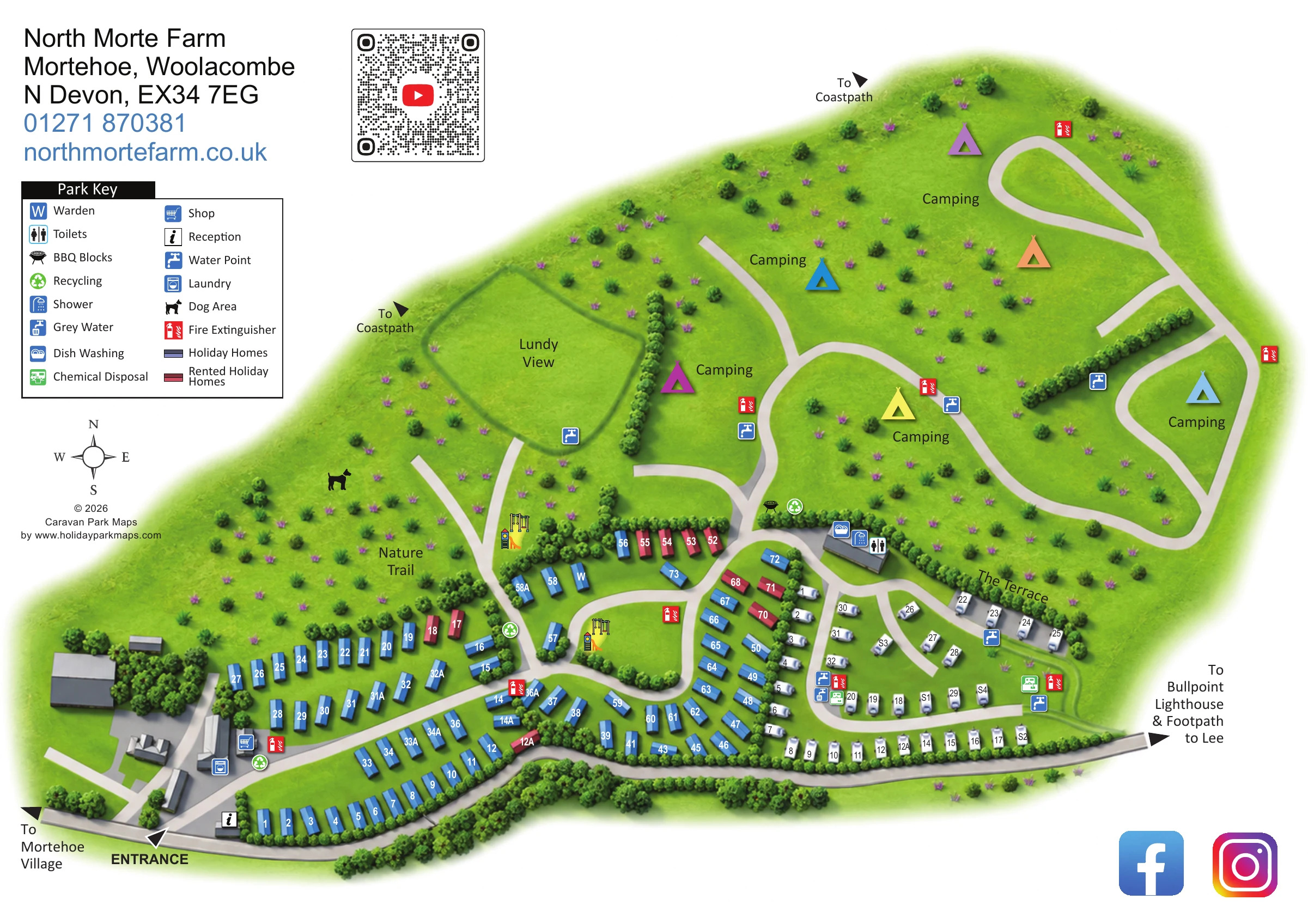
To the west are Lundy View, the Nature Trail label and a dog-area symbol. Trees and hedges soften the developed areas and delineate selected boundaries. Outward arrows identify the coastpath and local destinations. A boxed key, compass, contact heading and video QR code occupy the left-hand white space. The enlarged detail view shows the same artwork, clarifying the key and western landscape rather than introducing another site section.
 Enlarge this map ↗
KEEP EXPLORING
Chosen for shared landscapes, accommodation or facilities.
 Explore the map ↗
United Kingdom
Tree-framed mixed-accommodation park map with two entrances, touring loops and a clearly illustrated social hub.
 Explore the map ↗
United Kingdom
A colour-zoned coastal park map with touring areas, woodland trails, ponds and a leisure club.
 Explore the map ↗
United Kingdom
Coastal touring-park plan with three named fields, four pitch categories and lagoon-side walking connections.
Features may come from the sample artwork, its key or published park information. Approximate numbers describe the drawing and may cover only part of a park. They are intended to help you compare map examples. Current facilities and booking information should be checked with the park.
TAKE A CLOSER LOOK
View the illustrated map in detail or choose a file to download. These are sample maps; contact the park for current visitor information.

LET’S MAP YOUR PARK
For a map quotation, find your park and draw a rough boundary around it. The area you select helps us work out the design time and price.
Draw your park for a quote ↗Or talk to our map designers
01751 473136