
River Rother
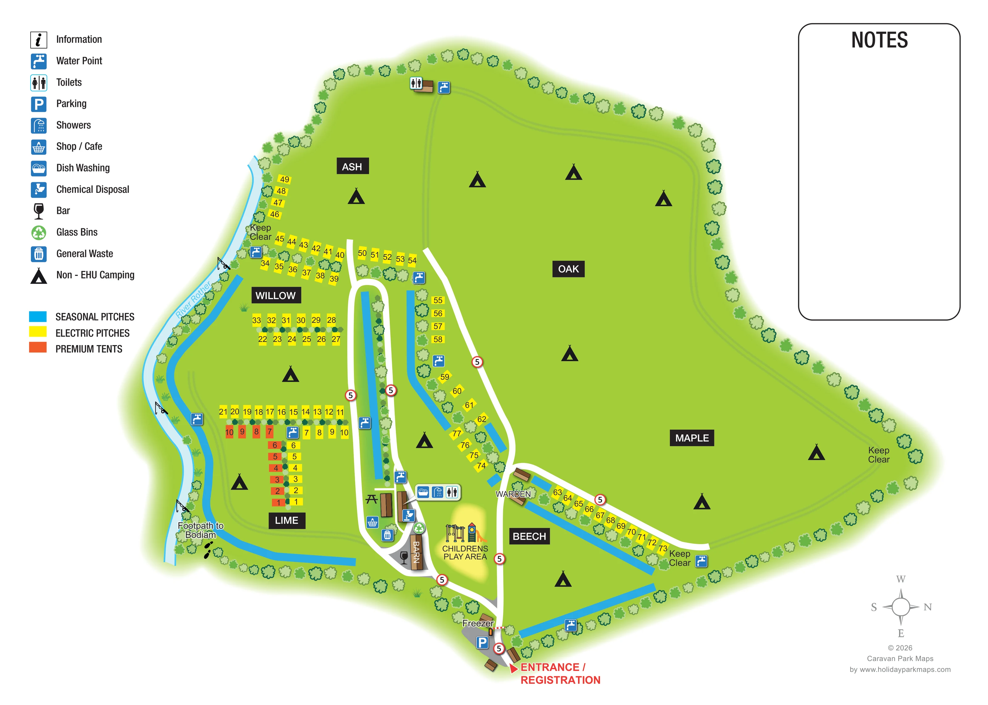
A pale blue, cyan-edged river curves along the left-hand boundary of the artwork.
ILLUSTRATED PARK MAP · P240
Junction Road, Bodiam, East Sussex · United Kingdom
 Enlarge the map ↗
A SENSE OF THE PLACE
Park Farm Caravan & Camp Site is based at Junction Road, Bodiam, East Sussex. This is a family-run campsite on farmland near the East Sussex–Kent boundary. Tents, campervans, motorhomes and caravans are welcome. Non-electric camping allows flexible pitch choice; electric pitches can be reserved subject to availability.
The map brings the site layout and its access routes together in one view, providing a reference for understanding the arrangement of the grounds.
LOOK CLOSER
A pale blue, cyan-edged river curves along the left-hand boundary of the artwork.
Fishing-rod illustrations mark several positions along the River Rother; the artwork does not specify fishing arrangements.
Ash, Oak, Maple, Willow, Lime and Beech divide the grounds into recognisable named areas.
Repeated rounded tree crowns frame the perimeter and separate many pitch rows, with smaller hedge-like planting between compact pitch groups.
A red arrow and prominent red label identify arrival at the bottom of the plan.
A striped barrier crosses the entrance lane beside a grey parking apron and blue parking symbol.
White lanes branch from the entrance, loop around the central service area and extend between pitch rows; faint paired green lines trace routes around the open fields.
Repeated red-ringed '5' signs appear along the lanes, with 'Keep Clear' labels at several field-edge locations.
A red arrow and prominent red label identify arrival at the bottom of the plan.
A striped barrier crosses the entrance lane beside a grey parking apron and blue parking symbol.
White lanes branch from the entrance, loop around the central service area and extend between pitch rows; faint paired green lines trace routes around the open fields.
Repeated red-ringed '5' signs appear along the lanes, with 'Keep Clear' labels at several field-edge locations.
A labelled departure point with footprint symbols sits beside the river at the lower-left edge.
A pale blue, cyan-edged river curves along the left-hand boundary of the artwork.
Fishing-rod illustrations mark several positions along the River Rother; the artwork does not specify fishing arrangements.
Ash, Oak, Maple, Willow, Lime and Beech divide the grounds into recognisable named areas.
Repeated rounded tree crowns frame the perimeter and separate many pitch rows, with smaller hedge-like planting between compact pitch groups.
The central service cluster is marked with toilet and shower symbols. A separate toilet building appears at the upper edge of the fields.
A dish-washing symbol is grouped with the central shower and toilet facilities.
Blue tap symbols are distributed around the riverside pitches, central lanes, field edges and entrance-side camping area.
A chemical-disposal symbol marks a position beside the central facilities.
General waste and green glass-recycling symbols appear within the central amenity cluster.
A basket symbol, identified as Shop / Cafe in the legend, is placed beside a central building.
A brown-roofed building labelled Barn has a black wine-glass bar symbol beside it.
A picnic-table illustration sits beside the central shop and service buildings.
A yellow-highlighted area beside the Barn contains illustrated swings and a slide.
The Warden label identifies small buildings near the junction between the central lane and the Maple pitch run.
A freezer is labelled immediately beside the entrance barrier and parking area.
An information icon is included in the key, but no corresponding position is clearly marked on the plan.
READING THE MAP
This map of Park Farm Caravan & Camp Site in Bodiam, East Sussex, brings a riverside campsite into one illustrated view. Its main organising idea is the contrast between broad open camping fields and smaller, clearly marked pitch groups. Ash, Oak, Maple, Willow, Lime and Beech are named on bold black panels, giving visitors recognisable destinations across the grounds.
Yellow electric pitches, orange premium tent positions and cyan seasonal strips make the accommodation areas easy to distinguish without filling the plan with individual caravan drawings. The River Rother curves along one edge, accompanied by fishing illustrations and a labelled footpath towards Bodiam. At the entrance, a red arrival marker leads into white internal lanes connecting the camping areas with the central facilities.
The artwork also gives practical prominence to the Barn and bar, shop / café, washing facilities and children's play area. A vertical symbol key and a generous Notes panel sit outside the main plan, allowing the landscape to remain the focus while retaining space for visitor information.
The plan begins at the lower edge with a conspicuous red Entrance / Registration label. Nearby are a parking apron, striped barrier and labelled freezer. From here, white access lanes lead into the site and divide around the central buildings, with one narrow loop extending between tree-lined pitch strips. Red-ringed '5' signs punctuate these lanes, while lighter paired green lines trace routes through the larger camping fields.
Willow and Lime, on the river side of the drawing, contain the most compact pitch arrangements. Yellow electric positions form short parallel rows and boundary runs; orange premium tent positions create an L-shaped group in Lime. Longer yellow runs continue towards Ash and along the Maple edge. Cyan seasonal strips follow the river, central corridor and Beech boundaries. Black tent symbols identify open non-electric camping areas rather than individual tent locations.
The central amenity group includes symbols for dish washing, showers, toilets, chemical disposal, general waste and glass recycling. The shop / café is marked nearby, and a wine-glass symbol identifies the bar beside the Barn. A picnic table adds another recognisable landmark. Across the lane, the children's play area is highlighted in yellow and illustrated with swings and a slide; the warden location sits close to the adjoining pitch junction. Further toilets appear at the upper field edge, with water points distributed throughout the grounds.
Along the left boundary, the River Rother is drawn in pale blue with fishing-rod motifs and a footprint-marked footpath to Bodiam. Rounded trees frame the site and divide pitch groups. The single-page composition is completed by a left-hand key, an empty Notes panel and a compass showing north towards the right.
KEEP EXPLORING
Chosen for shared landscapes, accommodation or facilities.
 Explore the map ↗
United Kingdom
Woodland park map with mixed pitches, bell tents, lodges and a fishing lake.
 Explore the map ↗
United Kingdom
Illustrated camping and touring map with fishing lakes, dog areas and colour-coded pitches.
 Explore the map ↗
United Kingdom
Riverside touring-park map with orchard planting, labelled pitches and an integrated local approach.
Features may come from the sample artwork, its key or published park information. Approximate numbers describe the drawing and may cover only part of a park. They are intended to help you compare map examples. Current facilities and booking information should be checked with the park.
TAKE A CLOSER LOOK
View the illustrated map in detail or choose a file to download. These are sample maps; contact the park for current visitor information.

LET’S MAP YOUR PARK
For a map quotation, find your park and draw a rough boundary around it. The area you select helps us work out the design time and price.
Draw your park for a quote ↗Or talk to our map designers
01751 473136
 bindergrass_Page_1.png