
River Teme
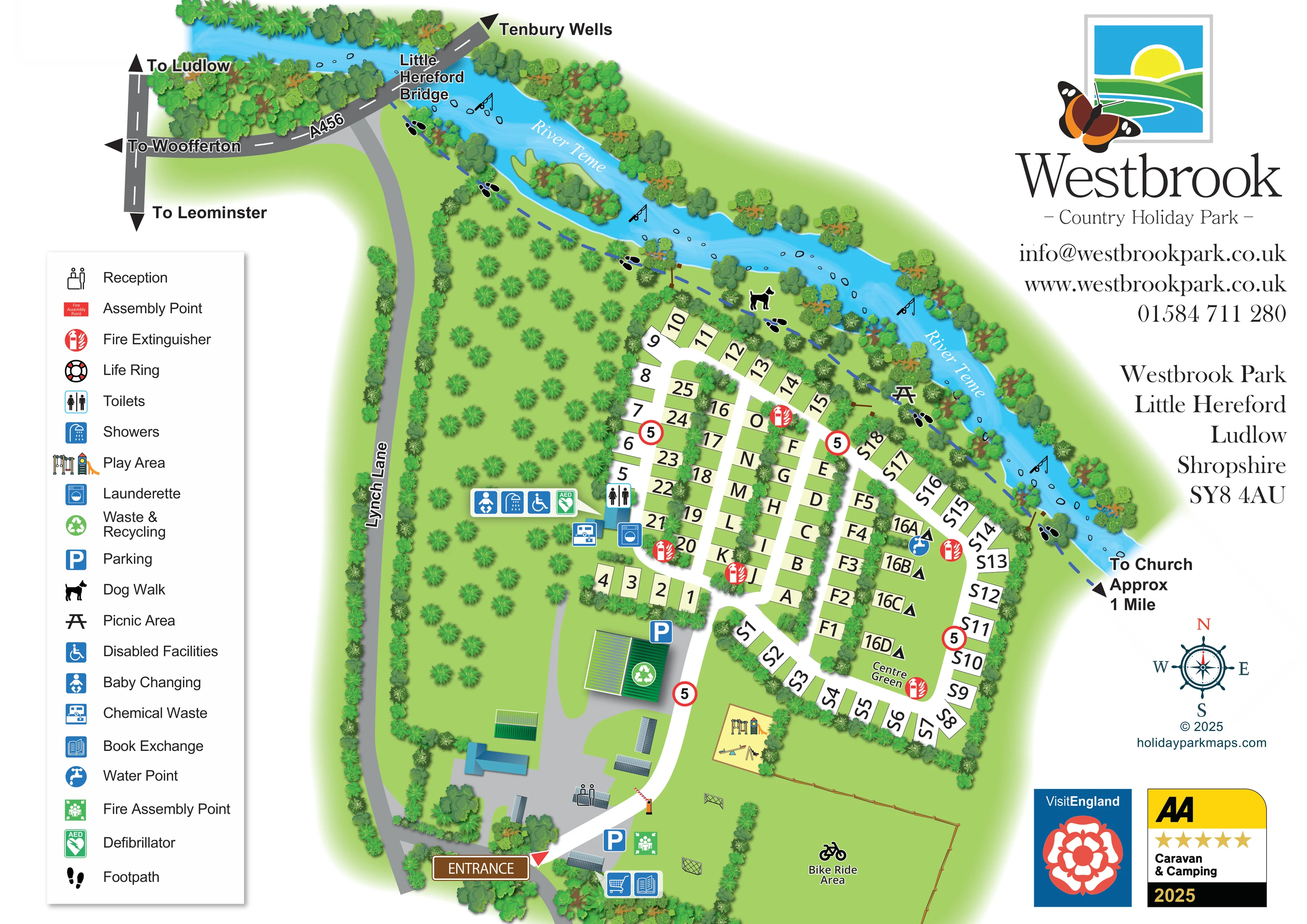
The curving river forms the upper and right-hand landscape edge, with tree-lined banks, stones and a wooded island.
ILLUSTRATED PARK MAP · P359
Westbrook Park, Little Hereford, Ludlow, Shropshire · United Kingdom
 Enlarge the map ↗
A SENSE OF THE PLACE
Westbrook Park is set in an orchard beside the River Teme at Little Hereford near Ludlow. Riverside pitches and natural habitats give the grounds a strong countryside character.
Fully serviced grass and gravel touring pitches are complemented by children's play, a football pitch and a grass bike track. The map helps guests find their way around the orchard, shared facilities and riverbank areas.
LOOK CLOSER
The curving river forms the upper and right-hand landscape edge, with tree-lined banks, stones and a wooded island.
Regularly spaced trees fill a broad orchard west of the accommodation, while denser planting lines the lanes, boundaries and riverbank.
A named open green occupies the interior of the eastern pitch loop and includes the small tent-marked group.
Reception is marked within the arrival and building cluster just inside the entrance.
Blue parking symbols identify spaces near the entrance and beside the larger green-roofed service building.
A grouped washroom facility cluster sits at the western edge of the pitches, next to the orchard. The symbols identify facilities rather than guaranteeing accessibility throughout the site.
A washing-machine symbol marks the launderette beside the washroom building.
A chemical-waste symbol is positioned immediately west of the main washroom cluster.
Reception is marked within the arrival and building cluster just inside the entrance.
Blue parking symbols identify spaces near the entrance and beside the larger green-roofed service building.
A grouped washroom facility cluster sits at the western edge of the pitches, next to the orchard. The symbols identify facilities rather than guaranteeing accessibility throughout the site.
A washing-machine symbol marks the launderette beside the washroom building.
A chemical-waste symbol is positioned immediately west of the main washroom cluster.
A green recycling symbol identifies the larger service building between the entrance area and the pitch rows.
A blue tap symbol marks a water point beside the tent-marked spaces on Centre Green.
A book-exchange symbol appears near the entrance-side buildings, alongside an unkeyed shopping-trolley symbol.
A yellow play enclosure below the pitch loop contains illustrated climbing equipment, a slide, a seesaw and swings.
Two small goal illustrations indicate a grass football area south of the arrival buildings and beside the bike area.
A large grass area at the lower right is labelled Bike Ride Area and marked with a bicycle pictogram.
A picnic-table symbol sits among the trees beside the riverside footpath.
A dog-walk symbol marks the tree-lined riverbank route above the accommodation.
A blue dashed path with footprint symbols follows the River Teme from the bridge side of the site towards an off-map church direction.
The curving river forms the upper and right-hand landscape edge, with tree-lined banks, stones and a wooded island.
Fishing-rod pictograms appear at several places along the river. They indicate a fishing association without specifying permissions or arrangements.
Regularly spaced trees fill a broad orchard west of the accommodation, while denser planting lines the lanes, boundaries and riverbank.
A named open green occupies the interior of the eastern pitch loop and includes the small tent-marked group.
A brown entrance sign and red arrow identify arrival from Lynch Lane; an illustrated barrier stands across the internal drive.
The local approach is integrated into the main plan, with directions towards Ludlow, Woofferton, Leominster and Tenbury Wells.
Red extinguisher symbols are distributed through the pitch area, a green assembly-point symbol appears near arrival, and an AED symbol is grouped with the washroom facilities.
A life-ring symbol is included in the legend, but a corresponding position is not clearly identifiable on the plan.
READING THE MAP
This illustrated map of Westbrook Country Holiday Park brings together a compact touring layout and its distinctive River Teme setting at Little Hereford, near Ludlow. The river sweeps across the top of the page and down the eastern boundary, while an orchard fills much of the western side. Between them, clearly labelled pitches sit along planted lanes and a loop around Centre Green.
The artwork gives visitors more than a pitch finder. It connects the entrance on Lynch Lane with reception, parking and shared facilities, then shows where to find the children's play area, football space and Bike Ride Area. Along the riverbank, a dashed footpath links dog-walking and picnic symbols, with a direction towards the church beyond the map.
A tall facilities key and a generous Westbrook branding panel frame the plan without separating it from its local approach roads. For a countryside touring park, this is a useful example of combining everyday guest navigation with the landscape features that make the site recognisable.
The single landscape map combines the park plan with its immediate road and river setting. At the upper left, the A456 crosses the River Teme at Little Hereford Bridge, with arrows towards Tenbury Wells, Ludlow, Woofferton and Leominster. Lynch Lane follows the western boundary down to a clearly signed entrance. Inside, reception and parking sit around a grey arrival yard, and a barrier marks the transition to the white internal drive.
The accommodation occupies the centre-right of the page. Large black identifiers sit within pale pitch rectangles, arranged in straight planted rows and a curving outer loop. Centre Green forms an open landmark within the eastern loop, where a small group of spaces carries tent symbols. The pitches are drawn schematically rather than filled with individual caravans, keeping their identifiers prominent.
Shared facilities are concentrated beside the orchard at the western edge of the pitch area. The mapped symbols identify toilets, showers, baby changing, disabled facilities, a launderette, chemical-waste disposal and a defibrillator. Waste and recycling are marked on a larger green-roofed building nearer arrival, while a book exchange is shown near the entrance. A water point and repeated extinguisher symbols provide further practical landmarks.
Below the pitches, illustrated play equipment occupies a yellow enclosure, with football goals and the labelled Bike Ride Area nearby. The riverbank carries a blue dashed footpath, dog-walk and picnic symbols, and fishing pictograms. Layered trees, a wooded river island and regularly spaced orchard planting give the landscape its character. The left-hand legend, right-hand logo and contact panel, compass and award badges complete the composition; the enlarged views show details of this same artwork rather than separate map variants.
KEEP EXPLORING
Chosen for shared landscapes, accommodation or facilities.
 Explore the map ↗
United Kingdom
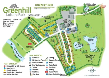
Illustrated camping and touring map with fishing lakes, dog areas and colour-coded pitches.
 Explore the map ↗
United Kingdom
Woodland park map with mixed pitches, bell tents, lodges and a fishing lake.
 Explore the map ↗
United Kingdom
A woodland estate park map combining caravan loops, touring pitches, riverside paths and Bruce’s Cave landmarks.
Features may come from the sample artwork, its key or published park information. Approximate numbers describe the drawing and may cover only part of a park. They are intended to help you compare map examples. Current facilities and booking information should be checked with the park.
LET’S MAP YOUR PARK
For a map quotation, find your park and draw a rough boundary around it. The area you select helps us work out the design time and price.
Draw your park for a quote ↗Or talk to our map designers
01751 473136