
Beach and sea
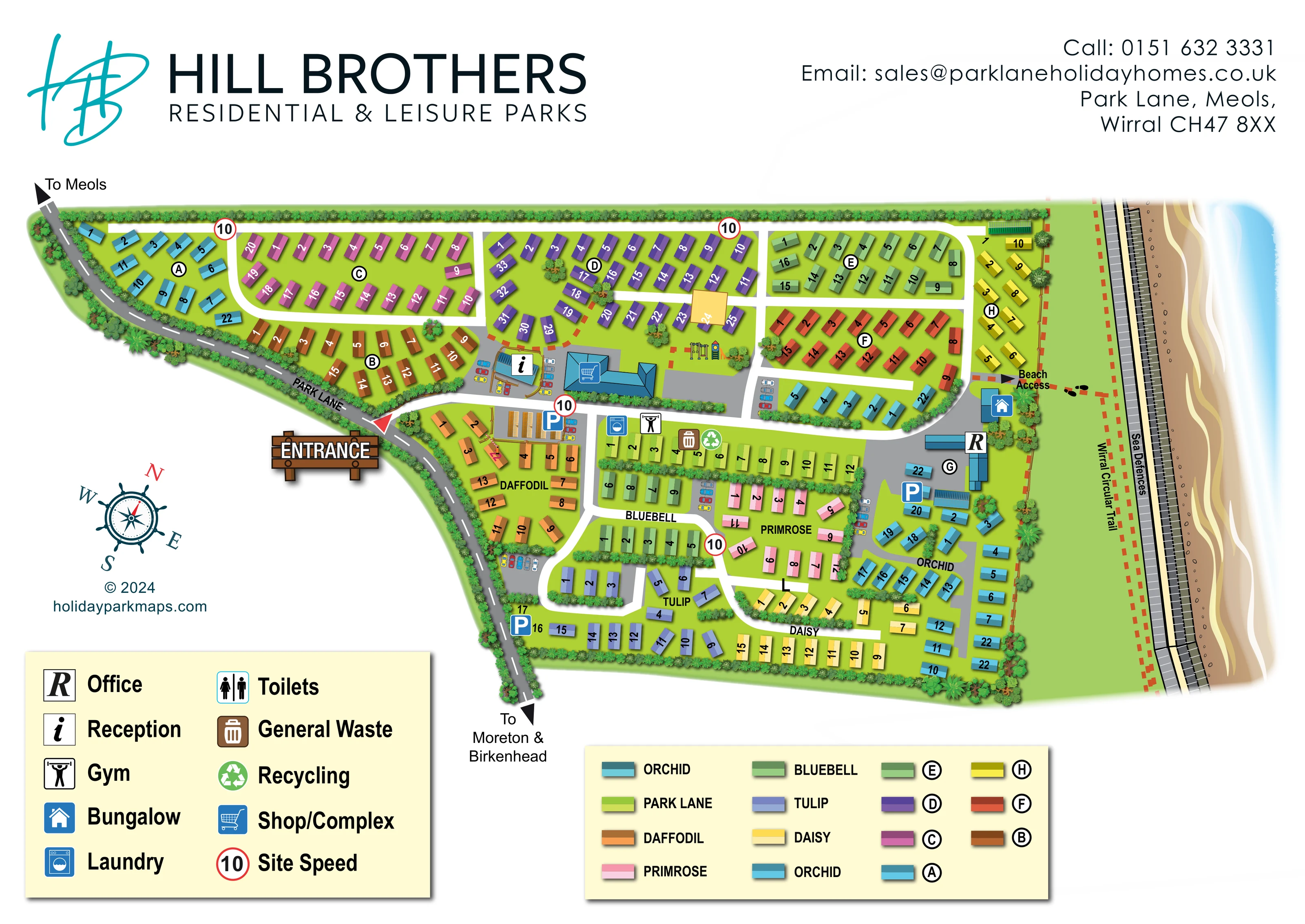
A sandy beach with layered shoreline shapes and pale blue water forms the right-hand edge of the illustration.
ILLUSTRATED PARK MAP · P242
Park Lane, Meols, Wirral · United Kingdom
 Enlarge the map ↗
A SENSE OF THE PLACE
Park Lane Holiday Park is based at Park Lane, Meols, Wirral. This is a coastal holiday-home park on the northern Wirral, close to seafront access. The park markets static caravans and lodge-style holiday homes for ownership.
The park provides a bar/club, café, gym, laundry and children's play areas. The operator describes Park Lane as pet-friendly.
LOOK CLOSER
A sandy beach with layered shoreline shapes and pale blue water forms the right-hand edge of the illustration.
A labelled, strongly delineated coastal barrier separates the green trail corridor from the beach.
Dense illustrated trees and shrubs edge the park, follow Park Lane and divide many accommodation rows.
An information symbol marks the small blue-roofed reception building beside the entrance-side parking and main complex.
The office symbol marks a blue building on the eastern side, beside sector G and the coastal boundary.
A shopping-trolley symbol identifies the larger, angular blue-roofed complex near reception.
A gym pictogram is placed along the central route, opposite the entrance-side facilities.
A washing-machine pictogram marks the laundry near the gym and the Park Lane accommodation row.
An information symbol marks the small blue-roofed reception building beside the entrance-side parking and main complex.
The office symbol marks a blue building on the eastern side, beside sector G and the coastal boundary.
A shopping-trolley symbol identifies the larger, angular blue-roofed complex near reception.
A gym pictogram is placed along the central route, opposite the entrance-side facilities.
A washing-machine pictogram marks the laundry near the gym and the Park Lane accommodation row.
Illustrated swings and a slide occupy a green space immediately east of the main complex.
A house pictogram identifies a bungalow near the beach-access route and office. Its use as visitor accommodation is not specified.
Adjacent waste-bin and recycling symbols mark a shared service point along the central route.
Blue P symbols identify parking near the entrance facilities, the eastern office area and the lower western accommodation. Small illustrated cars also clarify parking bays.
Toilets appear in the facility key, but a corresponding location is not clearly identifiable on the plan.
A large illustrated entrance sign and a red triangular marker highlight the junction from the curving external road into the park.
Arrowheads at either end of Park Lane indicate Meols in one direction and Moreton and Birkenhead in the other.
A labelled arrow and orange dashed pedestrian route lead out from the eastern side towards the coastal corridor.
The named trail runs along the green strip between the holiday-home park and the sea defences, drawn as an orange dashed route.
A sandy beach with layered shoreline shapes and pale blue water forms the right-hand edge of the illustration.
A labelled, strongly delineated coastal barrier separates the green trail corridor from the beach.
Dense illustrated trees and shrubs edge the park, follow Park Lane and divide many accommodation rows.
Red-ringed 10 symbols are repeated at internal junctions and explained as Site Speed in the key.
The catalogue context lists a bar/club and café. The artwork labels a Shop/Complex but does not separately identify these uses.
READING THE MAP
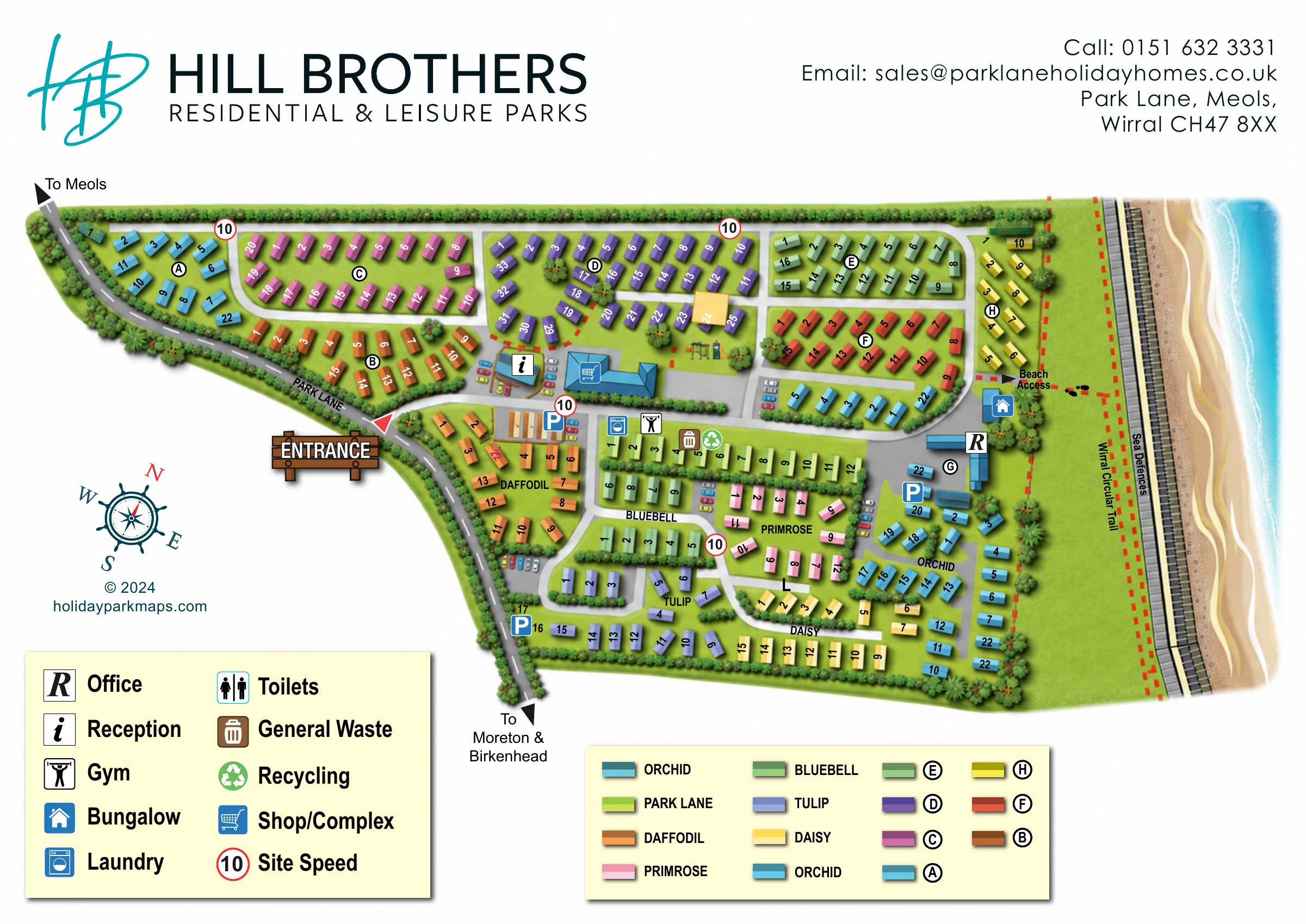
This illustrated map of Park Lane Holiday Park in Meols places a substantial holiday-home layout beside the northern Wirral coast. The plan brings together numbered homes, shared facilities and the route towards the beach, while the sea defences and Wirral Circular Trail give the site a clear relationship to its surroundings.
The accommodation is organised through a particularly useful combination of colour, letters and names. Lettered sectors occupy much of the upper half, while neighbourhoods such as Bluebell, Primrose, Tulip and Daisy shape the lower part of the plan. Distinctive colours make these groups easy to recognise without relying on plot numbers alone.
Arrival is emphasised with a timber-style entrance sign beside Park Lane, leading towards reception, parking and the main shop/complex. Illustrated planting, blue-roofed buildings and a small playground add recognisable landmarks. A sandy shoreline and nautical compass establish the coastal character, while the separate facility and colour keys keep the practical information organised beneath the main artwork.
The map presents the park as an irregular wedge between Park Lane and the coast. The external road curves around the western boundary, with arrows towards Meols and towards Moreton and Birkenhead. A prominent entrance marker leads into the central facilities area, where reception, the blue-roofed shop/complex and parking are grouped together. Swings and a slide are illustrated on the adjoining green space.
Across the northern portion, coloured holiday-home blocks sit in lettered sectors, using straight rows and angled arrangements around white internal lanes. The southern portion switches to named neighbourhoods: Park Lane, Daffodil, Bluebell, Primrose, Tulip, Daisy and Orchid. Each home carries a plot number, while contrasting colours, planted dividers and direct labels help distinguish adjoining groups. Branching lanes and loops connect these areas to the central route, with grey hardstanding and small car illustrations indicating parking spaces.
Laundry, gym, general waste and recycling symbols sit along the central route. An office and bungalow are marked towards the eastern boundary. The facility key also includes toilets, although their position is not clearly shown in the plan. Red-ringed site-speed symbols punctuate several junctions.
At the right-hand edge, a labelled beach-access route meets the Wirral Circular Trail corridor. Sea defences form a strong linear boundary before the illustrated sand and pale blue water. Orange dashed pedestrian routes contrast with the vehicle lanes.
The single landscape-format artwork is framed by Hill Brothers branding and contact information above, with two cream legend panels below. A nautical compass occupies the spare white space beside the entrance. The enlarged detail views show portions of this same composition rather than separate map variants.
 Enlarge this map ↗
KEEP EXPLORING
Chosen for shared landscapes, accommodation or facilities.
 Explore the map ↗
United Kingdom
Illustrated coastal holiday-home plan with dense alphanumeric plot labels, orange-roofed amenities, a numbered facility key and beach-side context.
 Explore the map ↗
United Kingdom
A colour-zoned coastal park map with touring areas, woodland trails, ponds and a leisure club.
 Explore the map ↗
United Kingdom
Colour-coded accommodation, central leisure facilities and coastal paths on an illustrated headland park map.
Features may come from the sample artwork, its key or published park information. Approximate numbers describe the drawing and may cover only part of a park. They are intended to help you compare map examples. Current facilities and booking information should be checked with the park.
LET’S MAP YOUR PARK
For a map quotation, find your park and draw a rough boundary around it. The area you select helps us work out the design time and price.
Draw your park for a quote ↗Or talk to our map designers
01751 473136