
Illustrated water features
A small rounded blue water feature sits above Summerleaze, with a longer narrow, winding feature inside its loop road.
ILLUSTRATED PARK MAP · P569
Bude, Cornwall · United Kingdom
 Enlarge the map ↗
A SENSE OF THE PLACE
Pentire Holiday Park is based at Bude, Cornwall. The park is near Bude on Cornwall's north coast, with access to coast and countryside. Caravan holidays are offered; the operator also markets glamping pods at Pentire.
Walking trails and an owners' lounge with venue Wi-Fi are listed. Dedicated dog-walking area and dog-wash station are listed.
LOOK CLOSER
A small rounded blue water feature sits above Summerleaze, with a longer narrow, winding feature inside its loop road.
Dense stylised trees frame the site, form a broad eastern belt and divide accommodation rows and open recreation spaces.
Information symbol placed on an orange-roofed building just inside the entrance, beside the arrival parking.
Parking symbols and marked bays appear beside reception and along the lower accommodation section; further marked bays flank the entrance approach.
An orange-roofed building and grey service yard immediately above reception carry the maintenance symbol.
A labelled display area beside the entrance loop contains a small group of yellow and orange unit illustrations, separate from the numbered accommodation.
A substantial, tree-enclosed green field occupies the north-west side, with a dog-friendly symbol and decorative paw prints.
A dog waste/bags symbol is positioned within the dog field.
Information symbol placed on an orange-roofed building just inside the entrance, beside the arrival parking.
Parking symbols and marked bays appear beside reception and along the lower accommodation section; further marked bays flank the entrance approach.
An orange-roofed building and grey service yard immediately above reception carry the maintenance symbol.
A labelled display area beside the entrance loop contains a small group of yellow and orange unit illustrations, separate from the numbered accommodation.
A substantial, tree-enclosed green field occupies the north-west side, with a dog-friendly symbol and decorative paw prints.
A dog waste/bags symbol is positioned within the dog field.
A dog-wash symbol appears beside the buildings opposite reception, close to the central access route.
An open green area above reception is labelled Picnic Area and marked with a picnic-table illustration and the legend's family-area symbol.
A defined rectangular play area lies beside the cross-park route below Duckpool and the dog field.
Repeated grey waste and recycling symbols are distributed near Duckpool, the dog-field approach and the main accommodation section.
Several red fire-extinguisher markers are shown through the Duckpool accommodation section.
Laundry is included in the facility key, but no corresponding location is clearly identifiable on the plan.
A small rounded blue water feature sits above Summerleaze, with a longer narrow, winding feature inside its loop road.
Dense stylised trees frame the site, form a broad eastern belt and divide accommodation rows and open recreation spaces.
The entrance is highlighted along the bottom road, with directional arrows towards Stibb on the left and Kilkhampton on the right.
Black footprint symbols trace a green route along the upper boundary and down the planted division between the northern sections. A northern connection is labelled towards Penstowe and Kilkhampton.
Turquoise circular markers displaying 10 appear on the internal roads. Their meaning and units are not explained in the key.
Wider park information lists an owners' lounge with venue Wi-Fi; it is not labelled on this artwork.
READING THE MAP
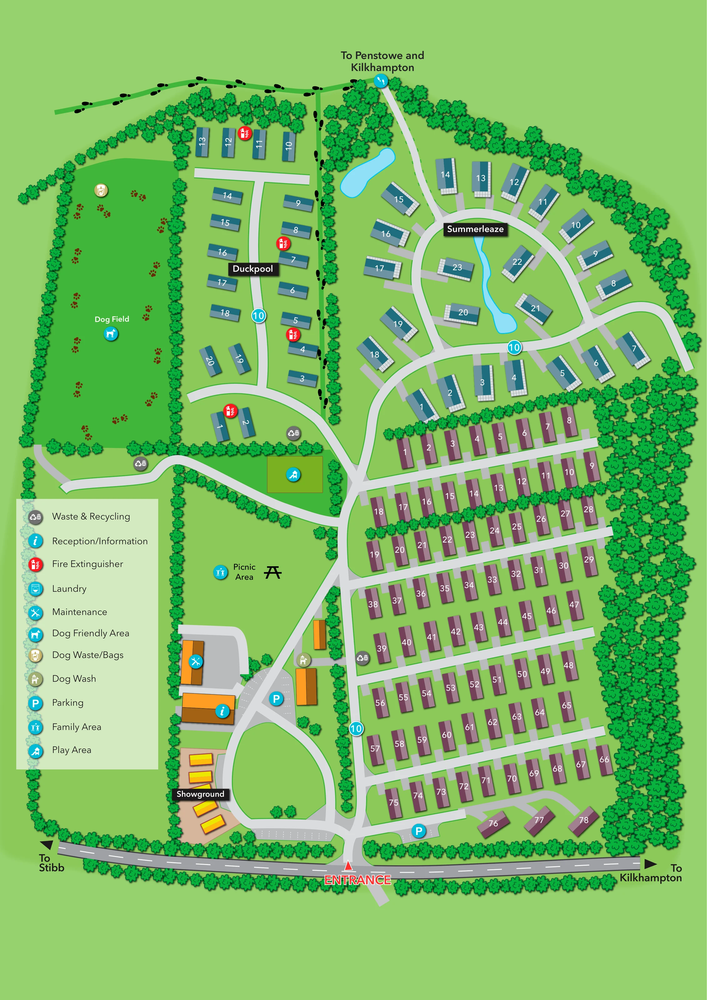
This illustrated map of Pentire Holiday Park near Bude, Cornwall, brings a tree-framed holiday park into a clear, colourful portrait plan. Its layout balances a substantial area of regularly arranged caravan-style accommodation with two smaller named sections, Duckpool and Summerleaze, and generous green spaces on the opposite side of the site. The result is a map that explains both where visitors are staying and how the park fits together.
The entrance is picked out in red along the lower road, with reception, parking and a bright yellow showground grouped nearby. Further into the park, the map shows a picnic and family area, a separate play area and a particularly prominent dog field decorated with paw prints. Summerleaze has its own visual character, with curved roads, illustrated decking and blue water features among the units. A large facility key, numbered accommodation and directional labels towards Stibb, Kilkhampton and Penstowe support practical orientation without losing the informal, outdoor character of the illustration.
The plan is organised around an entrance at the bottom edge, where the local road is labelled towards Stibb and Kilkhampton. Just inside, an arrival loop links the showground, reception, marked parking and maintenance yard. Orange service-building roofs stand apart from the accommodation, while yellow display units on a tan background give the showground an immediately recognisable identity.
A central route leads upwards and branches into three accommodation areas. The largest occupies the right-hand side in repeated rows of mauve units, connected by pale-grey lanes and short access spurs. Trees divide parts of this grid and form a dense belt along its outer edge. At the upper left, Duckpool contains smaller teal units arranged around a short access road beside the dog field. At the upper right, Summerleaze uses curved roads and more varied unit orientations, with white gridded decking and two blue water shapes helping distinguish it from the rest of the park.
The left side gives substantial space to outdoor activities. A labelled picnic area carries a table illustration and family-area badge, while the play area is marked within a separate rectangle beside the cross-site route. The large dog field is enclosed visually by trees and identified through a dog symbol, paw prints and a dog waste/bags point. A dog wash is marked near the arrival buildings.
The lower-left key explains the circular facility badges, including reception, maintenance, parking, waste and recycling, fire extinguishers and dog facilities. Laundry appears in the key without a clearly identifiable mapped position. Footprints mark walking connections around the upper boundary. The artwork is a single complete plan; the enlarged views simply reveal its finer labels and symbols.
KEEP EXPLORING
Chosen for shared landscapes, accommodation or facilities.
 Explore the map ↗
United Kingdom
Woodland-framed Barnsoul map with mixed accommodation, shared facilities and paw-marked walking routes.
 Explore the map ↗
United Kingdom
Coastal park plan with colour-coded pitches, named neighbourhoods and a Morecambe Bay walking route.
 Explore the map ↗
United Kingdom
Riverside park map with named pitch fields, illustrated huts and a paw-print dog walk.
Features may come from the sample artwork, its key or published park information. Approximate numbers describe the drawing and may cover only part of a park. They are intended to help you compare map examples. Current facilities and booking information should be checked with the park.
LET’S MAP YOUR PARK
For a map quotation, find your park and draw a rough boundary around it. The area you select helps us work out the design time and price.
Draw your park for a quote ↗Or talk to our map designers
01751 473136