
Fishing lake
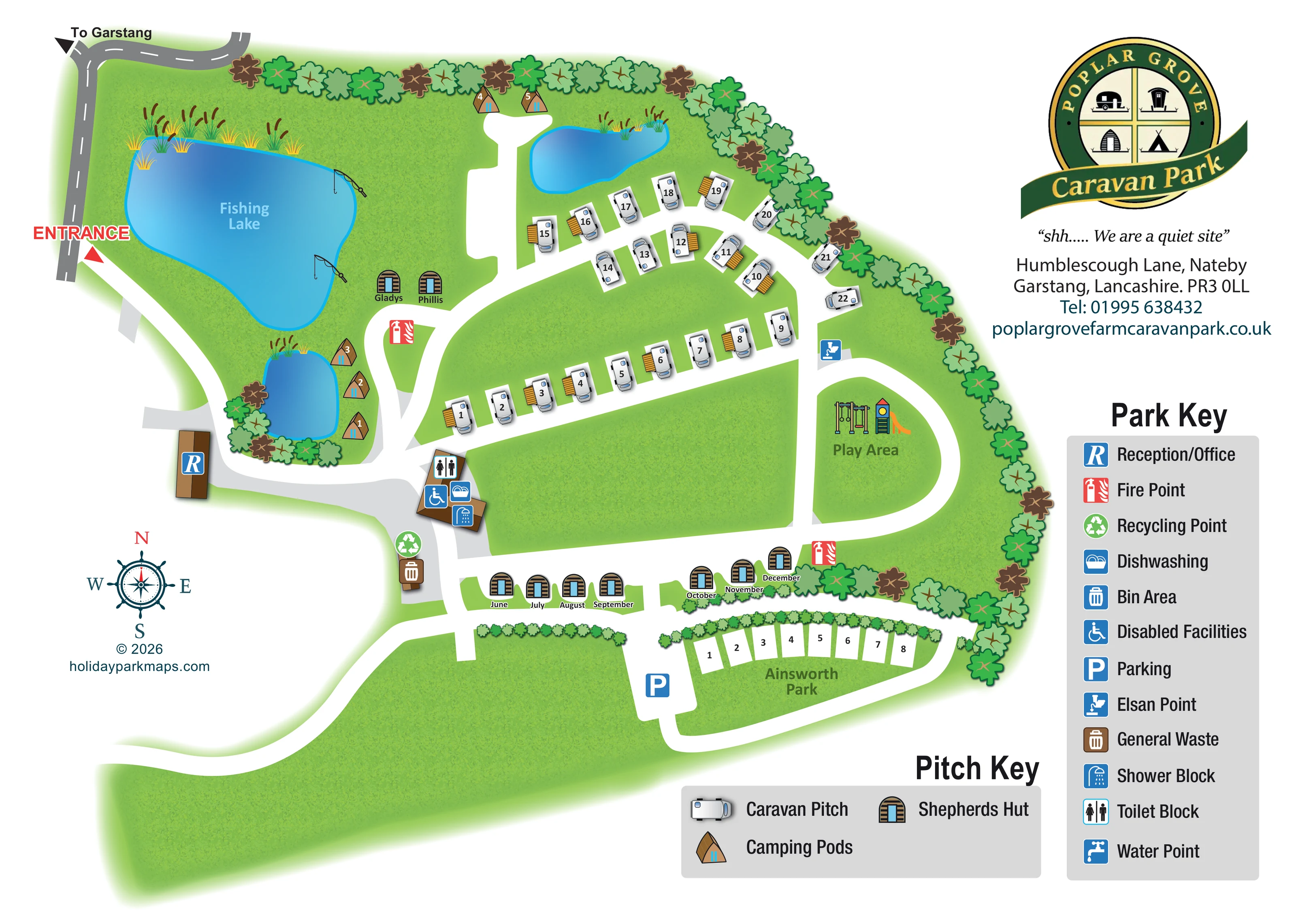
The large western lake is explicitly labelled Fishing Lake, with fishing-rod illustrations and reed-fringed banks.
ILLUSTRATED PARK MAP · P261
Humblescough Lane, Nateby, Garstang, Lancashire · United Kingdom
 Enlarge the map ↗
A SENSE OF THE PLACE
Poplar Grove Farm Caravan Park is located on a working family farm at Nateby near Garstang. Hardstanding touring pitches with electricity sit alongside pods and shepherd's huts.
The rural location offers views towards the Bowland fells and opportunities for walking and cycling. Its map helps visitors locate the different accommodation areas and understand the site's arrangement within the farm setting.
LOOK CLOSER
The large western lake is explicitly labelled Fishing Lake, with fishing-rod illustrations and reed-fringed banks.
Two smaller blue water bodies lie near the camping pod groups, one below the fishing lake and one along the northern edge. They are not separately labelled as fishing waters.
A continuous illustrated tree belt follows the northern and eastern boundary, with smaller trees around the lower pond and low hedges separating the lower accommodation areas.
A small brown building marked with the reception symbol sits beside the entrance approach on the left.
A labelled play area with swings and a slide occupies a grassy island inside the eastern route loop.
Toilet, shower and dishwashing symbols are grouped over a brown building near the central entrance-side junction.
The key's disabled-facilities symbol is placed at the central washroom building; the map does not describe the facilities in further detail.
An Elsan-point symbol appears beside the eastern caravan route, just above the play-area loop.
A small brown building marked with the reception symbol sits beside the entrance approach on the left.
The large western lake is explicitly labelled Fishing Lake, with fishing-rod illustrations and reed-fringed banks.
Two smaller blue water bodies lie near the camping pod groups, one below the fishing lake and one along the northern edge. They are not separately labelled as fishing waters.
A labelled play area with swings and a slide occupies a grassy island inside the eastern route loop.
Toilet, shower and dishwashing symbols are grouped over a brown building near the central entrance-side junction.
The key's disabled-facilities symbol is placed at the central washroom building; the map does not describe the facilities in further detail.
An Elsan-point symbol appears beside the eastern caravan route, just above the play-area loop.
General-waste and recycling symbols are grouped beside the route below the washroom building.
Red fire-point symbols mark locations near the lake-side route junction and the lower hut row.
A blue parking symbol marks the broad access area beside Ainsworth Park.
A water-point symbol is included in the Park Key, but no corresponding position is clearly identifiable on the plan.
The key includes a blue Bin Area symbol, separate from the general-waste and recycling symbols visibly placed on the map.
A red ENTRANCE label and triangle identify the western arrival point from the grey road. A black arrow on that road points towards Garstang.
Broad white routes connect reception, the caravan rows, waterside glamping groups, play area and the lower Ainsworth Park loop.
A continuous illustrated tree belt follows the northern and eastern boundary, with smaller trees around the lower pond and low hedges separating the lower accommodation areas.
A separately named lower section contains a short numbered plot row, a hedge boundary, adjacent parking and its own curving access route.
READING THE MAP
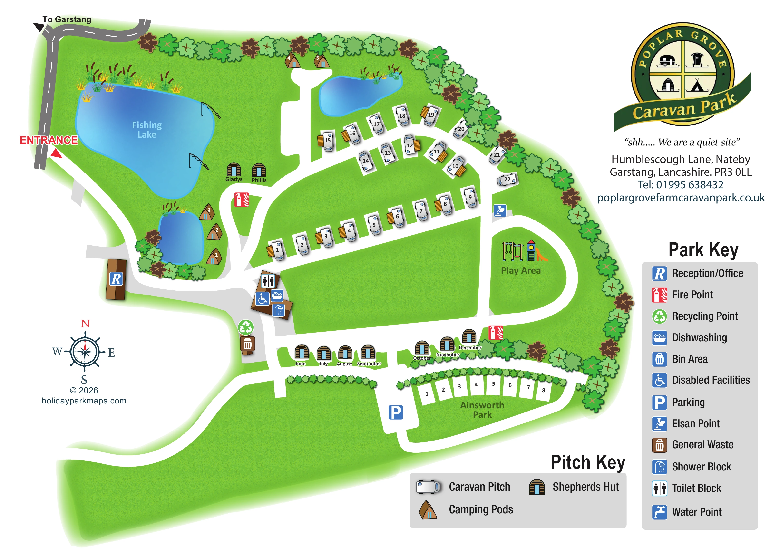
This illustrated map of Poplar Grove Farm Caravan Park brings together touring pitches, shepherd's huts and camping pods in a compact rural layout at Nateby, near Garstang in Lancashire. A large fishing lake anchors the western side of the plan, while two smaller ponds, a broad tree-lined boundary and open grass areas give the artwork its distinctive farm-park character.
The map makes the different accommodation groups easy to recognise without treating every stay in the same way. Overhead caravan illustrations follow the internal lanes, pointed camping pods sit beside the ponds, and timber-fronted shepherd's huts carry individual names. The separately labelled Ainsworth Park area adds another clearly defined section at the bottom of the plan.
Practical visitor information is integrated into this landscape: reception sits near the entrance, the washroom building is marked with several service symbols, and parking, waste facilities, fire points and the play area are clearly identified. Separate Park and Pitch keys support the illustration, while the green-and-gold logo and generous white page margins keep the park's branding distinct from the route information.
The single-page plan is organised around a western entrance from a grey road carrying a direction arrow to Garstang. A broad white approach passes the reception building and curves towards a central junction beside the washroom block. From here, branching lanes connect the main caravan rows, the waterside accommodation and the lower section of the site.
Touring pitches occupy the centre and north-east, with numbered caravan symbols placed on white pads along straight and curved lanes. Their arrangement leaves a substantial open grass area in the middle. On the eastern side, a loop encloses the labelled play area, illustrated with swings and a slide. An Elsan point is marked nearby.
The western fishing lake is the strongest landscape feature, drawn with blue shading, a turquoise shoreline, reeds and fishing rods. Gladys and Phillis, two named shepherd's huts, stand beside its southern shore. Camping pods appear beside the smaller lower pond and near the northern pond. Along the bottom lane, another group of huts uses month names, helping visitors recognise this accommodation row independently of the numbered caravan pitches.
Below these huts, hedging separates the labelled Ainsworth Park plots from the rest of the plan. An adjacent parking symbol and curving access lane clarify how this lower area connects to the wider site. Toilets, showers, dishwashing and disabled-facilities symbols share the central service building; recycling and general waste are grouped just below it, and red fire-point symbols stand out elsewhere along the routes.
The right-hand column combines park branding and contact information with a tall facility legend. A separate accommodation key sits beneath the plan, and a compass rose occupies the lower-left margin.
KEEP EXPLORING
Chosen for shared landscapes, accommodation or facilities.
 Explore the map ↗
United Kingdom
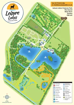
Illustrated Leisure Lakes map combining a loop-road touring area, golf course, driving range and lakeside recreation in a green-and-blue portrait layout.
 Explore the map ↗
United Kingdom
Woodland park map with mixed pitches, bell tents, lodges and a fishing lake.
 Explore the map ↗
United Kingdom
Illustrated caravan park plan with woodland and riverside walks, fishing pools and wildlife panels.
Features may come from the sample artwork, its key or published park information. Approximate numbers describe the drawing and may cover only part of a park. They are intended to help you compare map examples. Current facilities and booking information should be checked with the park.
TAKE A CLOSER LOOK
View the illustrated map in detail or choose a file to download. These are sample maps; contact the park for current visitor information.


LET’S MAP YOUR PARK
For a map quotation, find your park and draw a rough boundary around it. The area you select helps us work out the design time and price.
Draw your park for a quote ↗Or talk to our map designers
01751 473136
 poplargrovemap_large.png