
Tree-lined boundaries and planted divisions
Layered tree and shrub illustrations line the roads, frame the camping field and separate a northern enclosure from the pod area.
ILLUSTRATED PARK MAP · P262
Hulland Ward, Ashbourne, Derbyshire · United Kingdom
 Enlarge the map ↗
A SENSE OF THE PLACE
Poplars Farm Campsite is based at Hulland Ward, Ashbourne, Derbyshire. The park offers tent/touring stays, glamping pods and a holiday cottage.
Hook-up electricity is metered rather than charged at a fixed daily rate. The park lists Wi-Fi, washing-up facilities, toilets and a heated shower area. The park welcomes suitable dogs and provides a meadow walk; two dog-friendly pods gained enclosed outdoor areas for 2026.
LOOK CLOSER
Layered tree and shrub illustrations line the roads, frame the camping field and separate a northern enclosure from the pod area.
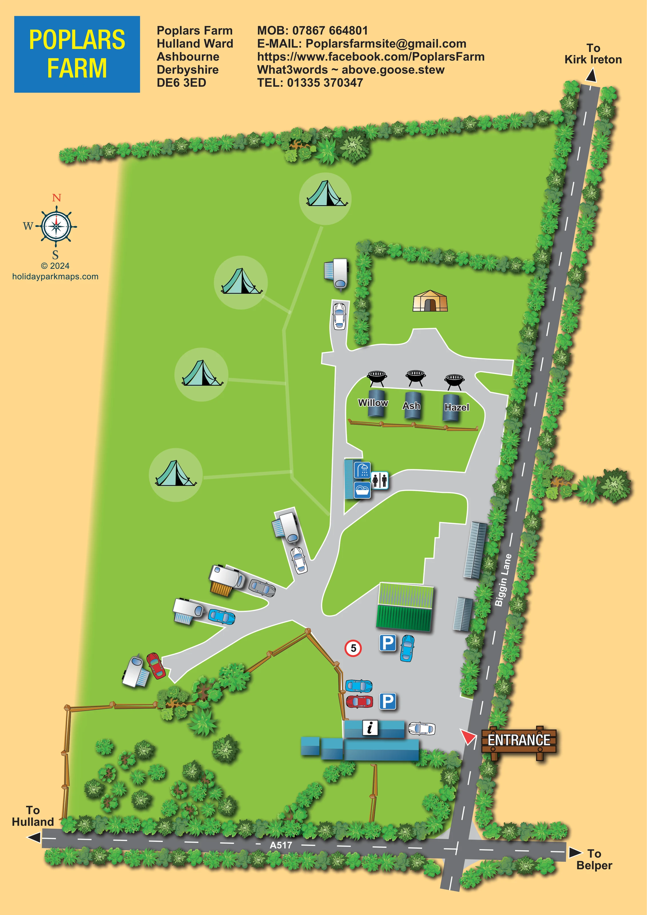
Timber fencing and scattered trees define a green area west and south of the entrance buildings. No specific visitor use is labelled.
A large timber-style ENTRANCE sign and red triangular pointer mark access from Biggin Lane beside the southern building group.
Biggin Lane follows the eastern boundary and meets the A517 along the bottom of the plan. Directional arrows point towards Kirk Ireton, Hulland and Belper.
A broad grey internal drive runs from the arrival yard into short touring branches and a loop around the named pod area.
A pale branching line connects the tent illustrations with the internal drive; its precise route function is not labelled.
An information symbol is placed on the blue-roofed building group immediately inside the entrance.
Two blue P symbols and illustrated cars identify parking within the paved arrival yard.
A large timber-style ENTRANCE sign and red triangular pointer mark access from Biggin Lane beside the southern building group.
Biggin Lane follows the eastern boundary and meets the A517 along the bottom of the plan. Directional arrows point towards Kirk Ireton, Hulland and Belper.
A broad grey internal drive runs from the arrival yard into short touring branches and a loop around the named pod area.
A pale branching line connects the tent illustrations with the internal drive; its precise route function is not labelled.
An information symbol is placed on the blue-roofed building group immediately inside the entrance.
Two blue P symbols and illustrated cars identify parking within the paved arrival yard.
Toilet, shower and dishwashing pictograms are grouped beside a narrow blue-roofed building just south-west of the pod row.
Three black kettle-barbecue illustrations sit beside Willow, Ash and Hazel.
A red-bordered circular sign containing 5 is drawn in the arrival yard.
Layered tree and shrub illustrations line the roads, frame the camping field and separate a northern enclosure from the pod area.
Timber fencing and scattered trees define a green area west and south of the entrance buildings. No specific visitor use is labelled.
Several roofed structures occupy the arrival yard, while a tan tent-like shelter stands in the northern hedged enclosure. Their functions are not specified.
READING THE MAP
This illustrated map of Poplars Farm Campsite brings a small Derbyshire site into a single, easy-to-follow portrait plan. Set at Hulland Ward near Ashbourne, the campsite is shown beside Biggin Lane and the A517, with clear arrows towards Kirk Ireton, Hulland and Belper. The surrounding roads are part of the main illustration, helping visitors relate the entrance to the local junction before exploring the site itself.
Inside the boundary, the design distinguishes open camping grass from touring-caravan positions and a compact row of three glamping pods. Willow, Ash and Hazel are named directly on their blue-grey roofs, with barbecue illustrations beside them. Parking and an information point sit close to the entrance, while toilet, shower and washing-up symbols identify the central amenity building.
Bright green fields, layered tree borders and timber fencing establish the rural character without obscuring the routes. A blue-and-yellow title panel, warm ochre background and large timber-style entrance sign give this sample a particularly recognisable visual identity.
The plan is organised around a clear arrival sequence. Biggin Lane runs down the right-hand side, meeting the A517 across the bottom of the sheet. A red pointer and large wooden ENTRANCE sign mark the turn into a grey paved yard. Here, parking symbols, illustrated cars and an information icon on the blue-roofed building group provide the first visitor landmarks. A small red-bordered 5 sign is also drawn within the yard.
From this arrival space, the internal drive branches towards a handful of touring-caravan positions on the western side. Each caravan is illustrated with an awning and a nearby car, making this area visually different from the open camping field beyond. Across that field, upright tent symbols sit within pale-green circles connected by a lighter branching line. These symbols communicate the camping area without presenting a numbered pitch grid.
Further north, the drive forms a loop around Willow, Ash and Hazel. The three pods stand in a row behind a timber fence, with separate kettle-barbecue illustrations along their approach side. A narrow amenity building beside the loop carries grouped shower, washing-up and toilet pictograms. Above the pods, a hedged enclosure contains a tan tent-like shelter whose use is not labelled.
Dense illustrated hedges and tree crowns trace the roadside boundaries, while scattered planting and fencing define the southern green space. White-edged internal drives contrast with darker public roads and their dashed centre lines. The sheet uses direct labels and familiar symbols rather than a separate key, with a compass rose in the left margin and branding and contact information across the top.
KEEP EXPLORING
Chosen for shared landscapes, accommodation or facilities.
 Explore the map ↗
United Kingdom
Woodland-framed Barnsoul map with mixed accommodation, shared facilities and paw-marked walking routes.
 Explore the map ↗
United Kingdom
A stream-side farm campsite plan with car-free camping, caravan pitches and separate bell-tent areas.
 Explore the map ↗
United Kingdom
Woodland park map with mixed pitches, bell tents, lodges and a fishing lake.
Features may come from the sample artwork, its key or published park information. Approximate numbers describe the drawing and may cover only part of a park. They are intended to help you compare map examples. Current facilities and booking information should be checked with the park.
LET’S MAP YOUR PARK
For a map quotation, find your park and draw a rough boundary around it. The area you select helps us work out the design time and price.
Draw your park for a quote ↗Or talk to our map designers
01751 473136