
Beach and coastal edge
A sweeping pale-blue sea, white surf strokes, sandy shore and small outlined stones frame the top of the artwork.
ILLUSTRATED PARK MAP · P267
Quarryfield Caravan Park, Vosporth Hill, Crantock, Newquay · United Kingdom
 Enlarge the map ↗
A SENSE OF THE PLACE
Quarryfield is a family-run holiday park at Crantock near Newquay. Its location on the West Pentire headland places it close to Crantock Beach and the surrounding Cornish coast.
Caravans, chalets, touring and camping provide a range of stays. Toilets, showers and laundry support visitors, with the map helping guests locate the different accommodation areas and shared facilities.
LOOK CLOSER
A sweeping pale-blue sea, white surf strokes, sandy shore and small outlined stones frame the top of the artwork.
Large green fields above the accommodation are separated by repeated shrub symbols and bordered by denser mixed foliage.
A reception symbol marks a blue-roofed building beside the central road junction.
A wine-glass symbol identifies the bar in the blue-roofed building cluster near reception.
A light-blue rectangular pool with a swimming pictogram sits beside the central facilities and caravan areas.
A colourful slide tower and swing frame are illustrated on a small green space at the edge of the touring rows.
Toilet symbols appear at the central buildings and beside the lower caravan group; a shower symbol is included in the central service cluster.
A wheelchair symbol marks the toilet facility in the central service cluster; the key labels this 'Disabled Toilet'.
A reception symbol marks a blue-roofed building beside the central road junction.
A wine-glass symbol identifies the bar in the blue-roofed building cluster near reception.
A light-blue rectangular pool with a swimming pictogram sits beside the central facilities and caravan areas.
A colourful slide tower and swing frame are illustrated on a small green space at the edge of the touring rows.
Toilet symbols appear at the central buildings and beside the lower caravan group; a shower symbol is included in the central service cluster.
A wheelchair symbol marks the toilet facility in the central service cluster; the key labels this 'Disabled Toilet'.
A washing-machine symbol is positioned with the shared facilities beside the lower caravan group.
A dish-washing symbol appears in the central row of service icons.
The chemical-disposal pictogram is shown beside the other touring support facilities.
A blue tap symbol marks a water point within the smaller upper touring-pitch strip.
Bin symbols are distributed through the lower touring area, central facilities and upper caravan corridor.
A dog-waste symbol is shown beside the play area and central touring routes.
A red charging symbol beside the lower caravan group is annotated 'x3'.
A green AED symbol is placed at the central blue-roofed building cluster.
Red fire-point symbols occur in both the lower touring area and the upper accommodation corridor.
A green assembly symbol marks the central junction near the pool and shared buildings.
Parking is defined in the key, but a corresponding position is not clearly identifiable on the plan.
Brown dashes and black footprints trace a route from the upper accommodation corridor across hedge-divided fields to the illustrated beach.
A sweeping pale-blue sea, white surf strokes, sandy shore and small outlined stones frame the top of the artwork.
Large green fields above the accommodation are separated by repeated shrub symbols and bordered by denser mixed foliage.
A prominent red entrance arrow sits at the Vosporth Hill and Trevelveth Road junction, with an outward arrow labelled 'To Crantock'.
An unnumbered grass strip within the lower road network is explicitly labelled 'NON HOOK-UPS'.
READING THE MAP
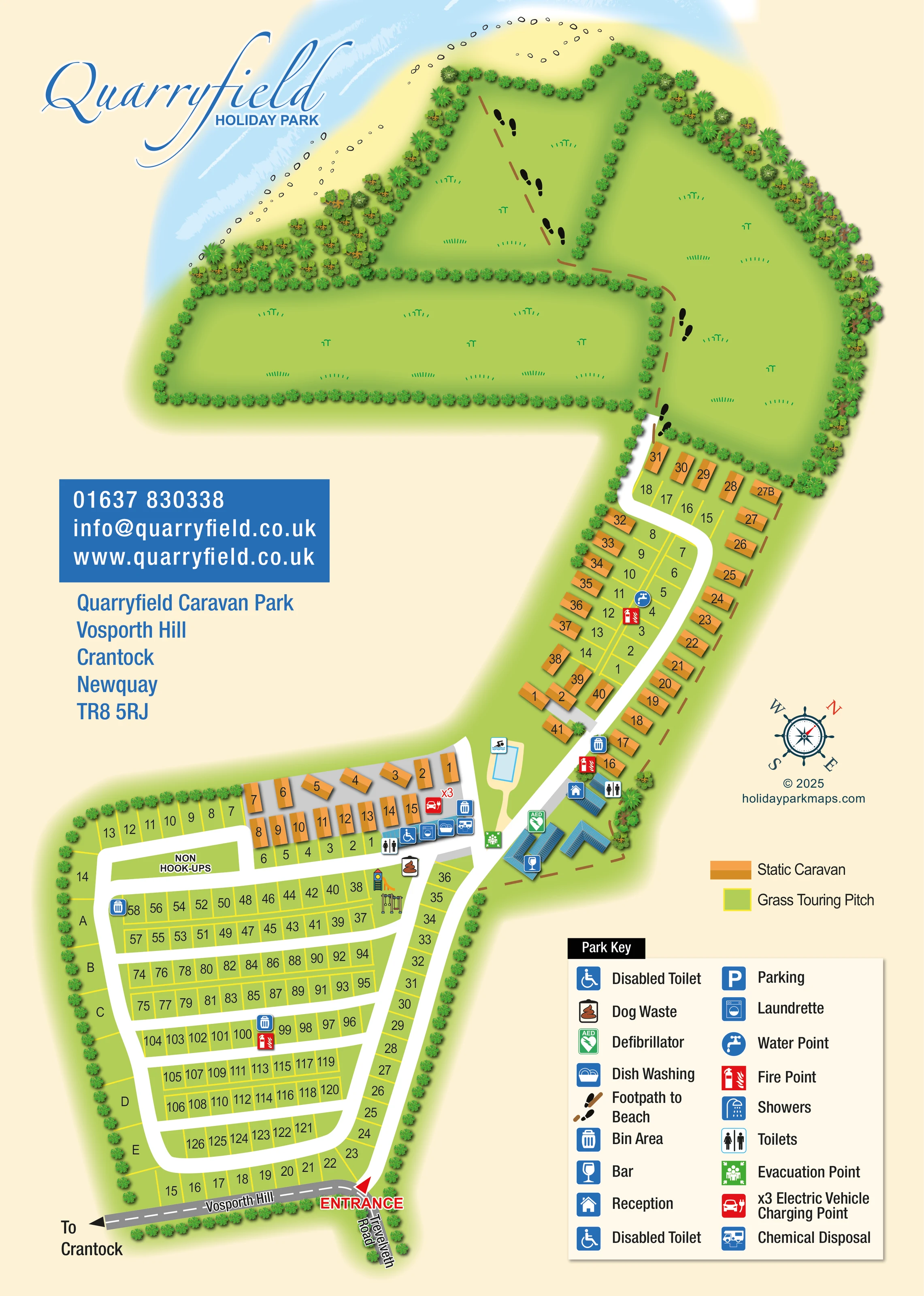
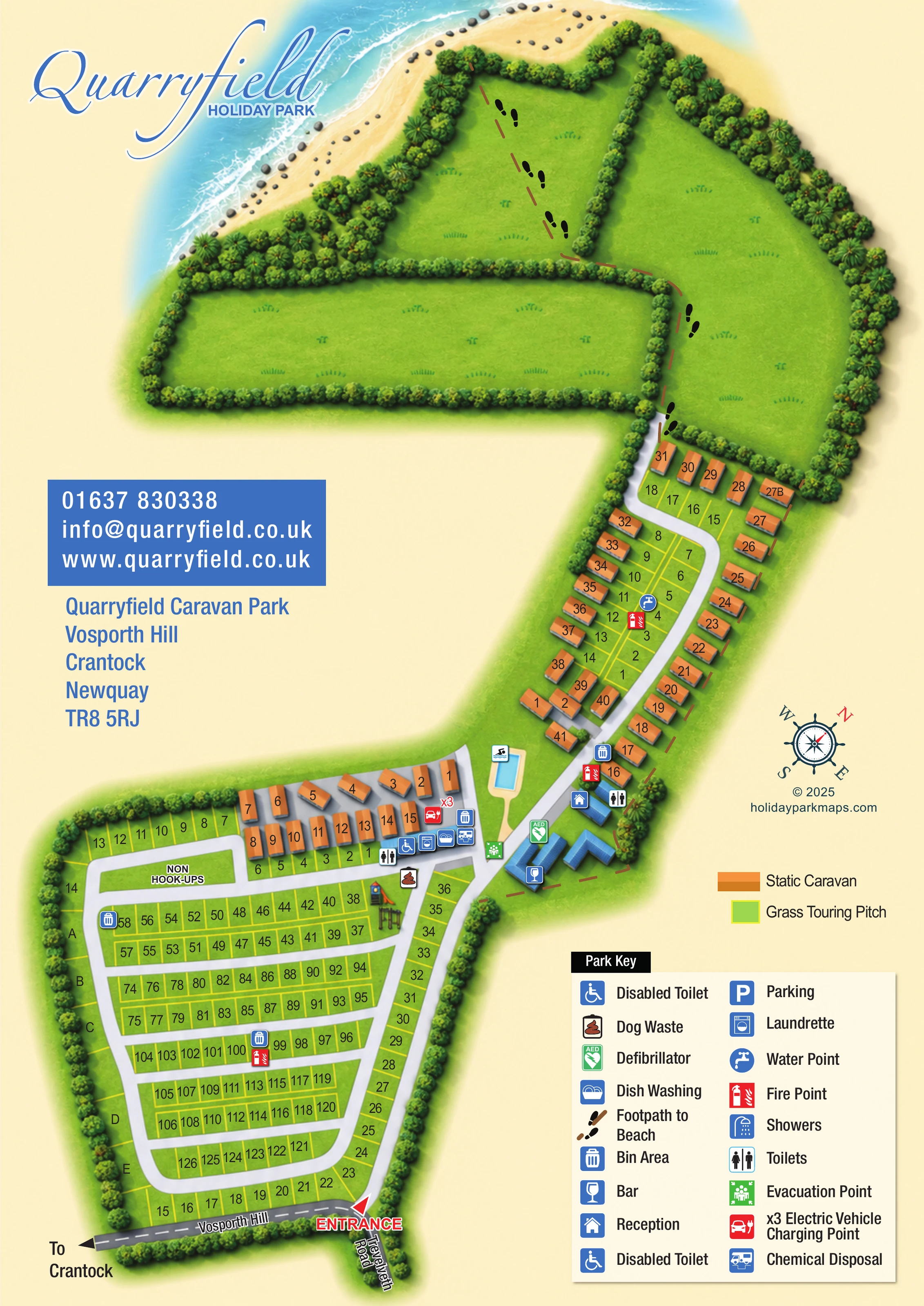
This illustrated map of Quarryfield Holiday Park brings together a busy touring layout and a distinctly coastal setting at Crantock, near Newquay. The portrait artwork follows the park from its road entrance at the bottom of the page, through numbered accommodation areas and shared facilities, to open fields and an illustrated beach at the top. A dashed route with footprint symbols makes the walk towards the shore an especially memorable part of the design.
Orange static caravans contrast with yellow-outlined grass touring pitches, helping visitors distinguish the two main accommodation types immediately. White roads organise the lower touring field into accessible-looking rows on the plan, while a winding spine connects the upper caravan area. Reception, the bar, a swimming pool and a small play area provide recognisable landmarks around the central junction.
The large Park Key supports practical navigation with pictograms for washing facilities, waste disposal, water, charging and safety equipment. Blue script branding, a separate contact panel and a soft cream background give the map a clear identity without competing with its detailed visitor information.
The plan begins with a red entrance arrow beside the junction of Vosporth Hill and Trevelveth Road. A grey approach road continues towards Crantock, while white internal roads lead into the main touring area. Here, yellow-outlined pitches form parallel rows within a rounded perimeter loop, with lettered sections A–E along the left edge. An unallocated strip near the top of this area is labelled non-hook-ups.
A compact group of orange static caravans sits above the touring rows. Beside it, a line of service pictograms identifies toilets, an accessible toilet, showers, dish washing, laundry and chemical disposal. An electric vehicle charging symbol carries an x3 annotation. The nearby slide tower and swings give the play area a distinctive visual identity, while a rectangular blue pool is shown across the central road.
Reception and the bar are marked on blue-roofed buildings at the junction between the lower field and the upper accommodation corridor. This longer section follows a curving road, with caravans around its edges and a smaller set of grass touring pitches within it. Bin and fire-point symbols recur across the developed areas; a tap symbol identifies a water point in the upper touring strip. Green symbols locate the defibrillator and evacuation point near the central buildings.
Beyond the caravans, the road gives way to a brown dashed footpath with black footprints. It crosses broad hedge-divided fields towards the sandy shoreline, where pale-blue water and white surf strokes complete the coastal illustration. The lower-right key and compass balance the logo and contact panel on the left. The accompanying detail views enlarge the entrance and legend from this same portrait artwork rather than showing separate park sections.
 Enlarge this map ↗
KEEP EXPLORING
Chosen for shared landscapes, accommodation or facilities.
 Explore the map ↗
United Kingdom
Coastal park map with static-caravan rows, touring pitches, a camping field and two leisure clusters.
 Explore the map ↗
United Kingdom
A colour-zoned coastal park map with touring areas, woodland trails, ponds and a leisure club.
 Explore the map ↗
United Kingdom
Colour-coded accommodation, central leisure facilities and coastal paths on an illustrated headland park map.
Features may come from the sample artwork, its key or published park information. Approximate numbers describe the drawing and may cover only part of a park. They are intended to help you compare map examples. Current facilities and booking information should be checked with the park.
TAKE A CLOSER LOOK
View the illustrated map in detail or choose a file to download. These are sample maps; contact the park for current visitor information.


LET’S MAP YOUR PARK
For a map quotation, find your park and draw a rough boundary around it. The area you select helps us work out the design time and price.
Draw your park for a quote ↗Or talk to our map designers
01751 473136