
Tree-lined boundary
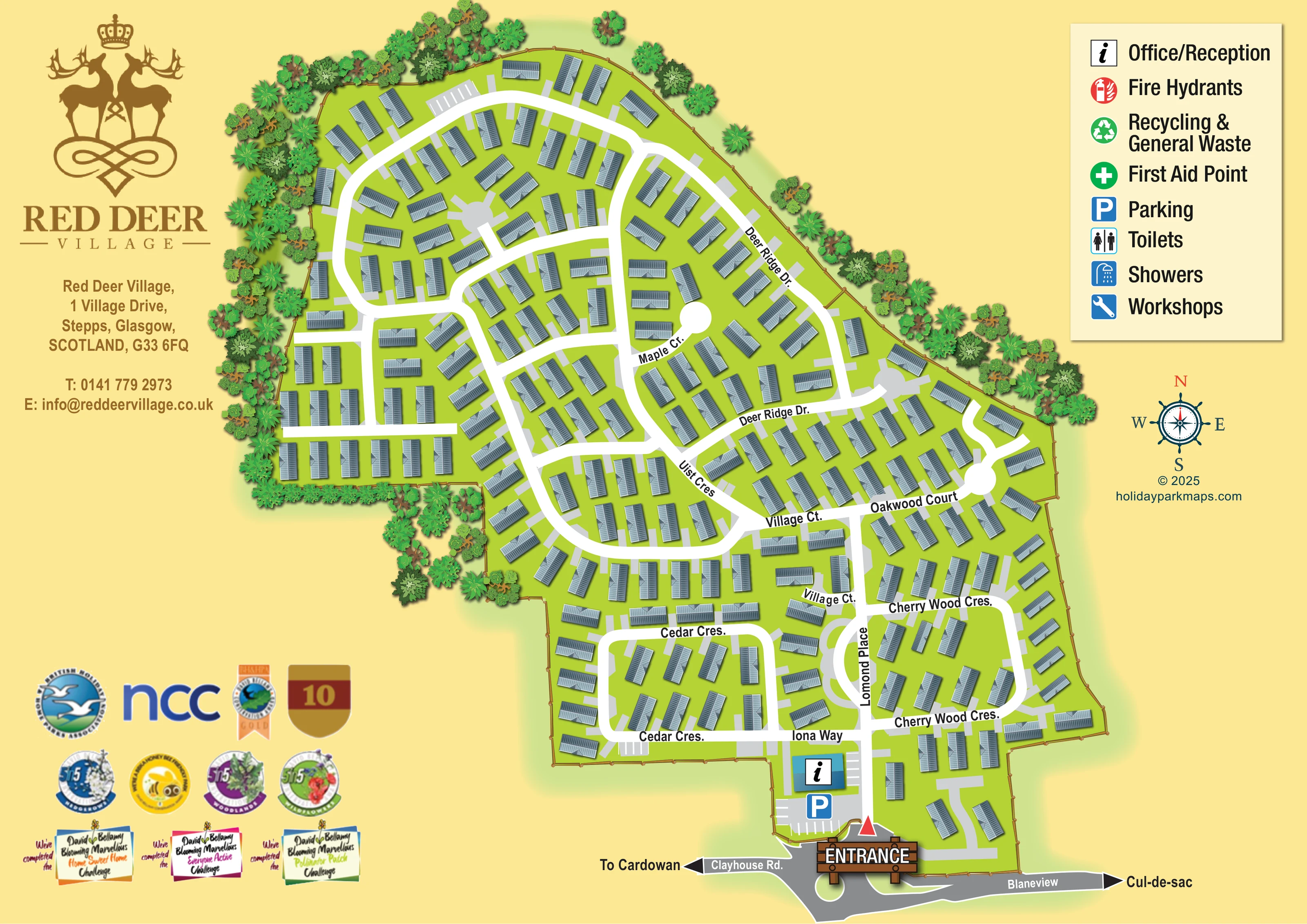
Dense illustrated trees and shrubs follow much of the northern and western perimeter, with further planting along the north-eastern edge and a recessed western boundary.
ILLUSTRATED PARK MAP · P270
Red Deer Village, 1 Village Drive, Stepps, Glasgow, SCOTLAND · United Kingdom
 Enlarge the map ↗
A SENSE OF THE PLACE
Red Deer Village Holiday Park provides camping, touring and chalet stays at Stepps near Glasgow. Hardstanding touring pitches with electricity offer a base for visitors bringing a caravan or motorhome.
The site welcomes dogs and provides washroom facilities for touring and camping guests. Its location combines access to Glasgow with excursions to surrounding towns and attractions, while the map shows the holiday park layout.
LOOK CLOSER
Dense illustrated trees and shrubs follow much of the northern and western perimeter, with further planting along the north-eastern edge and a recessed western boundary.
Bright green ground separates the units and roads, forming a continuous landscaped village setting rather than distinct camping fields.
A fine brown post-and-rail-style boundary traces the irregular village outline.
A blue building carrying the information symbol stands immediately inside the southern entrance, beside Iona Way and the arrival parking.
A marked car park with a blue P symbol adjoins reception. Smaller groups of striped parking bays also appear elsewhere in the village.
An oversized timber entrance sign and red pointer identify the access from the road along the bottom of the map.
Clayhouse Road is labelled to the left of the entrance with an arrow towards Cardowan; Blaneview extends right towards a labelled cul-de-sac.
Labels identify Lomond Place, Iona Way, Cedar Crescent, Cherry Wood Crescent, Village Court, Oakwood Court, Uist Crescent, Deer Ridge Drive and Maple Cr.
A blue building carrying the information symbol stands immediately inside the southern entrance, beside Iona Way and the arrival parking.
A marked car park with a blue P symbol adjoins reception. Smaller groups of striped parking bays also appear elsewhere in the village.
Listed with a red fire symbol in the key; corresponding locations are not apparent on the plan.
A green recycling symbol appears in the key, without a clearly placed counterpart within the village.
Included in the key as a white cross on green; no location is clearly marked.
Toilets are listed in the key, but their position is not visibly identified on this artwork.
Showers are listed with a blue symbol in the key, rather than clearly located on the plan.
The key includes a blue spanner symbol for workshops; no matching site marker is evident.
Dense illustrated trees and shrubs follow much of the northern and western perimeter, with further planting along the north-eastern edge and a recessed western boundary.
Bright green ground separates the units and roads, forming a continuous landscaped village setting rather than distinct camping fields.
A fine brown post-and-rail-style boundary traces the irregular village outline.
An oversized timber entrance sign and red pointer identify the access from the road along the bottom of the map.
Clayhouse Road is labelled to the left of the entrance with an arrow towards Cardowan; Blaneview extends right towards a labelled cul-de-sac.
Labels identify Lomond Place, Iona Way, Cedar Crescent, Cherry Wood Crescent, Village Court, Oakwood Court, Uist Crescent, Deer Ridge Drive and Maple Cr.
Interconnected curving streets include rounded turning heads, short branches and enclosed loops serving groups of homes.
READING THE MAP
This illustrated map of Red Deer Village in Stepps, near Glasgow, presents a large, street-based village within a tree-lined boundary. Rather than dividing the site into numbered pitch blocks, the artwork uses named roads, connected loops and recognisable arrival landmarks to explain how the village fits together. Repeated blue-grey roof illustrations sit on bright green plots, with pale grey driveways linking them to a broad white road network.
The entrance is particularly prominent: a timber-style sign marks the southern approach, while reception and parking sit immediately inside. From here, Lomond Place and Iona Way connect visitors to streets including Cedar Crescent, Cherry Wood Crescent and Deer Ridge Drive. Trees and shrubs soften the irregular perimeter without obscuring the internal routes.
The page also gives substantial space to identity. A crowned deer emblem, address panel and collection of environmental and industry badges balance the central plan, while a cream symbol key and compass occupy the right-hand side. It is a useful sample for clients needing a branded village map where street recognition matters more than individual plot numbering.
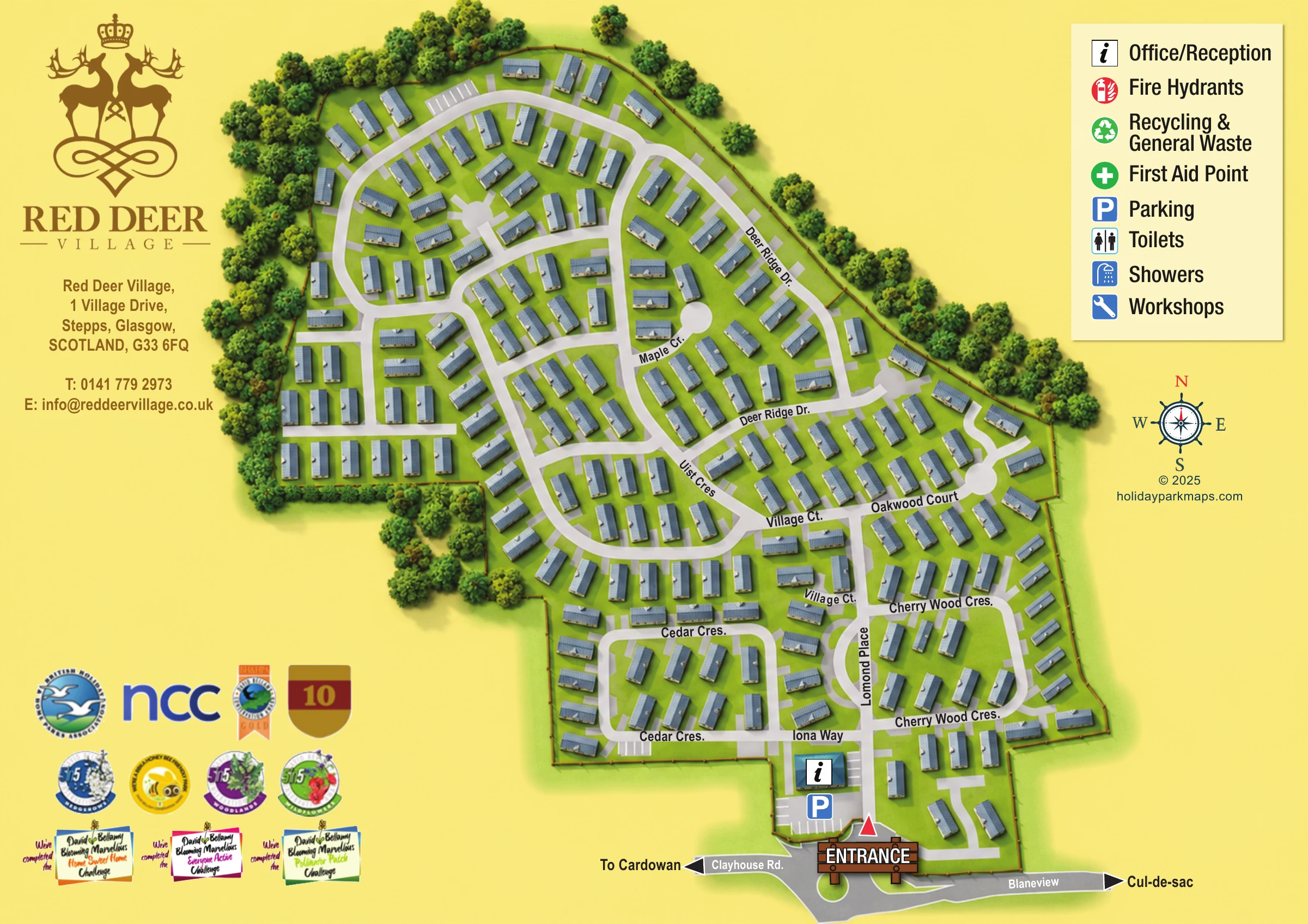
The single landscape-format artwork shows the village as an overhead plan, with shaded roofs and layered trees adding depth. Its footprint widens towards the north-west and narrows at the southern entrance. A fine brown fence follows the uneven boundary, accompanied by dense planting across much of the northern and western edges. Inside, the consistent green ground treatment keeps the numerous home symbols visually connected.
Arrival is shown from the grey road along the bottom of the page. Clayhouse Road points left towards Cardowan, while Blaneview runs right towards a labelled cul-de-sac. An oversized wooden entrance sign and red pointer identify the access. Just beyond it, a teal reception building carries an information symbol, and an adjacent striped car park is marked with a blue P.
Lomond Place provides a clear route north from the entrance, crossing Iona Way and connecting with the southern loops of Cedar Crescent and Cherry Wood Crescent. Village Court, Oakwood Court, Uist Crescent and Deer Ridge Drive structure the middle of the plan. Farther north, curving roads, short branches and circular turning heads serve additional groups of homes. The roof symbols are rotated to suit these changing alignments, and short grey connections indicate individual driveways or hardstanding.
Black street labels sit directly on the white roads, avoiding a separate index. The upper-right key lists reception, fire hydrants, recycling and general waste, first aid, parking, toilets, showers and workshops; only reception and parking are clearly positioned on the plan. A compass and designer credit sit below. The left-hand brand panel and lower-left badges complete the composition. The enlarged detail views show portions of this same artwork, rather than separate site sections.
 Enlarge this map ↗
KEEP EXPLORING
Chosen for shared landscapes, accommodation or facilities.
 Explore the map ↗
United Kingdom
Colour-coded campsite map with riverside pitches, bell tents, a swimming pool and fishing lake.
 Explore the map ↗
United Kingdom
Coastal park map with static-caravan rows, touring pitches, a camping field and two leisure clusters.
 Explore the map ↗
United Kingdom
A wooded Allerton park plan with colour-coded neighbourhoods, touring pitches and a central facilities hub.
Features may come from the sample artwork, its key or published park information. Approximate numbers describe the drawing and may cover only part of a park. They are intended to help you compare map examples. Current facilities and booking information should be checked with the park.
LET’S MAP YOUR PARK
For a map quotation, find your park and draw a rough boundary around it. The area you select helps us work out the design time and price.
Draw your park for a quote ↗Or talk to our map designers
01751 473136