
Central lake
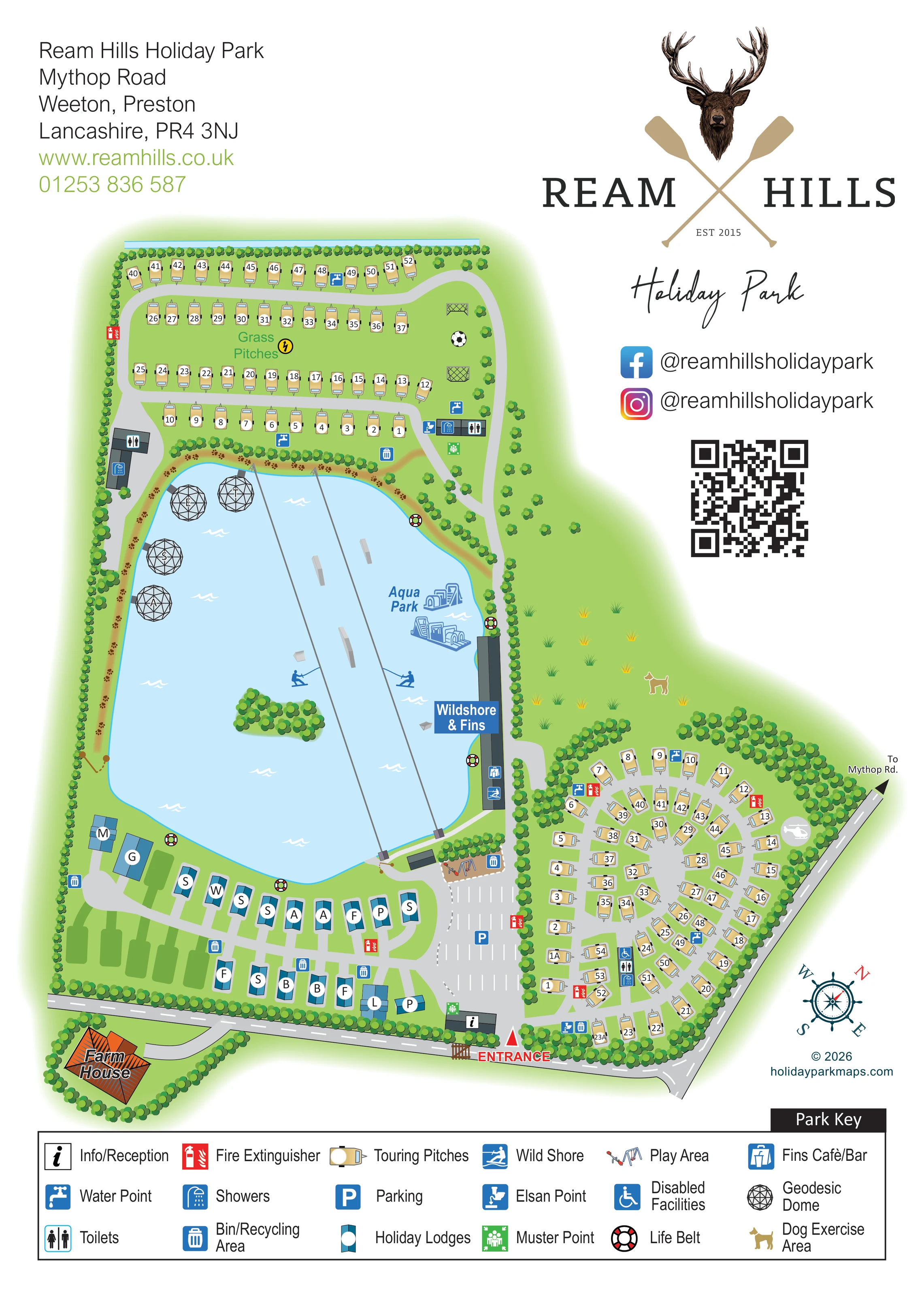
Large pale-blue lake occupying the centre of the plan, with a small wooded island, shoreline planting and illustrated watersports equipment.
ILLUSTRATED PARK MAP · P269
Ream Hills Holiday Park, Mythop Road, Weeton, Preston, Lancashire · United Kingdom
 Enlarge the map ↗
A SENSE OF THE PLACE
Ream Hills Holiday Park is set among farmland at Weeton near Blackpool. Accommodation includes lodges, a farmhouse, geodomes and touring pitches.
Serviced hardstanding spaces accommodate visiting caravans, with seasonal touring also offered. Watersports and a café add activities on site, while the Fylde Coast and surrounding Lancashire countryside provide destinations for days out.
LOOK CLOSER
Large pale-blue lake occupying the centre of the plan, with a small wooded island, shoreline planting and illustrated watersports equipment.
Rounded tree clusters define boundaries, separate accommodation groups and frame the lake, farmhouse and dog exercise area.
Wildshore & Fins is labelled on the long lakeside building. Cable lines, riders and water obstacles illustrate the watersports setting.
Named on the right-hand side of the lake and represented by blue inflatable obstacle illustrations.
A café/bar symbol is placed on the lakeside Wildshore & Fins building and identified in the key.
An information symbol marks a small building beside the entrance and main parking area.
A large marked parking area lies between the entrance, lodge roads and the right-hand touring section.
Illustrated swings and a seesaw sit beside the main parking area near the lower lake edge.
Large pale-blue lake occupying the centre of the plan, with a small wooded island, shoreline planting and illustrated watersports equipment.
Wildshore & Fins is labelled on the long lakeside building. Cable lines, riders and water obstacles illustrate the watersports setting.
Named on the right-hand side of the lake and represented by blue inflatable obstacle illustrations.
A café/bar symbol is placed on the lakeside Wildshore & Fins building and identified in the key.
An information symbol marks a small building beside the entrance and main parking area.
A large marked parking area lies between the entrance, lodge roads and the right-hand touring section.
Illustrated swings and a seesaw sit beside the main parking area near the lower lake edge.
Two goal illustrations and a football identify a recreation space within the upper touring area.
A dog symbol marks the broad green space between the lake and the right-hand touring area.
Toilet and shower symbols mark service buildings in both touring areas, including buildings on either side of the upper section.
A wheelchair symbol identifies facilities within the right-hand touring area; the map does not specify their detailed provision.
Blue tap symbols are distributed through both touring areas.
Disposal-point symbols appear beside touring-area service facilities.
Repeated blue bin symbols identify collection points around the touring, lodge and parking areas.
Red extinguisher symbols are distributed among accommodation areas.
Green assembly symbols are shown near the upper touring facilities and beside the entrance-side parking area.
Ring symbols mark several positions around the lake edge.
A red ENTRANCE label and triangular marker identify arrival at the bottom of the plan. The outer road leads to an arrow labelled To Mythop Rd.
Grey roads connect the entrance and parking with lodge branches, the lake edge and the two touring layouts.
A tan path follows substantial stretches of the planted lake margin.
Rounded tree clusters define boundaries, separate accommodation groups and frame the lake, farmhouse and dog exercise area.
READING THE MAP
A large watersports lake gives this Ream Hills Holiday Park map its organising shape. Created for the park at Weeton in Lancashire, the portrait illustration brings together touring pitches, holiday lodges, geodesic domes and a farmhouse in one clearly differentiated plan. The lake is more than a backdrop: cable lines, riders, an Aqua Park and the Wildshore & Fins lakeside building make the activity setting immediately recognisable.
Accommodation is arranged in distinct neighbourhoods around the water. Cream caravan illustrations occupy straight rows above the lake and a curved touring area to the right, while blue-roofed lodges follow smaller roads below it. Tree belts, shoreline paths and an open dog exercise area help explain the spaces between these groups.
Practical visitor information is woven into the artwork through numbered pitches, lettered lodges and repeated facility symbols. A broad key along the bottom explains these symbols, while the entrance, reception and main parking area provide a clear arrival reference. The generous branding panel, contact details and QR code give the finished page a visitor-information role as well as showing the park layout.
The plan is dominated by a pale-blue lake with a small wooded island and a planted shoreline. Two long cable lines cross the water, accompanied by rider silhouettes and obstacle drawings. The Aqua Park is labelled beside illustrated inflatables, and a long building on the right-hand shore carries the Wildshore & Fins label and café/bar and watersports symbols. Four geodesic domes form a distinctive group along the opposite lake edge.
Above the lake, touring pitches sit in parallel rows around a green centre labelled Grass Pitches. Football goals and a ball illustration identify a recreation space at one end. Roads curve around this section, with toilet and shower buildings, water points, disposal facilities and other service symbols placed nearby. The second touring area, to the right of the lake, uses curved lanes and angled pitch arrangements. Its facility cluster includes a wheelchair symbol, toilets and showers.
Below the water, blue-roofed lodges follow branching access roads, with white circular letters distinguishing them from the numbered touring units. The Farm House sits separately beside the lower approach road. Arrival is marked by a red ENTRANCE label near reception and a sizeable car park. A small illustrated play area occupies the space between parking and the lake, while the dog exercise symbol identifies the open green area above the right-hand touring section.
The single portrait artwork combines the plan with contact information, prominent Ream Hills branding, social media handles and a QR code. A full-width pictorial key explains accommodation, facilities and safety markers. A decorative compass accompanies the outer road’s direction towards Mythop Road, completing the page’s orientation information.
KEEP EXPLORING
Chosen for shared landscapes, accommodation or facilities.
 Explore the map ↗
United Kingdom
Illustrated farm campsite map with touring pitches, pods, camping fields and a riverside dog-walk route.
 Explore the map ↗
United Kingdom
Woodland park map with mixed pitches, bell tents, lodges and a fishing lake.
 Explore the map ↗
United Kingdom
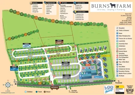
Colour-coded camping and touring sections, illustrated glamping units and a detailed amenities hub at Burns Farm.
Features may come from the sample artwork, its key or published park information. Approximate numbers describe the drawing and may cover only part of a park. They are intended to help you compare map examples. Current facilities and booking information should be checked with the park.
TAKE A CLOSER LOOK
View the illustrated map in detail or choose a file to download. These are sample maps; contact the park for current visitor information.


LET’S MAP YOUR PARK
For a map quotation, find your park and draw a rough boundary around it. The area you select helps us work out the design time and price.
Draw your park for a quote ↗Or talk to our map designers
01751 473136