
Playing field
A substantial open green occupies the lower-left corner, edged by trees, fencing and the roadside boundary.
ILLUSTRATED PARK MAP · P272
Hardacre Lane, Rimington, Clitheroe · United Kingdom
 Enlarge the map ↗
A SENSE OF THE PLACE
Rimington Holiday Park is based at Hardacre Lane, Rimington, Clitheroe. The countryside park near Clitheroe overlooks the Ribble Valley towards Pendle Hill. Holiday lodges and static caravans are marketed for ownership.
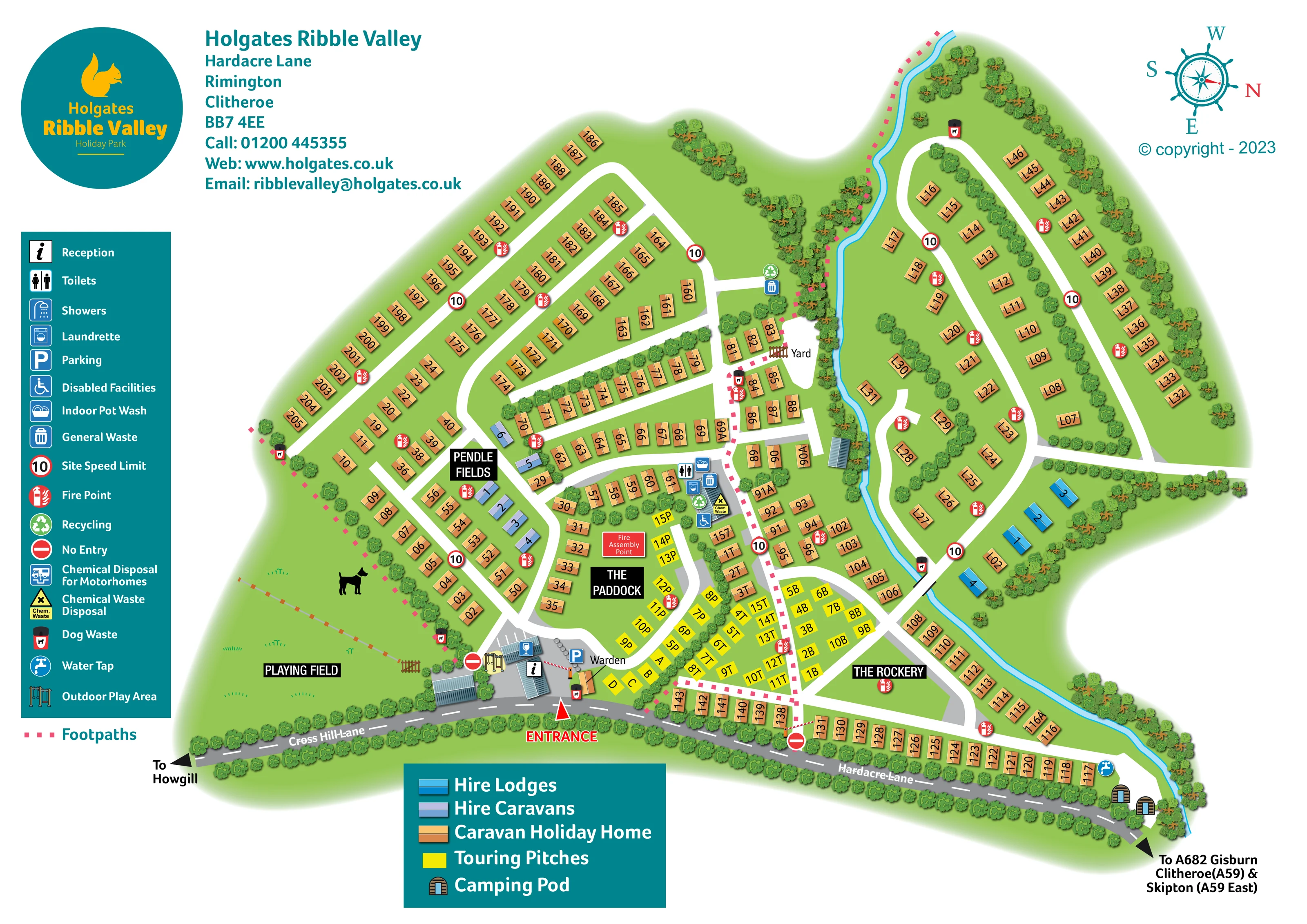
The map brings the site layout and its access routes together in one view, providing a reference for understanding the arrangement of the grounds.
LOOK CLOSER
A substantial open green occupies the lower-left corner, edged by trees, fencing and the roadside boundary.
A narrow light-blue watercourse separates the two main accommodation areas, then bends towards the camping pods at the lower-right edge.
Repeated illustrated trees define the park boundary, follow the watercourse and divide accommodation rows into smaller groups.
Three prominent black-backed area labels provide recognisable destinations within the accommodation layout.
Reception is marked within the building cluster immediately inside the entrance, alongside a barrier and paved arrival space.
A labelled warden location sits beside the entrance buildings and the lower edge of the touring area.
A blue parking symbol and drawn parking bays identify parking within the entrance complex.
A central service-building cluster beside the touring pitches carries toilet, shower, laundry and indoor pot-wash symbols.
Reception is marked within the building cluster immediately inside the entrance, alongside a barrier and paved arrival space.
A labelled warden location sits beside the entrance buildings and the lower edge of the touring area.
A blue parking symbol and drawn parking bays identify parking within the entrance complex.
A central service-building cluster beside the touring pitches carries toilet, shower, laundry and indoor pot-wash symbols.
The wheelchair symbol identifies facilities beside the central service block; the map does not specify their detailed provision.
Illustrated play equipment is positioned beside the entrance buildings and the edge of the playing field.
A substantial open green occupies the lower-left corner, edged by trees, fencing and the roadside boundary.
A narrow light-blue watercourse separates the two main accommodation areas, then bends towards the camping pods at the lower-right edge.
Repeated illustrated trees define the park boundary, follow the watercourse and divide accommodation rows into smaller groups.
Three prominent black-backed area labels provide recognisable destinations within the accommodation layout.
A labelled yard with a gate illustration lies beside the watercourse near the centre of the plan.
General waste and recycling symbols appear at service locations; dog-waste bins are distributed around routes and boundaries.
A yellow chemical-waste symbol is placed beside the central service building.
A separate motorhome chemical-disposal symbol is included in the facility key, but its location is not clearly established in the plan.
A water-tap symbol is shown near the camping pods at the lower-right end of the park.
Red fire-point symbols recur through the accommodation areas. A larger red Fire Assembly Point label is positioned beside The Paddock.
The entrance is prominently marked along the lower roadside boundary. Cross Hill Lane and Hardacre Lane are labelled, with outward directions to Howgill, the A682 at Gisburn, Clitheroe and Skipton.
White internal roads form connected loops and branches. A clearly drawn bridge crosses the watercourse to the right-hand accommodation area.
Pink dashed footpaths run through the lower central pitches, past the yard and along parts of the watercourse and left-hand boundary.
Circular speed-limit symbols marked 10 recur along internal roads, while no-entry symbols and barrier illustrations identify particular access points.
READING THE MAP
This illustrated map presents a sizeable countryside holiday park at Hardacre Lane in Rimington, near Clitheroe. Branded Holgates Ribble Valley Holiday Park, the artwork brings a varied accommodation layout together with the entrance, visitor facilities and local road connections in one landscape-format view.
A winding blue watercourse gives the plan its defining shape, separating the extensive caravan holiday-home rows from a curved accommodation area on the right. Trees follow the water and surround much of the site, while an open playing field creates a contrasting green space beside the arrival buildings. Orange holiday homes, yellow touring pitches, pale-blue hire caravans, bright-blue hire lodges and illustrated camping pods each have their own visual identity.
The map is particularly useful as a sample for parks that need to explain several accommodation types without losing the overall layout. Its two separate keys, prominent entrance marker, named internal areas and clearly differentiated roads and footpaths give visitors several ways to recognise where they are going.
The plan is arranged around a lower roadside boundary labelled Cross Hill Lane and Hardacre Lane. A large red entrance marker directs attention to a compact arrival complex containing reception, parking, a warden location and nearby outdoor play equipment. The playing field extends to the left of this cluster, framed by trees and fencing.
From the entrance, white internal roads branch into the accommodation areas. On the left, long rows of orange caravan holiday homes follow connected loops and narrower access roads. Pale-blue hire caravans are grouped around Pendle Fields. Yellow touring pitches occupy the lower central part of the plan, including the curved edge of The Paddock and neighbouring rows. Beside them, a service building is marked with toilets, showers, laundrette, indoor pot wash, disabled facilities, waste, recycling and chemical-waste symbols.
The blue watercourse runs down the middle before bending towards the lower-right boundary. A road bridge provides a clear connection to the long right-hand loop, where orange holiday homes are interspersed with planted divisions. A small group of bright-blue hire lodges sits near the outer tree belt. Two arched camping-pod illustrations appear at the far end of the grounds beside a water-tap symbol.
Pink dashed footpaths provide a second route network through the central pitches, past the yard and along parts of the boundary. Fire points and dog-waste bins are distributed through the plan, with a labelled fire assembly point beside The Paddock. Separate teal panels explain facilities and accommodation colours. The upper-left branding block and upper-right compass complete the composition. The overview and four overlapping detail views show the same single-page artwork, not additional park sections.
KEEP EXPLORING
Chosen for shared landscapes, accommodation or facilities.
 Explore the map ↗
United Kingdom
A woodland estate park map combining caravan loops, touring pitches, riverside paths and Bruce’s Cave landmarks.
 Explore the map ↗
United Kingdom
Woodland park map with mixed pitches, bell tents, lodges and a fishing lake.
 Explore the map ↗
United Kingdom
Riverside park map with named pitch fields, illustrated huts and a paw-print dog walk.
Features may come from the sample artwork, its key or published park information. Approximate numbers describe the drawing and may cover only part of a park. They are intended to help you compare map examples. Current facilities and booking information should be checked with the park.
The artwork shows Holgates Ribble Valley Holiday Park at the address catalogued as Rimington Holiday Park.
LET’S MAP YOUR PARK
For a map quotation, find your park and draw a rough boundary around it. The area you select helps us work out the design time and price.
Draw your park for a quote ↗Or talk to our map designers
01751 473136