
Tree-lined boundaries and planted divisions
Repeated outlined tree canopies enclose the park, separate accommodation groups and define the recreation fields and walking circuit.
ILLUSTRATED PARK MAP · P275
Main Street, Ballygillaroe, Redcross, Co. Wicklow · Ireland
 Enlarge the map ↗
A SENSE OF THE PLACE
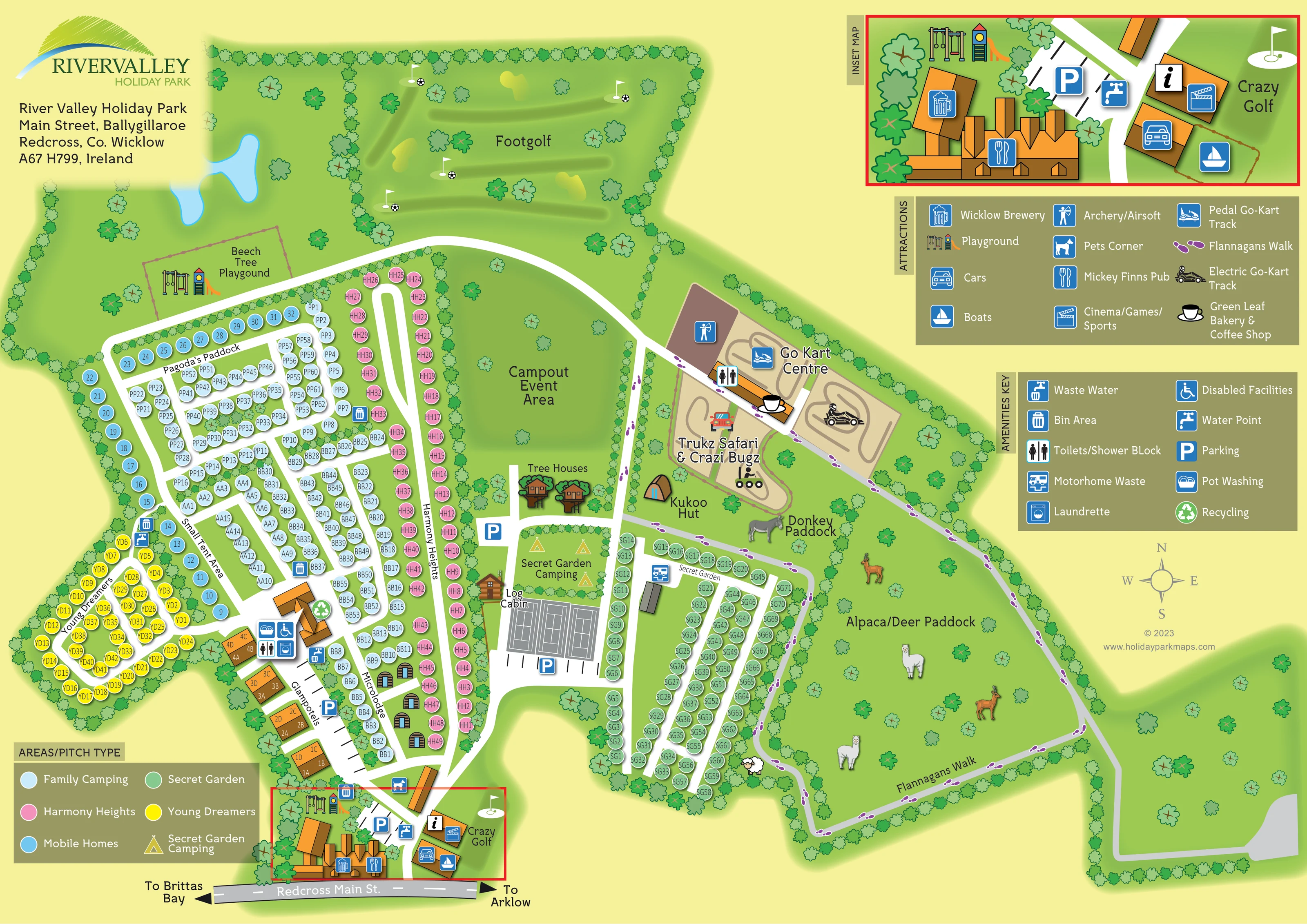
River Valley Caravan Park is located at Redcross in County Wicklow. Its camping grounds are arranged across meadow areas divided by trees and hedges, with some terraced sections and views towards the hills.
Touring spaces include paved pitches, and rental accommodation is also listed. The map helps visitors understand the different areas of the park and its relationship to the village setting.
LOOK CLOSER
Repeated outlined tree canopies enclose the park, separate accommodation groups and define the recreation fields and walking circuit.
An irregular blue water feature appears in the north-western green space, partly beneath the address panel. It is not named as a river or lake.
A large northern recreation field is labelled Footgolf and illustrated with sweeping fairway-like bands, flags, footballs and scattered trees.
Play equipment appears in the fenced Beech Tree Playground north-west of the pitches and again beside the entrance buildings.
Labelled beside the entrance activity buildings and enlarged in the entrance inset.
The eastern activity complex contains separately illustrated pedal and electric go-kart tracks, identified through the attractions key.
A named driving attraction below the Go Kart Centre uses winding tracks and small truck and buggy illustrations.
The blue archery symbol marks a brown activity area immediately north-west of the kart tracks; its meaning is given in the key.
A large northern recreation field is labelled Footgolf and illustrated with sweeping fairway-like bands, flags, footballs and scattered trees.
Play equipment appears in the fenced Beech Tree Playground north-west of the pitches and again beside the entrance buildings.
Labelled beside the entrance activity buildings and enlarged in the entrance inset.
The eastern activity complex contains separately illustrated pedal and electric go-kart tracks, identified through the attractions key.
A named driving attraction below the Go Kart Centre uses winding tracks and small truck and buggy illustrations.
The blue archery symbol marks a brown activity area immediately north-west of the kart tracks; its meaning is given in the key.
A broad open green occupies the centre of the park, between Harmony Heights and the eastern activity complex.
Named animal areas occupy the eastern side, with donkey, alpaca and deer illustrations making their purpose immediately recognisable.
The keyed Pets Corner symbol appears on a building near the entrance, distinct from the larger animal paddocks.
Purple footprint symbols trace the walking route through the activity side and around the large eastern paddock.
Three adjacent grey courts with white line markings sit beside the Log Cabin and central parking. The artwork does not label their sport.
A beer-mug symbol identifies a building in the village-facing entrance complex, shown again in the inset.
The keyed cutlery symbol marks the large entrance building adjoining the brewery.
A prominent cup illustration marks a building at the Go Kart Centre; the attractions key supplies the venue name.
A clapperboard symbol identifies an entrance-side building, with the combined activity description provided in the key.
Car and boat symbols mark two entrance-side attractions. Their exact operating format is not specified by the map.
A black information symbol appears on an entrance-side building in both the main plan and its enlarged inset.
A central service cluster near the Glampotels shows toilets/showers, pot washing, a laundrette and disabled facilities. Another toilet/shower symbol appears at the activity centre.
Repeated bin and water-point symbols serve the accommodation areas. Recycling and waste-water symbols appear near the main service cluster, while a motorhome-waste symbol is located in Secret Garden.
Blue P symbols and marked bays identify parking at the entrance, beside the Glampotels, near the Tree Houses and beside the sports courts.
The main entrance meets Redcross Main St. along the bottom of the plan, with directional arrows towards Brittas Bay and Arklow.
Repeated outlined tree canopies enclose the park, separate accommodation groups and define the recreation fields and walking circuit.
An irregular blue water feature appears in the north-western green space, partly beneath the address panel. It is not named as a river or lake.
The supplied park context describes meadow camping areas divided by trees and hedges, some terraced sections and views towards the hills.
READING THE MAP
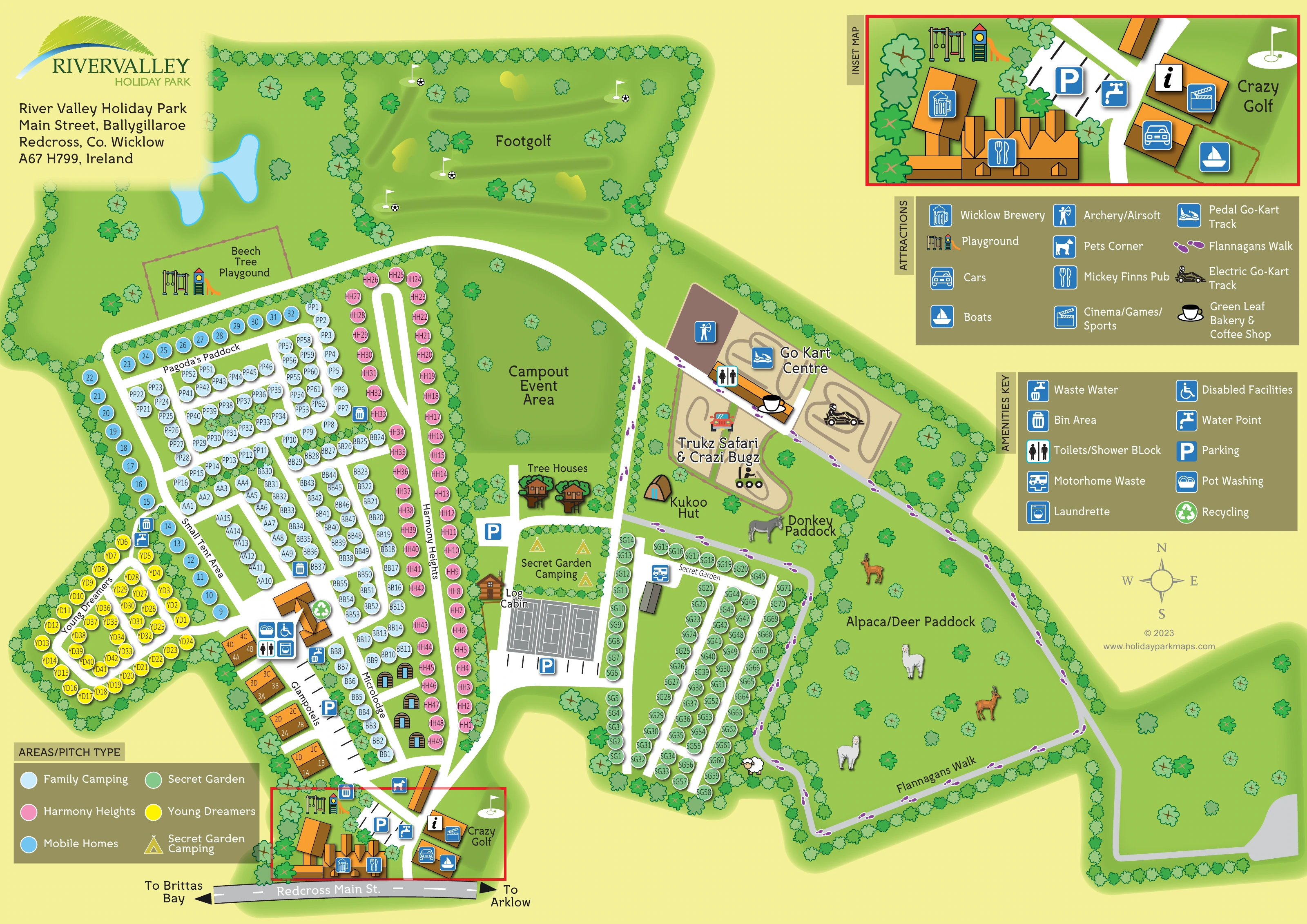
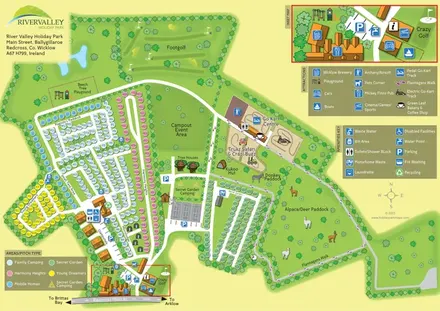
This illustrated map of River Valley Holiday Park places a varied camping and glamping site within its village setting at Redcross, County Wicklow. Redcross Main Street forms the arrival edge, while the plan opens northwards into tree-lined accommodation areas, recreation fields and a substantial activity landscape.
The map’s clearest organising device is its colour-coded accommodation system. Family Camping, Young Dreamers, Harmony Heights, Mobile Homes and Secret Garden each have a distinct marker colour, helping visitors recognise their area before following individual pitch references. Glampotels, Microlodges, Tree Houses, a Log Cabin and the Kukoo Hut are drawn as buildings or small accommodation illustrations rather than standard pitch circles.
Beyond the accommodation, the artwork gives considerable space to the park’s character: footgolf, playgrounds, go-kart tracks, animal paddocks and Flannagans Walk all have a visible place in the plan. A separate entrance enlargement brings the village-facing buildings and attractions into focus. The result is a useful example for parks that need one map to explain arrival, different accommodation neighbourhoods and a broad range of visitor activities.
The main plan is arranged around a southern entrance from Redcross Main Street, with arrows indicating the directions of Brittas Bay and Arklow. A red-framed section at the entrance is repeated as a larger inset in the upper-right corner, making the information point, parking, brewery, pub and nearby attractions easier to distinguish without enlarging the whole park.
Accommodation occupies the western half of the map and a separate Secret Garden block to the east of the central road. Pale-blue Family Camping markers form rows divided by white lanes and planted boundaries. Stronger blue Mobile Home markers follow the western perimeter, yellow Young Dreamers markers fill a smaller loop, and pink Harmony Heights markers line a long central road. The Small Tent Area is named within the western block. Near the entrance, orange-roofed Glampotels and rounded Microlodge illustrations introduce a different visual treatment for rental accommodation.
The central open space contains the Campout Event Area, two illustrated Tree Houses, Secret Garden Camping, a Log Cabin and three marked sports courts. Farther north, the Footgolf field is drawn with broad green strips, flags and footballs, beside the Beech Tree Playground and an unlabelled blue water feature.
The eastern activity complex includes archery/airsoft, pedal and electric kart tracks, Trukz Safari & Crazi Bugz and the coffee-shop symbol. Purple footprints trace Flannagans Walk around the donkey and alpaca/deer paddocks. Blue pictograms locate practical services, including washing facilities, laundry, water, waste disposal and parking. Three separate keys explain accommodation colours, attractions and amenities. This is a single map artwork; the entrance inset is an enlargement of an existing part of the plan, not an additional park section.
KEEP EXPLORING
Chosen for shared landscapes, accommodation or facilities.
 Explore the map ↗
Ireland
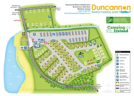
Beachside park plan with colour-coded mobile homes, touring/camping areas, glamping cabins and grouped service symbols.
 Explore the map ↗
United Kingdom
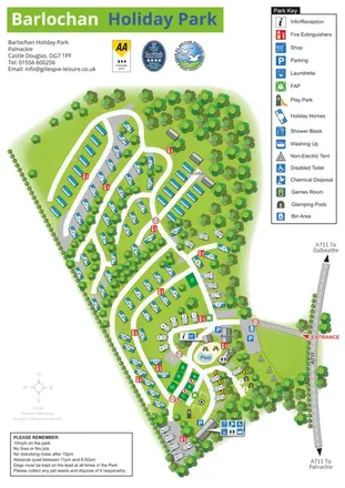
A wooded, mixed-accommodation park plan with winding lanes, a pool, camping areas and a clear facility key.
 Explore the map ↗
United Kingdom
Woodland-framed Barnsoul map with mixed accommodation, shared facilities and paw-marked walking routes.
Features may come from the sample artwork, its key or published park information. Approximate numbers describe the drawing and may cover only part of a park. They are intended to help you compare map examples. Current facilities and booking information should be checked with the park.
TAKE A CLOSER LOOK
View the illustrated map in detail or choose a file to download. These are sample maps; contact the park for current visitor information.


LET’S MAP YOUR PARK
For a map quotation, find your park and draw a rough boundary around it. The area you select helps us work out the design time and price.
Draw your park for a quote ↗Or talk to our map designers
01751 473136
 rivervvalley_large.png