
Riverside boundary
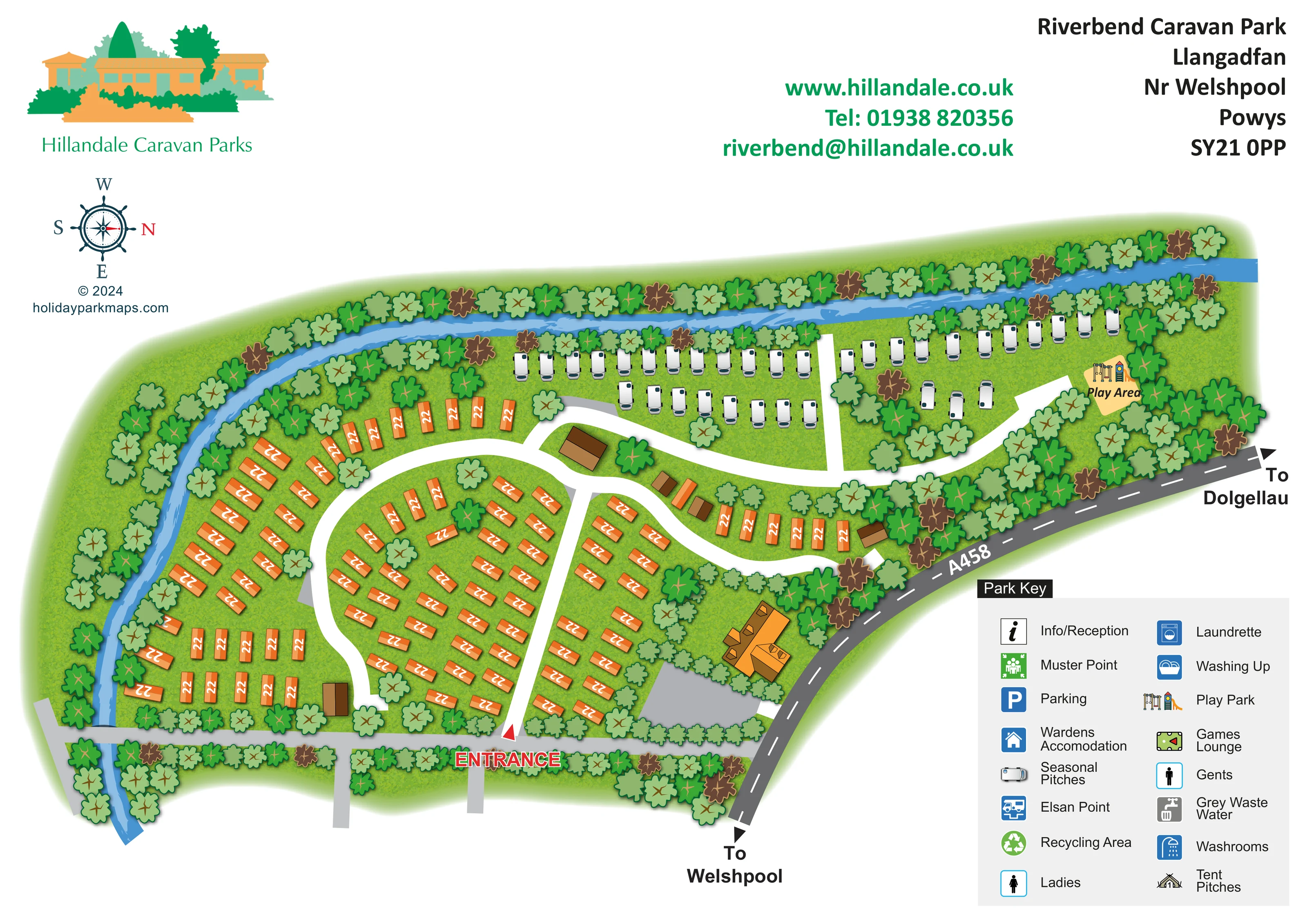
A blue river follows the upper edge, bends down the left side and continues beyond the lower boundary.
ILLUSTRATED PARK MAP · P276
Riverbend Caravan Park, Llangadfan, Nr Welshpool, Powys · United Kingdom
 Enlarge the map ↗
A SENSE OF THE PLACE
Riverbend Caravan Park lies beside the River Banwy at Llangadfan in Mid Wales. The riverside countryside setting provides a quieter holiday base near Welshpool.
Fishing rights on the river are part of the park's offering, with a children's play area and wildlife adding interest on site. The map illustrates how the caravan plots and access routes follow the bend of the river.
LOOK CLOSER
A blue river follows the upper edge, bends down the left side and continues beyond the lower boundary.
Dense illustrated trees border the river and public road, with additional planting between accommodation groups.
A labelled play area with swings and a slide stands at the upper-right end of the park, beside the seasonal pitches.
A red arrow and prominent ENTRANCE label identify the lower-central arrival point.
The A458 follows the right-hand boundary, with arrows towards Welshpool at the bottom and Dolgellau at the right.
Broad white roads form a curved western loop, a central dividing route and branches serving the eastern and seasonal sections.
A grey route crosses the river near the lower-left corner; its onward destination is not labelled.
A blue river follows the upper edge, bends down the left side and continues beyond the lower boundary.
The park context identifies the river as the Banwy and describes fishing rights as part of the park's offering; fishing locations are not marked.
Dense illustrated trees border the river and public road, with additional planting between accommodation groups.
A labelled play area with swings and a slide stands at the upper-right end of the park, beside the seasonal pitches.
A red arrow and prominent ENTRANCE label identify the lower-central arrival point.
The A458 follows the right-hand boundary, with arrows towards Welshpool at the bottom and Dolgellau at the right.
Broad white roads form a curved western loop, a central dividing route and branches serving the eastern and seasonal sections.
A grey route crosses the river near the lower-left corner; its onward destination is not labelled.
An information/reception symbol is included in the key, without a clearly identifiable placement on the plan.
Parking is listed in the key. A grey apron is drawn beside the large lower-right building, but it is not explicitly marked with the parking symbol.
The key includes wardens' accommodation, without identifying a particular building.
The key lists washrooms, ladies, gents, a laundrette and washing-up facilities; their locations are not clearly marked.
Elsan point, grey waste water and recycling area symbols appear in the key, rather than at identifiable positions within the plan.
A pool-table pictogram represents the games lounge in the key.
A green muster-point symbol is included in the key, but its site position is not shown clearly.
READING THE MAP
This illustrated map of Riverbend Caravan Park makes the riverside shape of the site its central organising feature. Set at Llangadfan, near Welshpool in Powys, the park is shown between a sweeping blue river and the diagonal line of the A458. Tree-lined boundaries give the plan a strong countryside character, while clear white internal roads reveal how the accommodation groups connect.
Orange static caravans fill the broader western and central sections, contrasting with white seasonal caravans arranged along the upper riverside edge. At the eastern end, a labelled play area provides a memorable destination beside the smaller caravan groups. A red entrance marker, directions towards Welshpool and Dolgellau, and a compass help readers relate the illustrated grounds to their approach.
The landscape-format artwork also accommodates Hillandale branding, contact details and a substantial two-column park key without crowding the site plan. It is a useful sample for caravan parks that need to explain a curved, tree-rich layout and distinguish accommodation areas through colour and recognisable symbols.
The plan follows an irregular riverside footprint, broad at the western end and tapering towards the play area in the east. A blue river runs across the upper boundary before turning down the left side. Dense tree canopies line both banks and the road-facing edge, with smaller groups of trees breaking up the accommodation areas. Layered blues suggest flowing water, while mottled green grass gives the grounds texture.
The main accommodation is represented by orange rectangular static-caravan symbols. These form an outer arc beside the river, closely spaced central groups and shorter rows towards the A458. White seasonal-caravan symbols occupy a separate strip across the upper part of the map, with additional positions near the playground. The colour contrast makes the two areas legible without relying solely on text.
Broad white roads connect the groups through a western loop and branching central and eastern routes. The entrance is called out along the lower edge with red lettering and an arrow. A grey lower-boundary route crosses the river at the left, while the dark diagonal A458 carries clear arrows towards Welshpool and Dolgellau. Several roofed buildings are illustrated, including a larger orange-roofed building beside a grey apron near the lower-right boundary, but their functions are not individually labelled.
The lower-right key includes reception, parking, wardens' accommodation, washing and toilet facilities, waste services, recycling, a games lounge, a muster point and tent pitches. These entries explain the symbol vocabulary rather than establish their positions on the plan. The play area is directly illustrated and labelled. The accompanying detail view enlarges this same key and adjacent road frontage; it is not a separate park section or additional site.
KEEP EXPLORING
Chosen for shared landscapes, accommodation or facilities.
 Explore the map ↗
United Kingdom
Illustrated caravan park plan with woodland and riverside walks, fishing pools and wildlife panels.
 Explore the map ↗
United Kingdom
A woodland estate park map combining caravan loops, touring pitches, riverside paths and Bruce’s Cave landmarks.
 Explore the map ↗
United Kingdom
Woodland park map with mixed pitches, bell tents, lodges and a fishing lake.
Features may come from the sample artwork, its key or published park information. Approximate numbers describe the drawing and may cover only part of a park. They are intended to help you compare map examples. Current facilities and booking information should be checked with the park.
LET’S MAP YOUR PARK
For a map quotation, find your park and draw a rough boundary around it. The area you select helps us work out the design time and price.
Draw your park for a quote ↗Or talk to our map designers
01751 473136