
Lodge Lake
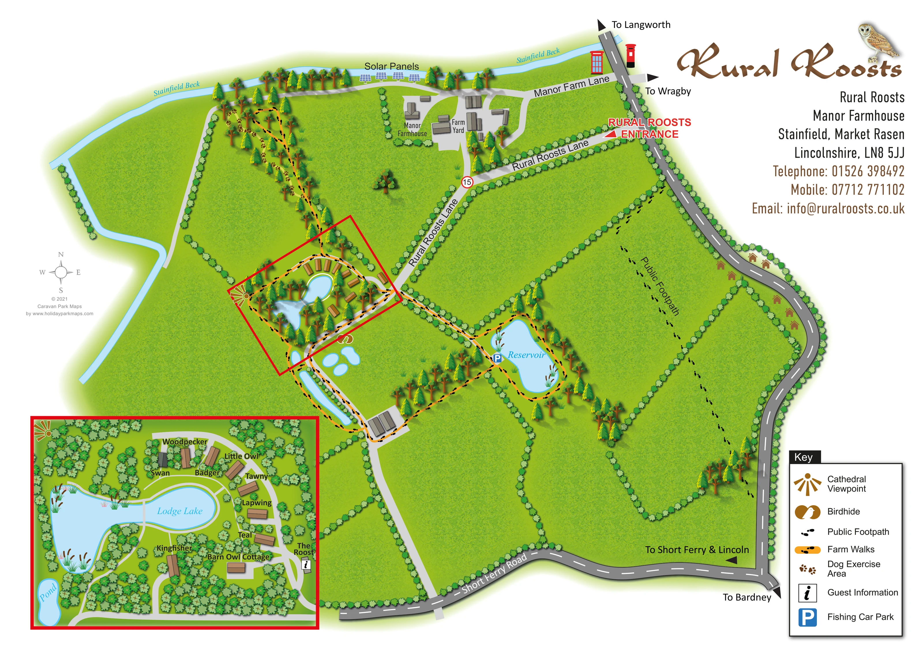
An irregular, reed-fringed lake forming the centre of the accommodation cluster, with paths following much of its edge.
ILLUSTRATED PARK MAP · P587
Rural Roosts, Manor Farmhouse, Stainfield, Market Rasen, Lincolnshire · United Kingdom
 Enlarge the map ↗
A SENSE OF THE PLACE
Rural Roosts offers self-catering lodges on a working farm at Stainfield near the Lincolnshire Wolds. Wildflower meadows, wetlands and farmland surround the accommodation.
Two coarse-fishing lakes are reserved for lodge guests, and dog-friendly accommodation is available. Walking around the grounds and surrounding countryside adds to the appeal of this rural retreat.
LOOK CLOSER
An irregular, reed-fringed lake forming the centre of the accommodation cluster, with paths following much of its edge.
A separate waterbody east of the lodges, surrounded by a marked farm-walk circuit and tree planting.
A labelled Pond appears in the lodge inset; the wider plan also shows several small pools and an elongated waterbody south of the accommodation.
A pale-blue watercourse runs across the northern edge and bends down the western side of the farm landscape.
Large green fields are divided by repeated hedge symbols, with wooded strips around the accommodation, water and walking routes.
Orange routes carrying black footprint symbols connect the lodge area, northern wooded strip, southern farm buildings and reservoir circuit.
A separately labelled black-footprint route crosses the eastern fields, distinct from the orange farm walks.
Brown paw-print symbols identify the wooded strip north of the lodge cluster, using the symbol explained in the key.
An irregular, reed-fringed lake forming the centre of the accommodation cluster, with paths following much of its edge.
A separate waterbody east of the lodges, surrounded by a marked farm-walk circuit and tree planting.
A labelled Pond appears in the lodge inset; the wider plan also shows several small pools and an elongated waterbody south of the accommodation.
A pale-blue watercourse runs across the northern edge and bends down the western side of the farm landscape.
Large green fields are divided by repeated hedge symbols, with wooded strips around the accommodation, water and walking routes.
Orange routes carrying black footprint symbols connect the lodge area, northern wooded strip, southern farm buildings and reservoir circuit.
A separately labelled black-footprint route crosses the eastern fields, distinct from the orange farm walks.
Brown paw-print symbols identify the wooded strip north of the lodge cluster, using the symbol explained in the key.
A brown birdhide symbol is positioned just south-east of the lodge cluster near the smaller waterbodies.
A fan-shaped brown viewpoint symbol appears at the western edge of the lodge area and is repeated in the enlarged inset.
The Roost is labelled beside the accommodation access lane, with a boxed information symbol.
A blue parking symbol marks the western side of the reservoir, where the access route and walking circuit meet.
The farmhouse and a group of farm-yard buildings sit north of the holiday accommodation, served by Manor Farm Lane.
A labelled row of blue panel arrays is shown beside the northern beck and farm track.
A prominent red label and arrow identify the entrance from the eastern road onto Rural Roosts Lane.
Manor Farm Lane, Rural Roosts Lane and Short Ferry Road are named. Edge arrows point towards Langworth, Wragby, Bardney, and Short Ferry and Lincoln.
The supplied park context describes two coarse-fishing lakes reserved for lodge guests. This use provides context for the mapped lakes and fishing car park but is not stated in full on the artwork.
READING THE MAP
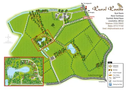
This illustrated map of Rural Roosts places a small lakeside lodge retreat within the wider landscape of a Lincolnshire farm. Rather than filling the page with accommodation plots, it gives space to fields, hedgerows, woodland, Stainfield Beck and the routes that connect them. Lodge Lake anchors the holiday accommodation, while a separate reservoir and several smaller waterbodies help explain the grounds beyond the lodges.
The design works at two levels. The main plan shows arrival from the surrounding roads, the farmhouse and farm yard, and walking routes through the estate. A red-framed enlargement brings the accommodation into focus, identifying the individually named lodges, Barn Owl Cottage and guest information at The Roost. Visitors can therefore understand the broader setting without losing the detail needed to find their accommodation.
Orange farm walks, a separately marked public footpath, a dog exercise area, a birdhide and a cathedral viewpoint give this sample a distinctive countryside emphasis. The owl wordmark, blue water and varied green planting support that character without obscuring the practical route information.
The main plan presents Rural Roosts as a compact accommodation area within a much larger pattern of fields and farm routes. Stainfield Beck follows the northern edge before bending down the west, while the surrounding road network frames the eastern and southern sides. Destination arrows point towards Langworth, Wragby, Bardney, and Short Ferry and Lincoln. A bold red entrance label directs attention to Rural Roosts Lane, which leads between hedgerows towards the lodges. Manor Farm Lane serves the separately labelled farmhouse and farm yard, with solar panels illustrated near the beck.
Left of centre, Lodge Lake sits within a wooded accommodation cluster. A red outline identifies the area enlarged in the lower-left inset. Here, tan-roofed lodges follow a loose arc around the water, and names such as Woodpecker, Little Owl, Tawny, Lapwing and Kingfisher provide individual destinations. Barn Owl Cottage sits towards the south, while The Roost carries the guest-information symbol beside the access lane. Pale-grey paths trace the lake edge and connect the buildings; reeds and dense tree symbols reinforce the sheltered lakeside setting.
Beyond this cluster, orange farm walks extend into the northern wooded strip and around the eastern reservoir. Paw prints identify the dog exercise area, and a birdhide symbol appears near the smaller pools south-east of the lodges. A blue parking marker locates the fishing car park beside the reservoir. The public footpath crosses the eastern fields using black footprints without the orange route band.
A boxed key at lower right explains these symbols. The upper-right branding and contact panel balances the detailed inset, while a small compass completes the orientation aids. The close-up views show portions of this same sheet, not additional accommodation areas.
KEEP EXPLORING
Chosen for shared landscapes, accommodation or facilities.
 Explore the map ↗
United Kingdom
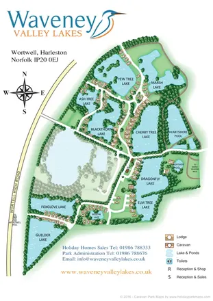
Illustrated lakeside park plan with numbered holiday units, leisure buildings and a looping Woodland Walk.
 Explore the map ↗
United Kingdom
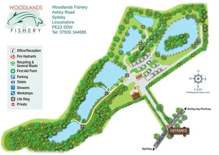
Illustrated lakeside caravan and lodge park map with numbered homes, wooded banks and a central reception cluster.
 Explore the map ↗
United Kingdom
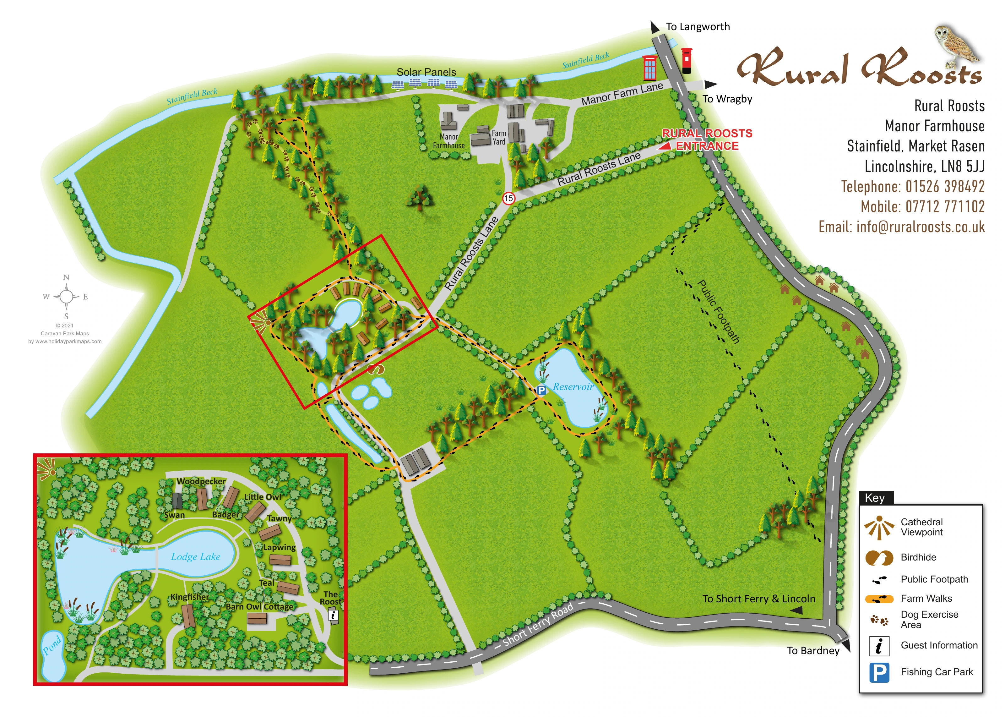
Illustrated fishery map with lakeside routes, wooded waters and a compact touring area.
Features may come from the sample artwork, its key or published park information. Approximate numbers describe the drawing and may cover only part of a park. They are intended to help you compare map examples. Current facilities and booking information should be checked with the park.
TAKE A CLOSER LOOK
View the illustrated map in detail or choose a file to download. These are sample maps; contact the park for current visitor information.


LET’S MAP YOUR PARK
For a map quotation, find your park and draw a rough boundary around it. The area you select helps us work out the design time and price.
Draw your park for a quote ↗Or talk to our map designers
01751 473136
 ruralroosts_large.png