
Formal gardens
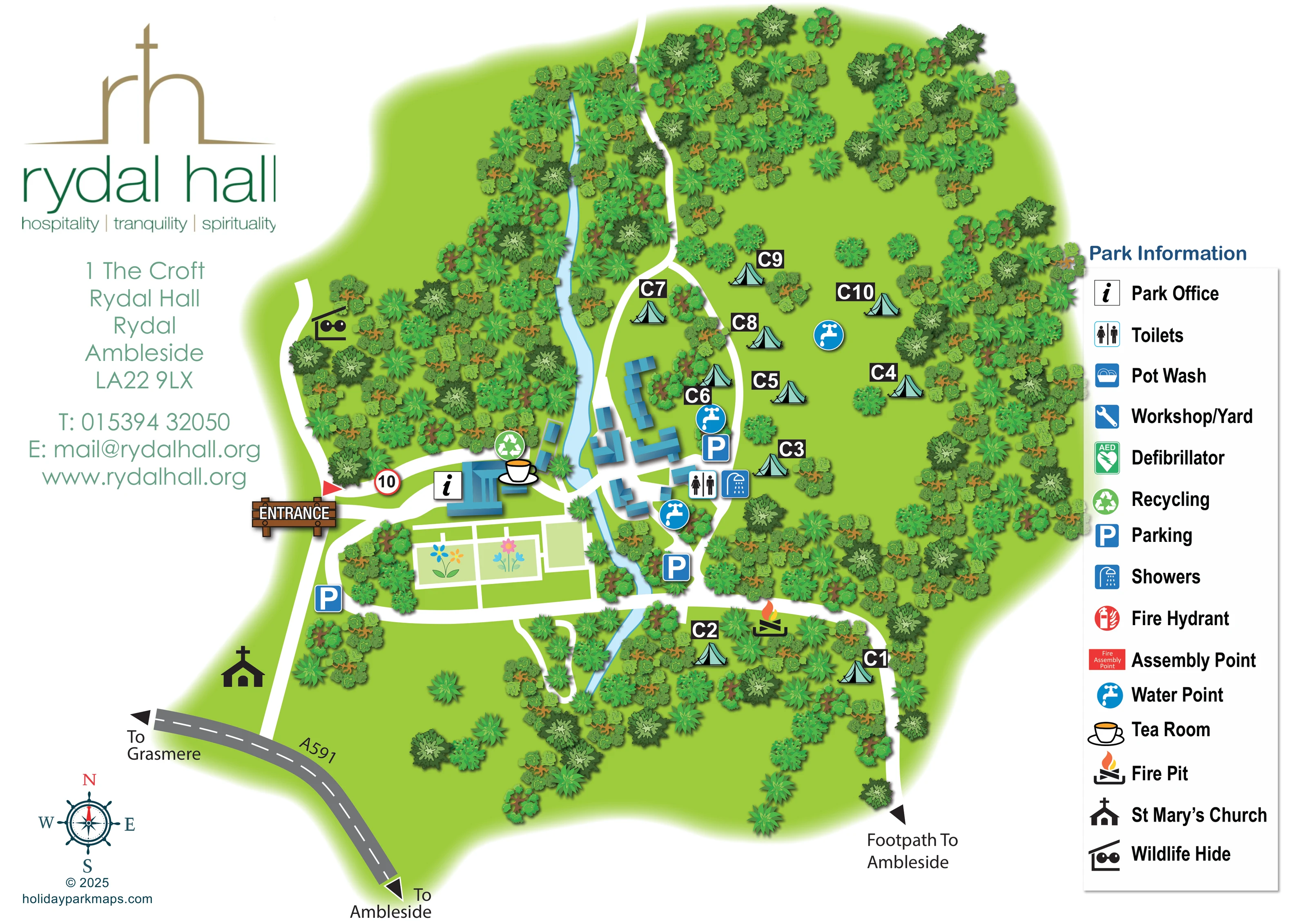
Rectangular pale-green beds, oversized flower illustrations and a rectilinear white path network form a garden area south of the main buildings.
ILLUSTRATED PARK MAP · P283
Rydal Hall, Ambleside, Cumbria · United Kingdom
 Enlarge the map ↗
A SENSE OF THE PLACE
Rydal Hall is based at Ambleside, Cumbria. The estate describes its purpose as Christian hospitality and welcomes visitors for accommodation, events and its cafe. Camping pitches, glamping pods, woodland cabins, cottages and hall bedrooms are offered.
Rydal Hall is a Lake District retreat with gardens, woodland and waterfalls.
LOOK CLOSER
Rectangular pale-green beds, oversized flower illustrations and a rectilinear white path network form a garden area south of the main buildings.
Dense clusters of varied tree crowns surround the grounds, line the stream and separate camping clearings.
A pale-blue watercourse runs from the upper woodland through the central building area and towards the southern grounds, with white routes crossing it.
An information symbol marks the office at the central building group just inside the entrance.
A large cup-and-saucer symbol identifies the tea room beside the central buildings, west of the stream.
Paired toilet and shower symbols sit beside the buildings on the eastern side of the stream, close to the camping area.
Repeated blue tap symbols mark water points around the central facilities and within the main camping lawn.
Blue parking symbols identify areas near the approach, central buildings and camping facilities.
An information symbol marks the office at the central building group just inside the entrance.
A large cup-and-saucer symbol identifies the tea room beside the central buildings, west of the stream.
Paired toilet and shower symbols sit beside the buildings on the eastern side of the stream, close to the camping area.
Repeated blue tap symbols mark water points around the central facilities and within the main camping lawn.
Blue parking symbols identify areas near the approach, central buildings and camping facilities.
A green recycling symbol appears beside the tea room and entrance-side building group.
A flame-and-logs symbol marks a fire pit beside the southern woodland camping locations.
A black hide-and-binoculars pictogram appears along a woodland path northwest of the entrance.
A church pictogram marks St Mary’s beside the approach from the A591.
Rectangular pale-green beds, oversized flower illustrations and a rectilinear white path network form a garden area south of the main buildings.
Dense clusters of varied tree crowns surround the grounds, line the stream and separate camping clearings.
A pale-blue watercourse runs from the upper woodland through the central building area and towards the southern grounds, with white routes crossing it.
A wooden-style ENTRANCE sign marks the arrival point on the western side of the estate.
The curved road along the lower-left edge is labelled A591, with directional arrows to Grasmere and Ambleside.
A separate white path exits the southeastern grounds with an arrow and the label Footpath To Ambleside.
Broad white routes connect the entrance, buildings, gardens, stream crossings, camping areas and woodland.
Listed in the key, without a clearly identifiable corresponding marker on the plan.
A spanner symbol is explained in the key, but its position is not clearly marked in the artwork.
The key includes a green AED symbol; no definite location is visible on the plan.
Included as a red safety symbol in the key, without a clearly visible matching location.
A red Fire Assembly Point box appears in the key. The red triangular marker near the entrance is not sufficient to establish a matching location.
The estate information describes waterfalls as part of Rydal Hall’s setting; the artwork does not explicitly label a waterfall.
READING THE MAP
This illustrated map of Rydal Hall brings together camping, gardens and visitor facilities within a wooded Lake District estate near Ambleside. Rather than presenting a regimented holiday-park layout, it follows the character of the grounds: a stream runs through the centre, buildings gather around its crossings, and camping locations sit in open grass and smaller woodland clearings.
The map shows the approach from the A591, the main entrance and a separate footpath towards Ambleside. A tea room, park office, toilets, showers, parking and water points provide practical reference points, while the formal gardens, wildlife hide, fire pit and St Mary’s Church give the plan a distinctly estate-based identity.
Bright green grounds, layered tree illustrations and turquoise tents make the outdoor areas easy to distinguish. Blue-roofed buildings anchor the centre, with a large symbol key on the right and Rydal Hall’s branding on the left. This sample is particularly relevant to retreats, garden estates and small woodland campsites that need to explain visitor routes and shared facilities without losing the landscape’s prominence.
The single landscape-format plan places Rydal Hall’s grounds between a large branding block on the left and a tall Park Information key on the right. The grey A591 curves across the lower-left corner, with arrows towards Grasmere and Ambleside. From this road, the illustrated approach passes St Mary’s Church and reaches a prominent wooden-style entrance sign.
Inside the grounds, broad white routes branch towards the main buildings, gardens and camping areas. A pale-blue stream descends from the upper woodland, passes through the central building group and continues into the southern grounds. Several route crossings tie the two sides together. South of the buildings, rectangular garden beds and straight paths create a formal contrast to the winding watercourse and woodland trails.
Roughly ten labelled tent markers indicate the small camping provision. Most are scattered across the lawn east of the stream, with further locations set among trees near the southern path. Bold white labels on black backgrounds distinguish these markers from the surrounding vegetation. The illustrated buildings use blue roof planes and shadows, but are not individually classified as accommodation.
The mapped facilities include an office and tea room near the entrance-side buildings, recycling nearby, and toilets and showers on the eastern side. Water and parking symbols recur around the central area and campsite. A fire pit appears beside the southern camping clearings, while a wildlife hide sits on a woodland route northwest of the entrance. The southeastern path is explicitly labelled towards Ambleside.
The key also includes pot wash, workshop/yard, defibrillator, fire hydrant and assembly-point entries whose locations are not clearly marked on the plan. A compass rose completes the page. The enlarged views show details of this same artwork, rather than additional sections or alternative maps.
KEEP EXPLORING
Chosen for shared landscapes, accommodation or facilities.
 Explore the map ↗
United Kingdom
Woodland park map with mixed pitches, bell tents, lodges and a fishing lake.
 Explore the map ↗
United Kingdom
Illustrated farm campsite map with touring pitches, pods, camping fields and a riverside dog-walk route.
 Explore the map ↗
United Kingdom
Woodland camping, lodges, lakes and colour-coded bike trails at Avon Tyrrell Outdoor Centre.
Features may come from the sample artwork, its key or published park information. Approximate numbers describe the drawing and may cover only part of a park. They are intended to help you compare map examples. Current facilities and booking information should be checked with the park.
LET’S MAP YOUR PARK
For a map quotation, find your park and draw a rough boundary around it. The area you select helps us work out the design time and price.
Draw your park for a quote ↗Or talk to our map designers
01751 473136