
Woodland setting
Dense tree symbols surround the park and divide accommodation into irregular clearings.
ILLUSTRATED PARK MAP · P595
Senlac Wood Caravan Park, Catseld Road, Battle, East Sussex · United Kingdom
 Enlarge the map ↗
A SENSE OF THE PLACE
Senlac Wood is a family-run caravan and camping park near Battle in East Sussex. Woodland within the High Weald provides the setting for a stay in the area's historic 1066 landscape.
Electric connections, heated toilets and showers, a games room and children's play area are among the facilities. Seasonal pitch arrangements are also offered, with the map helping visitors locate the park's different areas.
LOOK CLOSER
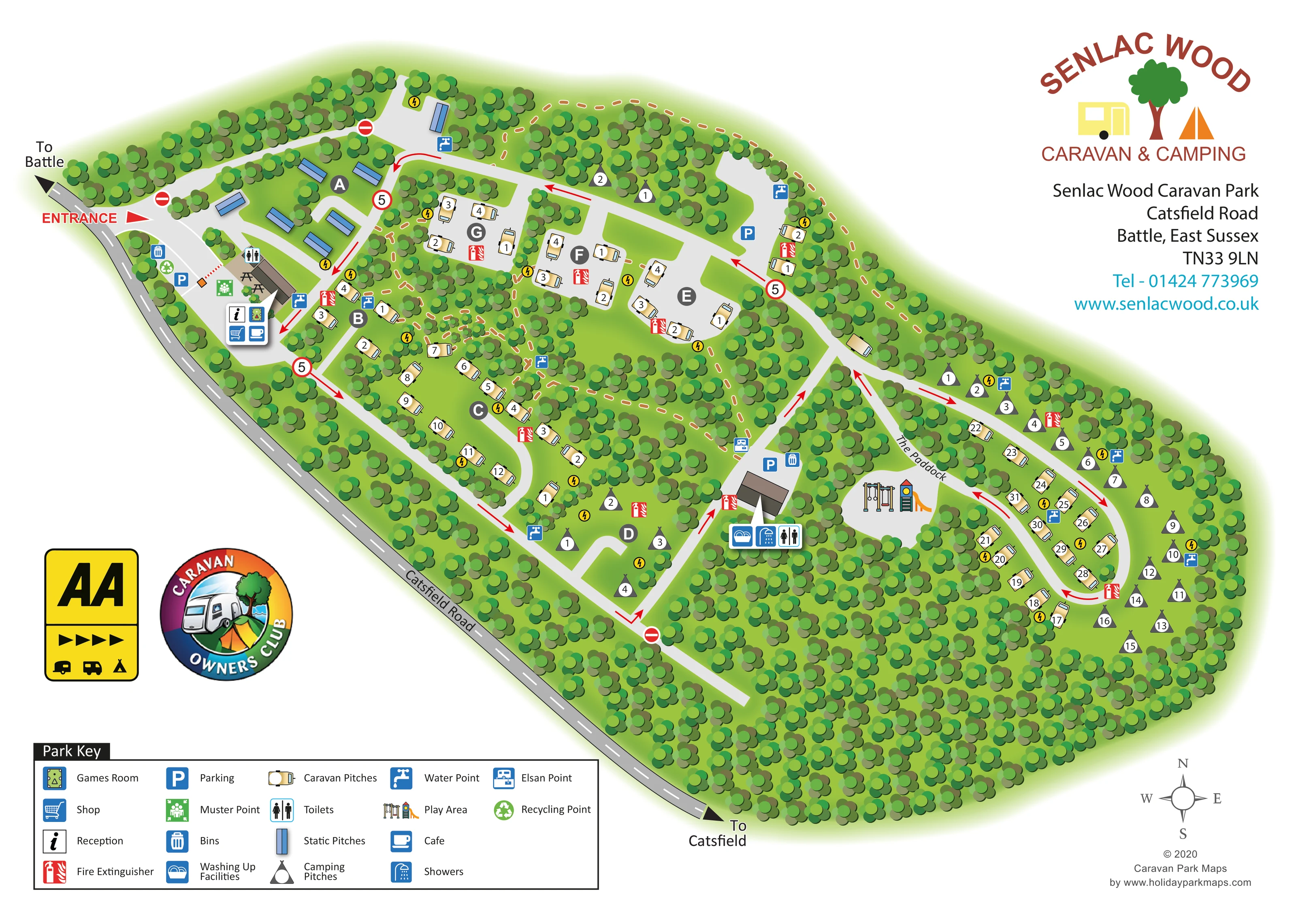
Dense tree symbols surround the park and divide accommodation into irregular clearings.
The named eastern section contains an elongated road loop, caravan pitches and camping pitches.
An information symbol marks reception within the entrance-side facilities cluster.
A shopping-trolley symbol appears beside reception near the entrance.
A cup symbol locates the café in the entrance-side cluster.
The games-room pictogram is grouped with reception, shop and café symbols.
Toilet symbols identify provision near the entrance and at the central amenities building.
A shower symbol marks the central amenities building beside the route towards The Paddock.
An information symbol marks reception within the entrance-side facilities cluster.
A shopping-trolley symbol appears beside reception near the entrance.
A cup symbol locates the café in the entrance-side cluster.
The games-room pictogram is grouped with reception, shop and café symbols.
Toilet symbols identify provision near the entrance and at the central amenities building.
A shower symbol marks the central amenities building beside the route towards The Paddock.
A washing-up symbol is grouped with showers and toilets at the central amenities building.
Illustrated swings and a slide occupy a clearing between the central facilities and The Paddock.
Blue tap symbols are distributed beside accommodation areas and access roads.
An Elsan disposal symbol appears beside the central approach to the amenities building.
Yellow lightning-bolt circles recur beside pitch groups. They are not explained in the printed key, but supplied park information confirms electric connections.
Blue P symbols mark parking near the entrance, on the upper road and beside the central amenities.
Bins are marked near the entrance and central amenities; a recycling symbol appears in the entrance area.
Red extinguisher symbols are distributed among the pitch groups and beside facilities.
A green muster-point symbol is shown near the entrance-side building.
Small picnic-table drawings sit beside the entrance-side building.
Dense tree symbols surround the park and divide accommodation into irregular clearings.
The named eastern section contains an elongated road loop, caravan pitches and camping pitches.
The entrance is marked at the upper-left end of the frontage on Catsfield Road, with external directions towards Battle and Catsfield.
Pale-grey roads link the pitch clearings. Red arrows, no-entry symbols and circular signs displaying 5 communicate circulation information.
Ochre dashed lines with pale edging thread through parts of the woodland and along the upper boundary; they are not named in the key.
READING THE MAP
This illustrated map of Senlac Wood Caravan Park places its woodland setting at the centre of the design. Near Battle in East Sussex, the park is shown as a series of green clearings connected by winding internal roads, with dense trees separating the accommodation areas and enclosing the site. Catsfield Road forms a clear diagonal boundary, and the entrance is easy to pick out at the Battle end of the frontage.
The map distinguishes touring caravan pitches, static pitches and camping pitches through separate symbols. Lettered areas A–G organise the western part of the park, while The Paddock forms a longer loop to the east. Reception, the shop, café and games room are grouped near arrival; another amenities building and the children's play area sit farther into the site.
A generous key, numbered pitches and brightly coloured service icons make the illustration useful for finding both accommodation and everyday facilities. The woodland remains visually prominent without obscuring the main roads, giving this sample a distinctive balance of landscape character and practical visitor information.
The single landscape-format artwork presents the park from above, stretching diagonally from the entrance at upper left to the rounded woodland boundary at lower right. A darker grey Catsfield Road follows the lower edge, with arrows towards Battle and Catsfield. Inside the park, pale-grey roads branch between clearings and connect to an elongated loop in The Paddock. Red arrows, no-entry symbols and signs displaying 5 add a separate layer of circulation information.
Accommodation is organised through both shape and labelling. Blue rectangular static-pitch symbols cluster in area A near the entrance. Cream caravan symbols occupy smaller clearings across the lettered areas and line the Paddock loop. Dark triangular camping symbols appear in several pockets, including area D and the eastern perimeter. White number discs identify pitches, while larger grey circles carry the area letters A–G.
The entrance-side facilities cluster includes reception, shop, café, games room and toilets, with nearby parking, recycling, bins, a muster point and picnic tables. Farther into the park, a second building is marked for washing up, showers and toilets. An Elsan point and additional parking sit nearby, and illustrated swings and a slide identify the play area between this central hub and The Paddock. Water points, fire extinguishers and yellow electrical symbols recur beside accommodation groups.
Overlapping tree crowns in lime, olive and darker greens create the woodland texture. Ochre dashed paths weave through parts of it. The boxed key fills the lower-left margin, while the park logo and contact details occupy the upper right. A compass, membership-style badges and designer credit complete the page. The enlarged details show portions of this same artwork rather than additional park sections.
KEEP EXPLORING
Chosen for shared landscapes, accommodation or facilities.
 Explore the map ↗
United Kingdom
Woodland-framed Barnsoul map with mixed accommodation, shared facilities and paw-marked walking routes.
 Explore the map ↗
United Kingdom
A colour-zoned coastal park map with touring areas, woodland trails, ponds and a leisure club.
 Explore the map ↗
United Kingdom
Colour-coded accommodation, lakeside facilities and woodland routes at Burton Constable Holiday Park & Arboretum.
Features may come from the sample artwork, its key or published park information. Approximate numbers describe the drawing and may cover only part of a park. They are intended to help you compare map examples. Current facilities and booking information should be checked with the park.
TAKE A CLOSER LOOK
View the illustrated map in detail or choose a file to download. These are sample maps; contact the park for current visitor information.

LET’S MAP YOUR PARK
For a map quotation, find your park and draw a rough boundary around it. The area you select helps us work out the design time and price.
Draw your park for a quote ↗Or talk to our map designers
01751 473136