
Tree-fringed ponds
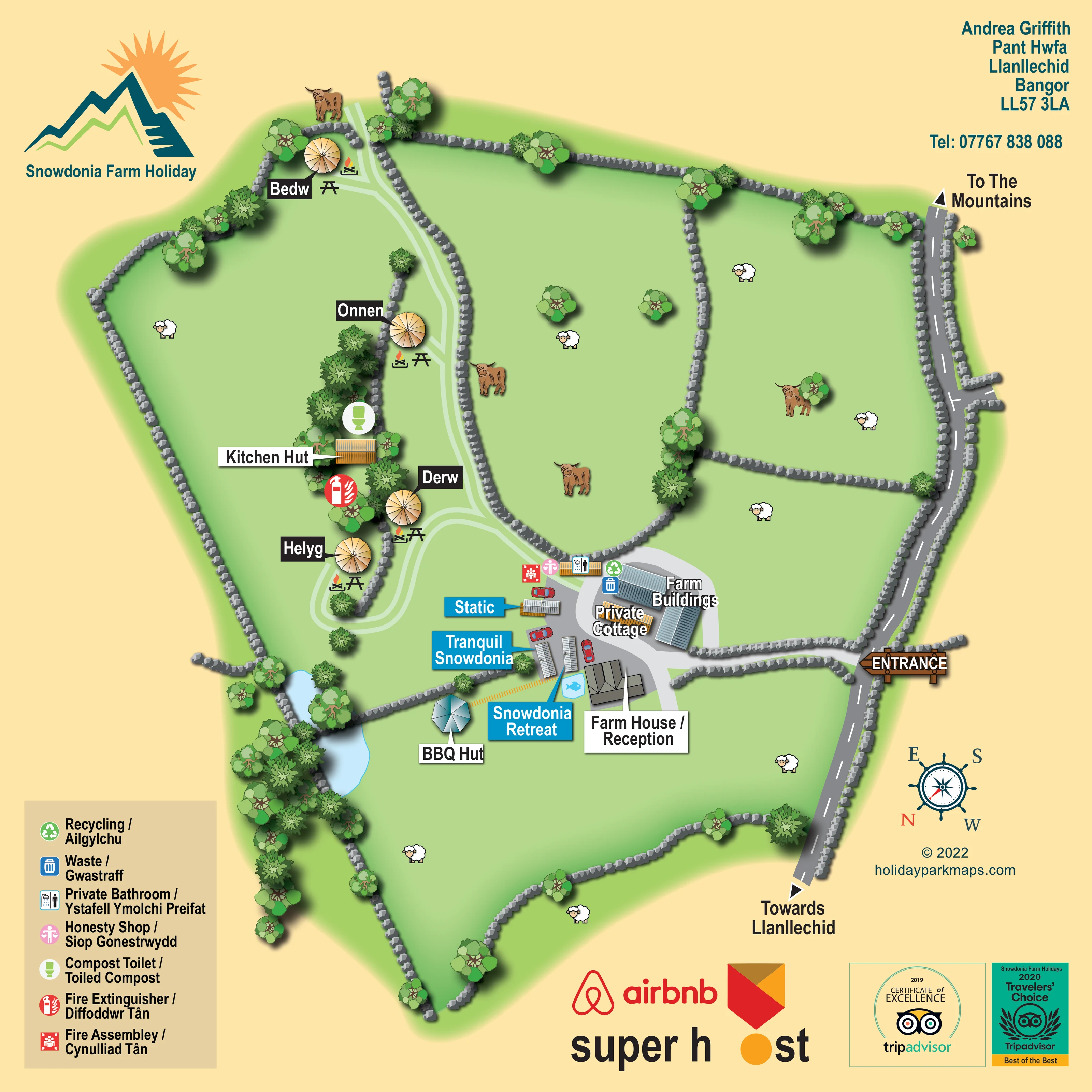
Pale blue pond shapes lie along the lower-left boundary near the BBQ hut, enclosed by trees and stone walls.
ILLUSTRATED PARK MAP · P307
Pant Hwfa, Llanllechid, Bangor · United Kingdom
 Enlarge the map ↗
A SENSE OF THE PLACE
Snowdonia Farm Holidays is based at Pant Hwfa, a farm at Llanllechid beneath the Carneddau mountains. Farmland, ponds and woodland provide the setting for holiday homes and yurt accommodation.
The yurts combine a sheltered woodland location with dedicated bathroom facilities and a kitchen hut. The map presents the accommodation within its wider farm setting, reflecting the site's emphasis on a rural break close to the mountains.
LOOK CLOSER
Pale blue pond shapes lie along the lower-left boundary near the BBQ hut, enclosed by trees and stone walls.
Dense illustrated trees shelter the yurt facilities and ponds, with lighter tree planting along field boundaries.
Irregular green fields are divided by prominent grey stone walls and illustrated with sheep and shaggy horned cattle.
The farmhouse at the lower side of the central yard is explicitly identified as reception.
Large grey-blue roofed buildings occupy the farmyard beside the entrance drive.
A building within the yard is labelled Private Cottage; it is not presented as visitor accommodation.
A small timber-coloured hut sits among trees beside the yurt path.
A distinctive polygonal hut stands below the holiday-home group, near the tree-fringed ponds.
The farmhouse at the lower side of the central yard is explicitly identified as reception.
Large grey-blue roofed buildings occupy the farmyard beside the entrance drive.
A building within the yard is labelled Private Cottage; it is not presented as visitor accommodation.
A small timber-coloured hut sits among trees beside the yurt path.
A distinctive polygonal hut stands below the holiday-home group, near the tree-fringed ponds.
The bilingual legend's private-bathroom symbol is placed on a small building at the upper edge of the farmyard.
A pink honesty-shop symbol marks the farmyard-side service area beside the bathroom building.
A green toilet symbol is positioned by the kitchen hut within the wooded yurt area.
Blue waste and green recycling symbols are grouped beside the main farm buildings.
A fire-extinguisher symbol appears near the kitchen hut, with a separate assembly-point symbol at the transition between the yurt path and farmyard.
Picnic-table and small fire symbols accompany each of the named yurts.
Pale blue pond shapes lie along the lower-left boundary near the BBQ hut, enclosed by trees and stone walls.
Dense illustrated trees shelter the yurt facilities and ponds, with lighter tree planting along field boundaries.
Irregular green fields are divided by prominent grey stone walls and illustrated with sheep and shaggy horned cattle.
A wooden entrance sign marks the right-hand lane junction; a light grey drive leads between stone walls into the farmyard.
Pale paths lead from the farmyard, loop around the lower yurts and continue up the tree-lined strip to Bedw.
The lane along the right edge has arrows labelled Towards Llanllechid at the lower end and To The Mountains at the upper end.
READING THE MAP
This illustrated map of Snowdonia Farm Holidays places a small collection of holiday homes and yurts within the much broader landscape of Pant Hwfa, a farm at Llanllechid near Bangor. Stone-walled fields, tree belts, ponds and farm animals give the artwork its rural character, while the accommodation and visitor facilities remain easy to pick out.
The composition centres on the farmyard and farmhouse reception, reached from the lane along the right-hand edge. Static-style holiday homes sit close to this arrival area, while four named yurts follow a pale path through a sheltered strip of trees. Their circular cream roofs contrast with the rectangular farm buildings and holiday homes, helping visitors recognise the different places at a glance.
Practical details include a kitchen hut, private bathroom facilities, an honesty shop, a compost toilet and a separate BBQ hut. An English/Welsh symbol key explains the service markers, and arrows point towards Llanllechid and the mountains. This sample is particularly relevant to small rural accommodation businesses that need to explain both their guest areas and the surrounding farm setting.
The single square map shows the farm as a series of irregular green enclosures bounded by individually illustrated grey stones. A dark lane runs down the right-hand side, with directions towards the mountains at one end and Llanllechid at the other. A wooden entrance sign marks the turn into a light grey drive, which leads between walls to the central farmyard.
The farmhouse/reception sits below the yard, with farm buildings and a clearly labelled private cottage above it. Three static-style accommodation illustrations form a small group to the left, identified by cyan callouts for Static, Tranquil Snowdonia and Snowdonia Retreat. Red cars help distinguish the developed arrival area from the surrounding fields.
Beyond the yard, pale paths branch and curve through the yurt area. Bedw occupies the upper end, Onnen sits further down, and Derw and Helyg flank the lower loop. Each yurt has a cream roof drawn in radial segments, a black name panel and nearby picnic-table and fire symbols. The kitchen hut is tucked into the trees, beside the compost-toilet and fire-extinguisher markers.
Private-bathroom, honesty-shop and fire-assembly symbols appear near the farmyard end of the path; waste and recycling markers sit by the farm buildings. Below the accommodation, a faceted BBQ hut stands near pale blue ponds and dense boundary planting.
The page balances the central illustration with a mountain-and-sun logo, contact block, bilingual facility key, decorative compass and award graphics. Soft shadows give walls, trees and roofs a raised appearance, while broad areas of pasture keep the plan readable. Sheep and cattle reinforce the farm identity without crowding the visitor routes.
KEEP EXPLORING
Chosen for shared landscapes, accommodation or facilities.
 Explore the map ↗
United Kingdom
Woodland-framed Barnsoul map with mixed accommodation, shared facilities and paw-marked walking routes.
 Explore the map ↗
United Kingdom
A colour-zoned coastal park map with touring areas, woodland trails, ponds and a leisure club.
 Explore the map ↗
United Kingdom
Woodland holiday-park map with named accommodation areas, touring loops and illustrated recreation facilities.
Features may come from the sample artwork, its key or published park information. Approximate numbers describe the drawing and may cover only part of a park. They are intended to help you compare map examples. Current facilities and booking information should be checked with the park.
LET’S MAP YOUR PARK
For a map quotation, find your park and draw a rough boundary around it. The area you select helps us work out the design time and price.
Draw your park for a quote ↗Or talk to our map designers
01751 473136