
Recreation field
A large eastern lawn separates the lakeside area from the pool and arrival facilities.
ILLUSTRATED PARK MAP · P323
Swiss Farm Touring & Camping, Marlow Road, Henley on Thames, Oxfordshire · United Kingdom
 Enlarge the map ↗
A SENSE OF THE PLACE
Swiss Farm offers touring, camping and glamping on the edge of Henley-on-Thames. Mature trees and hedgerows help define the landscaped pitches at this established family-run park.
Facilities include a seasonal heated outdoor swimming pool, children's play area, dog-walking field, cafe and shop. The map helps visitors find the different accommodation areas and shared amenities within the grounds.
LOOK CLOSER
A large eastern lawn separates the lakeside area from the pool and arrival facilities.
An irregular pale-blue lake sits within dense planting beside the glamping accommodation.
Dense mixed tree canopies frame the grounds, with smaller trees and hedges dividing accommodation rows.
Broad grassy spaces west of the pitches carry 'Dogs on Lead Please' labels and are linked by pale paths.
Information symbol marks the reception building beside the southern arrival courtyard.
Cutlery symbol identifies the café building near reception and the pool; The Farm Kitchen is named in the contact panel.
Labelled rectangular pool beside the café courtyard, illustrated with a swimmer and lifebuoy.
Picnic tables with striped parasols are drawn between the pool and café.
Information symbol marks the reception building beside the southern arrival courtyard.
Cutlery symbol identifies the café building near reception and the pool; The Farm Kitchen is named in the contact panel.
Labelled rectangular pool beside the café courtyard, illustrated with a swimmer and lifebuoy.
Picnic tables with striped parasols are drawn between the pool and café.
An outlined play enclosure contains swings, climbing equipment and a slide within the recreation field.
A large eastern lawn separates the lakeside area from the pool and arrival facilities.
An irregular pale-blue lake sits within dense planting beside the glamping accommodation.
A fishing-rod pictogram is placed on the lake; the artwork does not specify fishing arrangements.
Dense mixed tree canopies frame the grounds, with smaller trees and hedges dividing accommodation rows.
Broad grassy spaces west of the pitches carry 'Dogs on Lead Please' labels and are linked by pale paths.
Grouped callouts identify northern and southern washing facilities; the southern group includes the key's disabled-toilet symbol.
Pot-wash facilities are marked near both main washing groups, with laundry included in the southern callout.
Repeated blue tap symbols serve the tent field and touring rows.
Elsan symbols appear at the washing facilities and eastern pitch edge; a separate motorhome service symbol is shown near the southern accommodation group.
Green recycling symbols identify shared disposal points within the accommodation area.
A dog-wash illustration appears near the northern facilities, with dog-waste bins along western paths and near the southern arrival area.
Blue parking symbols and white bay markings identify parking around the arrival facilities, pool and lakeside.
Red fire-point symbols are distributed around the grounds, and a labelled fire assembly point appears near the entrance courtyard.
A green AED symbol is placed beside reception.
A timber-style entrance sign marks the southeastern access from Marlow Road, with arrows towards Marlow and Henley-on-Thames.
Light-grey roads form parallel accommodation lanes, short loops and an arrival courtyard; cream paths connect the western fields.
The arrival route includes a drawn barrier and 2 m height-limit symbol; repeated red-ringed 5 markers appear on internal roads.
The artwork places no-dog symbols at the pool and play area, alongside lead-request labels in the western grass fields.
A shop is mentioned in the park context but is not separately identified on the illustrated plan.
READING THE MAP
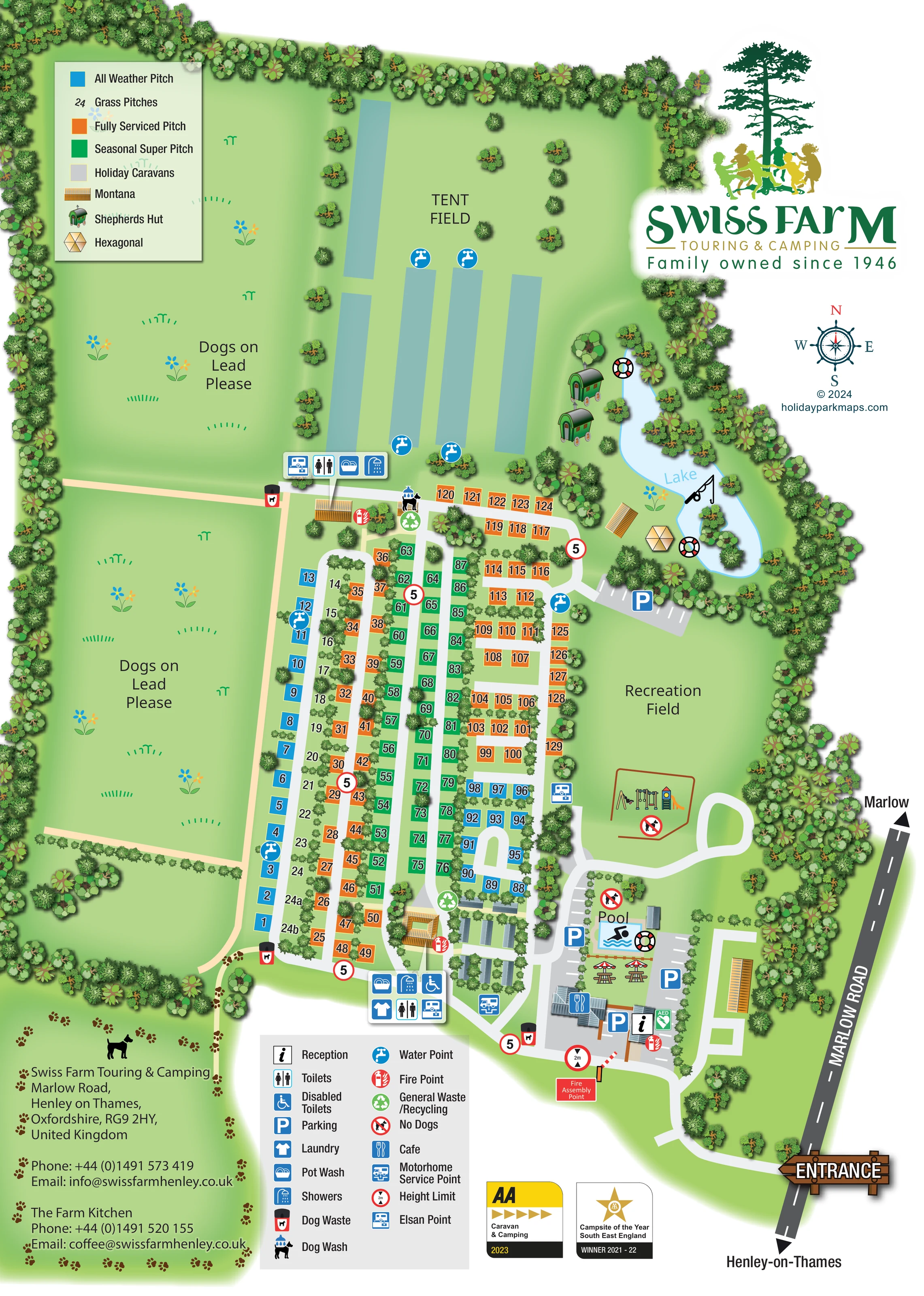
This illustrated map of Swiss Farm Touring & Camping brings together landscaped touring pitches, a spacious tent field and a small lakeside glamping area on the edge of Henley-on-Thames, Oxfordshire. Mature trees form a distinctive green frame around the grounds, while hedges and smaller planting groups help explain how the accommodation is divided.
The plan follows the visitor's arrival from Marlow Road into the reception and café courtyard, then opens out into numbered pitch rows, shared facilities and recreation spaces. Blue, orange and green pitch colours distinguish all-weather, fully serviced and seasonal provision, with grass pitches and holiday caravans also explained in the accommodation key. Beside the lake, illustrated shepherds huts and other glamping units give this quieter corner its own visual identity.
Practical symbols identify washing facilities, water points, parking and touring services. The pool, children's play equipment and broad recreation field are equally easy to pick out. A large Swiss Farm logo, compass, timber-style entrance sign and separate service legend complete a portrait layout designed for both an initial overview and everyday pitch-finding.
The map is arranged as a tall, tree-edged plan with its entrance at the lower right. Marlow Road runs diagonally along the eastern boundary, with arrows naming Marlow and Henley-on-Thames. Inside the entrance, a curved drive reaches the reception building, café, parking and outdoor pool. Picnic tables with parasols sit between the café and pool, and a green AED marker appears beside reception.
The main touring area occupies the centre and lower half of the grounds. Parallel lanes, short cross-connections and compact loops organise the numbered pitches into recognisable blocks. All-weather pitches are blue, fully serviced pitches orange and seasonal super pitches green; grass pitches are indicated by numbers on the lawn. Small trees and hedges separate many of the rows. A compact holiday-caravan group lies near the southern washing facilities.
To the north, the labelled tent field contains long blue-green strips and several water points rather than individually numbered tent spaces. Its southern edge has a grouped callout for toilets, showers, pot wash and an Elsan point. Another callout beside the southern facilities includes laundry and accessible toilets. Recycling, fire points, dog-waste bins and a dog wash are marked around the accommodation areas.
The eastern side provides a contrasting sequence of open recreation lawn, illustrated play equipment and a curving lake. Two shepherds huts, a Montana unit and a hexagonal glamping unit appear beside the water, which also carries an angling pictogram. Cream paths connect the western grass fields, where lead-request labels are prominent.
This single portrait artwork uses an accommodation key at the upper left and a service legend below the plan. The enlarged quadrant views show details of the same composition, not additional park sections.
KEEP EXPLORING
Chosen for shared landscapes, accommodation or facilities.
 Explore the map ↗
United Kingdom
Colour-coded accommodation, lakeside facilities and woodland routes at Burton Constable Holiday Park & Arboretum.
 Explore the map ↗
United Kingdom
Woodland holiday homes, named camping fields and farm buildings on a colour-coded Nether Wasdale park map.
 Explore the map ↗
United Kingdom
Illustrated caravan park plan with woodland and riverside walks, fishing pools and wildlife panels.
Features may come from the sample artwork, its key or published park information. Approximate numbers describe the drawing and may cover only part of a park. They are intended to help you compare map examples. Current facilities and booking information should be checked with the park.
LET’S MAP YOUR PARK
For a map quotation, find your park and draw a rough boundary around it. The area you select helps us work out the design time and price.
Draw your park for a quote ↗Or talk to our map designers
01751 473136