
Tree-lined grounds
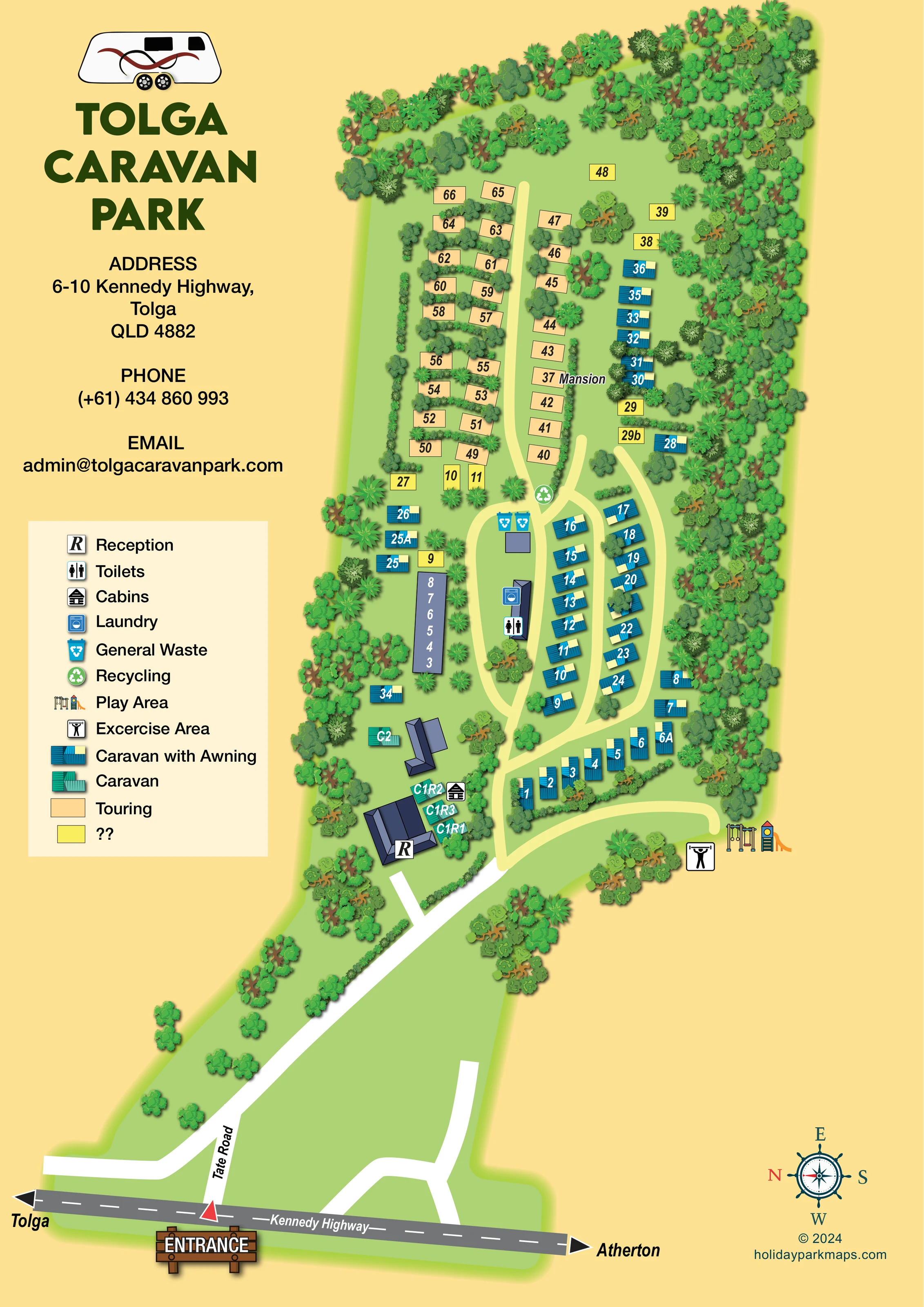
Dense illustrated tree cover frames the upper and right boundaries, with varied broadleaf and palm-like forms between accommodation rows.
ILLUSTRATED PARK MAP · P342
6–10 Kennedy Highway, Tolga, Queensland · Australia
 Enlarge the map ↗
A SENSE OF THE PLACE
Tolga Caravan Park provides a base on the Atherton Tablelands in Queensland. Shady camping and caravan sites sit alongside self-contained cabins.
Powered and unpowered options cater for different camping setups, with slab and grass pitches available for vans and motorhomes. The park welcomes pets and offers access to Tolga, Atherton and the Tablelands' natural attractions.
LOOK CLOSER
Dense illustrated tree cover frames the upper and right boundaries, with varied broadleaf and palm-like forms between accommodation rows.
Small trees and hedge-like planting divide touring pitches and line parts of the arrival drive and caravan rows.
An R marker identifies the large dark-roofed building beside the arrival drive, close to the cabin cluster.
A toilet pictogram marks the central amenities building within the lower internal loop.
A blue washing-machine symbol identifies laundry facilities at the same central amenities building.
Two blue waste-bin symbols are grouped near the junction between the central loop and the upper accommodation lane.
A green recycling symbol appears just above the waste-bin group beside an internal route.
Swings and a brightly coloured climbing tower with slide mark a play area at the lower-right edge of the main park.
An R marker identifies the large dark-roofed building beside the arrival drive, close to the cabin cluster.
A toilet pictogram marks the central amenities building within the lower internal loop.
A blue washing-machine symbol identifies laundry facilities at the same central amenities building.
Two blue waste-bin symbols are grouped near the junction between the central loop and the upper accommodation lane.
A green recycling symbol appears just above the waste-bin group beside an internal route.
Swings and a brightly coloured climbing tower with slide mark a play area at the lower-right edge of the main park.
An exercise pictogram sits beside the play area, reached by a short curved branch of the internal route.
Dense illustrated tree cover frames the upper and right boundaries, with varied broadleaf and palm-like forms between accommodation rows.
Small trees and hedge-like planting divide touring pitches and line parts of the arrival drive and caravan rows.
A timber-style ENTRANCE sign and red triangular pointer mark the highway junction with Tate Road.
The white diagonal approach road is labelled Tate Road and leads from Kennedy Highway towards reception.
Opposing arrows along Kennedy Highway identify Tolga to the left and Atherton to the right of the page.
Pale-yellow routes form linked loops through the caravan area, a long lane through the touring rows and a short branch towards recreation facilities.
The name Mansion appears beside a peach touring rectangle in the upper-middle section. Its function is not explained, so it should be treated as a local map label rather than a confirmed amenity.
READING THE MAP
This illustrated map of Tolga Caravan Park presents a tree-lined caravan and camping base on Queensland’s Atherton Tablelands. Its tall page format follows the site from Kennedy Highway and Tate Road into the accommodation area, giving the arrival route almost as much visual importance as the pitches themselves. A large caravan logo, stacked park name and practical information column balance the detailed plan on the right.
The map shows rows of blue caravan illustrations, peach-coloured touring pitches and a small cabin-labelled cluster beside reception. Dense green planting frames the grounds and separates many of the accommodation positions, conveying the shady character of the park without obscuring its main circulation pattern. Toilets, laundry, waste and recycling are marked around the central routes, while a play area and exercise area occupy the lower-right edge.
For visitors, the combination of numbered positions, recognisable symbols and a prominent entrance marker supports orientation from the highway to the individual accommodation rows. For a map-design gallery, it is a distinctive example of a compact park plan with an extended roadside approach and strongly illustrated vegetation.
The single portrait map combines the park plan with its immediate road approach. Kennedy Highway runs across the bottom, with arrows towards Tolga and Atherton. A timber-style entrance sign and red pointer highlight the junction with Tate Road, which continues diagonally towards reception. The compass places north to the left, so the composition should be read through its road names and orientation symbol rather than assuming a conventional north-up layout.
Reception occupies a substantial dark-roofed building near the lower-left corner of the main accommodation area. A nearby cabin symbol identifies a small group of room-labelled units. From this arrival point, pale-yellow internal routes spread into linked loops around rows of blue caravans with cream awning sections. A central building carries both toilet and laundry symbols, and waste and recycling markers sit farther along the route towards the upper pitches.
The upper part of the park has a different rhythm: peach touring rectangles line a long lane, with hedges and trees dividing the rows. More caravan symbols sit towards the densely planted right-hand boundary. Yellow numbered rectangles and a purple numbered strip are also present, although their categories are not fully explained by the legend. The local label Mansion appears beside one touring position.
A short curved route leads towards the illustrated swings, slide and exercise marker at the lower-right edge. Throughout the plan, layered tree canopies, palm-like forms and soft shadows contrast with the simple pitch shapes and clear route lines. The left-hand legend brings facility icons and accommodation symbols together beneath the park’s branding and contact panel. The accompanying detail views enlarge overlapping portions of this same artwork rather than showing separate park sections or additional maps.
KEEP EXPLORING
Chosen for shared landscapes, accommodation or facilities.
 Explore the map ↗
United Kingdom
A wooded Allerton park plan with colour-coded neighbourhoods, touring pitches and a central facilities hub.
 Explore the map ↗
United Kingdom
Colour-coded accommodation, central leisure facilities and coastal paths on an illustrated headland park map.
 Explore the map ↗
United States
Colour-coded RV pitches, woodland borders and two activity hubs at Camp '89 Grand Haven.
Features may come from the sample artwork, its key or published park information. Approximate numbers describe the drawing and may cover only part of a park. They are intended to help you compare map examples. Current facilities and booking information should be checked with the park.
LET’S MAP YOUR PARK
For a map quotation, find your park and draw a rough boundary around it. The area you select helps us work out the design time and price.
Draw your park for a quote ↗Or talk to our map designers
01751 473136