
Wildings Lake
A long, pale-blue lake forms the eastern edge of the campsite depiction, with trees and shrubs along both banks.
ILLUSTRATED PARK MAP · P343
Cinder Hill, Chailey, Lewes · United Kingdom
 Enlarge the map ↗
A SENSE OF THE PLACE
Tomkins Farm is based at Cinder Hill, Chailey, Lewes. Grass camping pitches and ready-erected bell tents are advertised.
Pitches have firepits, with toilets, hot showers and washing-up facilities nearby. Camels Humps is described as serving weekend breakfasts, pizzas and drinks with a licensed bar. The operator describes allocating a specific area to large groups.
LOOK CLOSER
A long, pale-blue lake forms the eastern edge of the campsite depiction, with trees and shrubs along both banks.
Dense tree clusters border the western service area and southern play area, while a narrower belt follows the lake. The walking map shows wider woodland blocks.
Brown post-and-rail-style boundaries define the camping fields and neighbouring green pasture, decorated with small sheep illustrations.
The lower field includes full-sun and morning-shade annotations, plus a note that pitches beside the farm drive can be dusty.
The walking sheet names woodland including Wilding Wood and Markstakes Common, alongside farms, St Peter's Church, ponds and streams. The A275, Cinder Hill and Markstakes Lane provide road context.
Labelled beside the farm drive on the western side of the camping fields, with a matching pictogram.
Located in the same compact roadside service cluster as the toilets and washing-up facilities.
A labelled washing-up point completes the service cluster between the two field entrances.
Labelled beside the farm drive on the western side of the camping fields, with a matching pictogram.
Located in the same compact roadside service cluster as the toilets and washing-up facilities.
A labelled washing-up point completes the service cluster between the two field entrances.
Brown general-waste and green recycling symbols are positioned beside the upper field entrance and explained in the legend.
Named within the densely illustrated woodland at the southern edge of the lower camping field; individual play equipment is not specified.
A larger-groups pitch is labelled near the lake-facing side of the lower field.
A long, pale-blue lake forms the eastern edge of the campsite depiction, with trees and shrubs along both banks.
Dense tree clusters border the western service area and southern play area, while a narrower belt follows the lake. The walking map shows wider woodland blocks.
Brown post-and-rail-style boundaries define the camping fields and neighbouring green pasture, decorated with small sheep illustrations.
The lower field includes full-sun and morning-shade annotations, plus a note that pitches beside the farm drive can be dusty.
Wooden entrance signs distinguish the lower and upper pitch groups. Gates connect each field to the white farm drive.
A broad white drive curves beneath the wooded southern boundary and runs up the western edge. A pale twin-line track curves into the upper field.
The separate walking map overlays a conspicuous pink dashed network across countryside, woods and local roads, with a black 'You Are Here' callout.
A westward arrow points towards Five Bells and the Chailey Loop Walk, annotated '10 mins to Pub'.
A northward route annotation points towards Newick village and pubs, with a mapped walking-time label of 40 minutes.
An eastward arrow identifies the onward route towards Anchor Pub and Barcombe Mills, annotated '1.45hrs'.
The walking sheet names woodland including Wilding Wood and Markstakes Common, alongside farms, St Peter's Church, ponds and streams. The A275, Cinder Hill and Markstakes Lane provide road context.
The operator information describes firepits at pitches; they are not separately marked on the campsite plan.
The park information describes weekend breakfasts, pizzas, drinks and a licensed bar at Camels Humps. This venue is not labelled on either map.
READING THE MAP
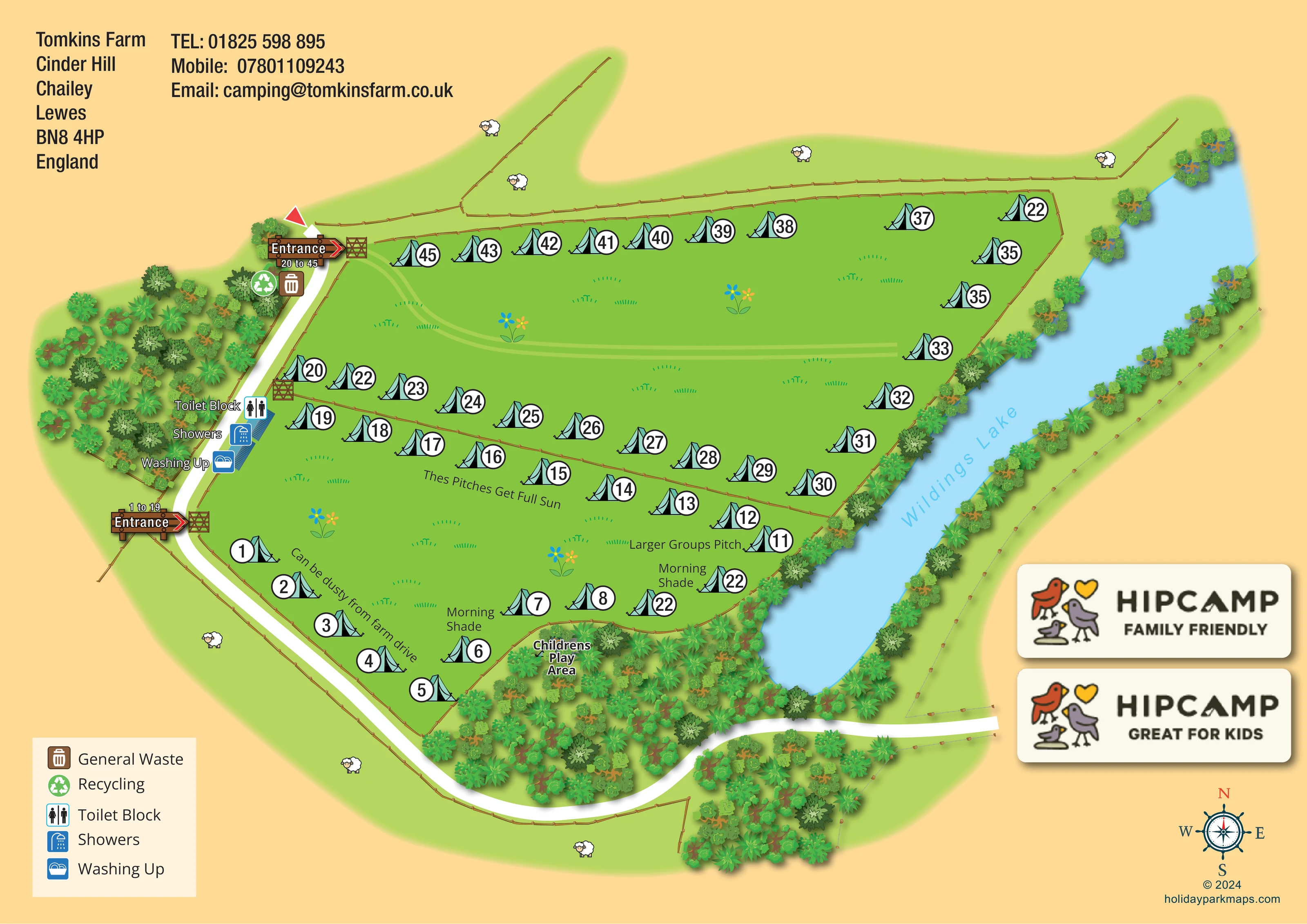
These two maps for Tomkins Farm at Cinder Hill, Chailey, near Lewes combine campsite orientation with ideas for exploring the surrounding countryside. The illustrated site plan places two grass camping fields beside Wildings Lake, with woodland, fences and a curving farm drive giving the layout its distinctive shape. Turquoise tent symbols and bold circular pitch numbers make the camping areas easy to recognise without filling the open field centres with unnecessary detail.
Practical information is woven into the drawing. Separate entrance signs identify the two pitch groups, while toilets, showers and washing-up facilities form a clearly labelled cluster beside the drive. The map also marks recycling, general waste, a children's play area and a larger-groups pitch. Notes about morning shade, full sun and possible dust from the farm drive add useful local character.
The companion walking map changes scale and visual language. Pink dashed routes stand out against a pale countryside base, with arrows towards Five Bells, Newick village and the route to Anchor Pub and Barcombe Mills. Together, the sheets address both finding a pitch and understanding what lies beyond the campsite.
The campsite sheet is built around two fenced green fields, separated by a diagonal boundary and bordered by Wildings Lake on the right. Numbered turquoise tents follow the field edges and the dividing fence, leaving generous open centres. A broad white farm drive sweeps beneath the wooded southern edge, then rises along the left side of the plan. Wooden entrance signs and illustrated gates distinguish access to the lower and upper pitch groups.
Between those entrances, a compact service area carries separate labels and pictograms for the toilet block, showers and washing up. Waste and recycling symbols sit beside the upper entrance. The lower field includes a larger-groups pitch, morning-shade labels near the trees and a full-sun annotation across another pitch row. A diagonal note identifies possible dust from the adjoining farm drive. The children's play area is named within the southern woodland rather than represented by individual pieces of equipment.
The drawing uses a warm ochre page background, vivid grass, pale-blue water and layered green tree canopies. Grass tufts, flowers and sheep provide a farm setting without competing with the large pitch numbers. A five-item legend anchors the lower left; contact details sit above it, while Hipcamp badges and a compass balance the right-hand side.
The separate walking sheet uses flat geographical mapping. Yellow roads, pale-green woodland, blue waterways and small building footprints sit beneath a bold pink dashed route network. A black 'You Are Here' box provides orientation, and three destination arrows identify Five Bells and the Chailey Loop Walk, Newick village and pubs, and Anchor Pub with Barcombe Mills. Walking-time labels give these onward directions additional context. Named farms, woodland and local roads help connect the campsite with the wider rural landscape.
KEEP EXPLORING
Chosen for shared landscapes, accommodation or facilities.
 Explore the map ↗
United Kingdom
Woodland park map with mixed pitches, bell tents, lodges and a fishing lake.
 Explore the map ↗
United Kingdom
Colour-coded accommodation, lakeside facilities and woodland routes at Burton Constable Holiday Park & Arboretum.
 Explore the map ↗
United Kingdom
Woodland holiday homes, named camping fields and farm buildings on a colour-coded Nether Wasdale park map.
Features may come from the sample artwork, its key or published park information. Approximate numbers describe the drawing and may cover only part of a park. They are intended to help you compare map examples. Current facilities and booking information should be checked with the park.
LET’S MAP YOUR PARK
For a map quotation, find your park and draw a rough boundary around it. The area you select helps us work out the design time and price.
Draw your park for a quote ↗Or talk to our map designers
01751 473136