
Ullswater
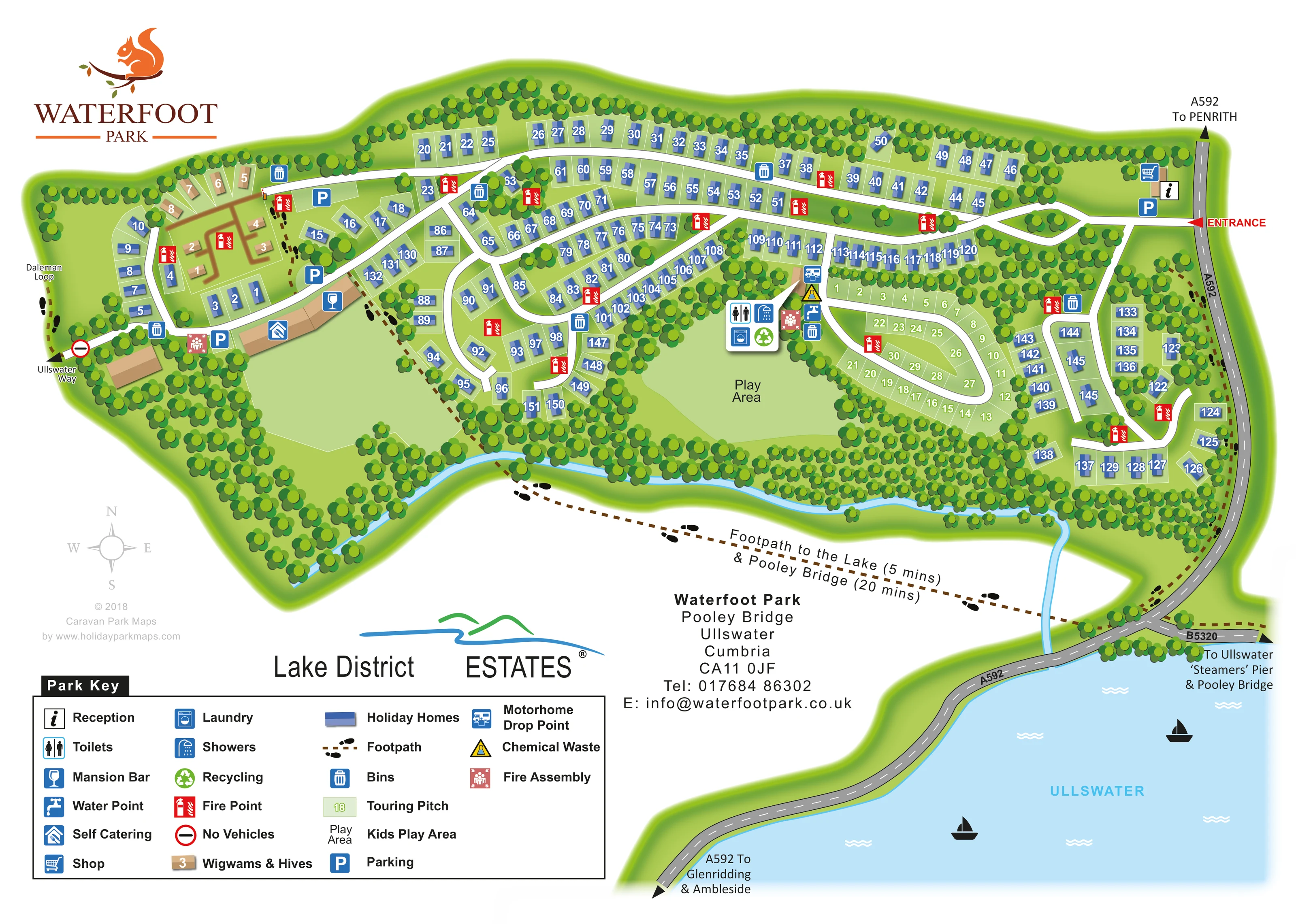
A large pale-blue lake area anchors the lower-right corner, separated from the park by the surrounding road and landscape.
ILLUSTRATED PARK MAP · P637
Waterfoot Park, Pooley Bridge, Ullswater, Cumbria · United Kingdom
 Enlarge the map ↗
A SENSE OF THE PLACE
Waterfoot Park is located near Pooley Bridge and Ullswater in the Lake District. Glamping pods, S-Pods, self-catering properties and holiday homes sit within a landscape of surrounding fells.
Dog-friendly accommodation is available, and shared facilities include the Mansion House lounge and electric vehicle charging. Walking, cycling and time on Ullswater offer ways to explore beyond the park.
LOOK CLOSER
A large pale-blue lake area anchors the lower-right corner, separated from the park by the surrounding road and landscape.
Dense stylised trees enclose the boundary, divide accommodation groups and frame the open green spaces.
A narrow blue watercourse follows much of the southern park edge before continuing towards Ullswater.
An unlabelled open lawn occupies the south-western interior, separate from the labelled play area.
Information symbol beside the main eastern entrance, close to the shop and parking.
Shopping-trolley symbol marks a small building near the entrance.
Wine-glass symbol identifies the bar within the western building group.
A clearly marked shared-facility cluster sits immediately west of the touring loop and above the play area.
Information symbol beside the main eastern entrance, close to the shop and parking.
Shopping-trolley symbol marks a small building near the entrance.
Wine-glass symbol identifies the bar within the western building group.
A clearly marked shared-facility cluster sits immediately west of the touring loop and above the play area.
Tap symbols identify water provision beside the touring service cluster.
A dedicated motorhome service symbol appears on the approach to the touring area.
Yellow triangular symbol marks chemical waste disposal alongside the touring facilities.
Blue bin symbols recur around the accommodation roads; a green recycling symbol appears at the central service cluster.
Red fire-point symbols are distributed throughout the park, with separate pink assembly symbols near the western buildings and touring facilities.
A broad green space below the central facilities is explicitly labelled Play Area.
Blue P symbols mark parking at the eastern entrance and around the western buildings and glamping area.
A red entrance arrow connects the eastern access road to the A592. Direction labels point towards Penrith, Glenridding and Ambleside; the B5320 is also named.
A brown dashed route with footprint symbols leads south-east from the park. The artwork labels the lake as five minutes away and Pooley Bridge as twenty minutes away.
Named walking-route connections appear at the western boundary, with additional dashed footpaths through and around the park.
A red-ringed no-vehicles symbol marks the western walking-route connection.
An external road-direction label points towards the pier and Pooley Bridge; the pier itself is not depicted within the park.
A large pale-blue lake area anchors the lower-right corner, separated from the park by the surrounding road and landscape.
Dense stylised trees enclose the boundary, divide accommodation groups and frame the open green spaces.
A narrow blue watercourse follows much of the southern park edge before continuing towards Ullswater.
An unlabelled open lawn occupies the south-western interior, separate from the labelled play area.
Published park information mentions a shared Mansion House lounge; the map specifically labels the Mansion Bar rather than a lounge.
Mentioned in published park information, but not identified on this artwork.
READING THE MAP
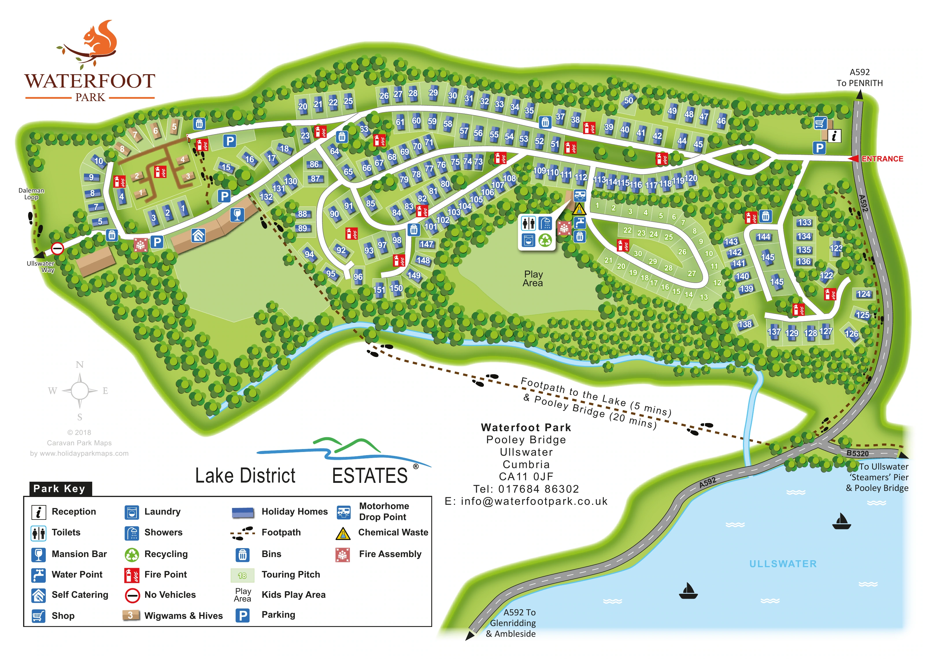
This illustrated map of Waterfoot Park places a substantial holiday-home site within its wooded setting near Pooley Bridge and Ullswater in Cumbria. The park stretches across the upper part of the page, while the lake and surrounding roads give visitors a clear sense of its wider Lake District location. Dense bands of stylised trees frame the accommodation, open lawns and winding internal roads without obscuring the practical information.
The design distinguishes blue holiday homes, pale-green touring pitches and a small tan group of Wigwams & Hives. Reception and the shop sit beside the eastern entrance, while the Mansion Bar and self-catering buildings are shown towards the west. A central cluster of touring facilities is easy to recognise beside the play area.
Walking connections are an important part of the composition. Dashed brown paths and footprint symbols lead towards the lake, Pooley Bridge, Ullswater Way and Daleman Loop. Together with the large key and numbered accommodation, these details make the sample useful for parks that need to explain both their internal layout and the attractions beyond their boundary.
The plan is organised around an eastern entrance from the A592, marked with a red arrow beside reception, the shop and parking. From here, white internal roads extend across the park and branch into curving loops. Blue holiday-home symbols follow these roads in long northern bands, tighter central groups and a separate eastern pocket. Their orientation follows the individual plots, giving the layout more character than a uniform grid.
At the western end, tan numbered Wigwams & Hives form a distinct accommodation group near parking and the named walking-route connections. Larger tan buildings below them carry the self-catering and Mansion Bar symbols. An open lawn occupies much of the south-western interior, edged by trees and a footpath.
The touring area is a compact pale-green loop in the centre-right of the plan. Immediately beside it, grouped symbols identify toilets, showers, laundry, recycling, water, chemical waste disposal and a motorhome drop point. The labelled play area lies just below this service cluster. Bins and red fire-point markers recur around the wider site, with separate assembly-point symbols included in the key and plan.
Landscape and external routes complete the picture. A narrow blue watercourse follows the southern tree belt, while a dashed walking route heads towards the lake and Pooley Bridge. The A592 curves through the lower-right composition beside a broad depiction of Ullswater, with further directions towards the 'Steamers' Pier, Penrith, Glenridding and Ambleside.
This is a single-page design: the enlarged detail views show its existing key and lake context, not additional map variants. The lower page balances a four-column legend, estate branding and contact information against the water illustration, leaving the main accommodation plan visually dominant.
KEEP EXPLORING
Chosen for shared landscapes, accommodation or facilities.
 Explore the map ↗
United Kingdom
Woodland holiday homes, named camping fields and farm buildings on a colour-coded Nether Wasdale park map.
 Explore the map ↗
United Kingdom
Illustrated caravan park plan with woodland and riverside walks, fishing pools and wildlife panels.
 Explore the map ↗
United Kingdom
Woodland park map with mixed pitches, bell tents, lodges and a fishing lake.
Features may come from the sample artwork, its key or published park information. Approximate numbers describe the drawing and may cover only part of a park. They are intended to help you compare map examples. Current facilities and booking information should be checked with the park.
TAKE A CLOSER LOOK
View the illustrated map in detail or choose a file to download. These are sample maps; contact the park for current visitor information.


LET’S MAP YOUR PARK
For a map quotation, find your park and draw a rough boundary around it. The area you select helps us work out the design time and price.
Draw your park for a quote ↗Or talk to our map designers
01751 473136
 waterfoot_large.png