
Pond
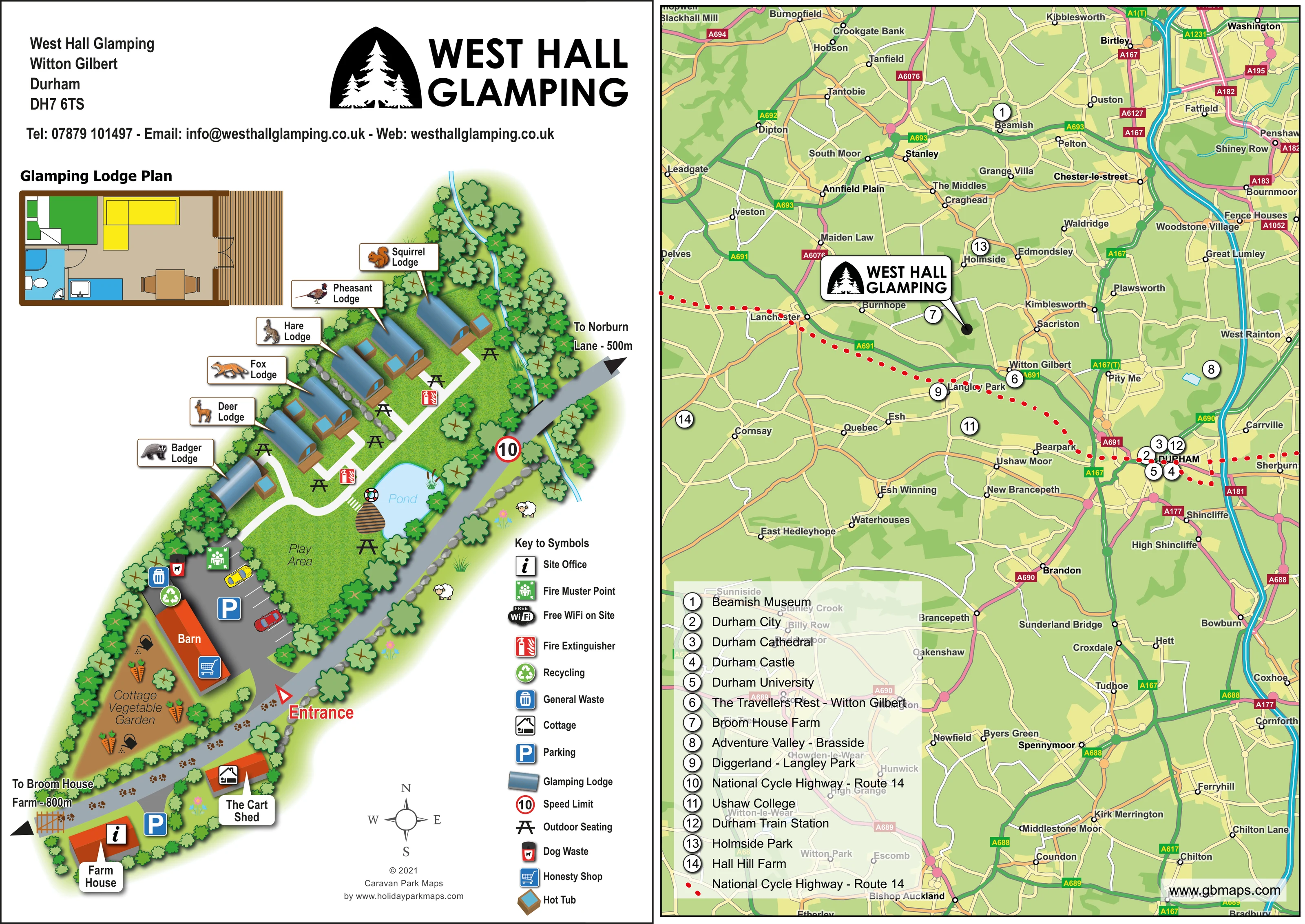
A small blue pond has reeds, a timber platform and a lifebuoy illustration.
ILLUSTRATED PARK MAP · P641
West Hall Glamping, Witton Gilbert, Durham · United Kingdom
 Enlarge the map ↗
A SENSE OF THE PLACE
West Hall Glamping is a family-run site at Witton Gilbert near Durham. Individual glamping pods provide a countryside retreat within reach of the city and the wider North East.
The pods have private hot tubs, kitchens and outdoor areas with fire-bowl and barbecue facilities. Dog-friendly stays are available, and the map shows how the accommodation is arranged across the grounds.
LOOK CLOSER
A small blue pond has reeds, a timber platform and a lifebuoy illustration.
A brown cultivated area beside the barn is labelled Cottage Vegetable Garden and illustrated with vegetables and gardening motifs.
Dense illustrated trees frame the lodges and garden; grey stones edge parts of the road and accommodation area.
A slim blue watercourse winds through the trees near the upper lodges and continues beside the approach road.
Small square, blue-filled hot tubs are illustrated beside the glamping lodges.
Picnic-table symbols appear throughout the lodge grounds and beside the pond.
A grassy area between the pond and arrival parking is labelled Play Area; individual play equipment is not illustrated.
The information symbol is positioned on the farmhouse near the lower end of the approach.
Small square, blue-filled hot tubs are illustrated beside the glamping lodges.
Picnic-table symbols appear throughout the lodge grounds and beside the pond.
A grassy area between the pond and arrival parking is labelled Play Area; individual play equipment is not illustrated.
A small blue pond has reeds, a timber platform and a lifebuoy illustration.
The information symbol is positioned on the farmhouse near the lower end of the approach.
A shopping-trolley symbol identifies the honesty shop at the barn.
A long, orange-roofed barn forms one edge of the main parking area.
A brown cultivated area beside the barn is labelled Cottage Vegetable Garden and illustrated with vegetables and gardening motifs.
Parking symbols mark the main arrival court beside the barn and a smaller area near the farmhouse.
Grouped waste, recycling and dog-waste symbols appear at the edge of the main parking area.
Extinguisher symbols are distributed along the lodge paths, with a fire muster point beside the parking area.
The key states Free WiFi on Site; no separate location is identified on the plan.
A red arrow and prominent Entrance label identify the turn into the parking court from the diagonal approach road.
White paths lead from the arrival area, curve around the pond and branch towards individual lodge decks.
A red-ringed 10 sign appears on the approach road and is identified as a speed-limit symbol in the key.
Opposing road-end arrows read To Norburn Lane – 500m and To Broom House Farm – 800m.
Dense illustrated trees frame the lodges and garden; grey stones edge parts of the road and accommodation area.
A slim blue watercourse winds through the trees near the upper lodges and continues beside the approach road.
A separate top-down inset illustrates sleeping, seating, dining, kitchenette and bathroom areas, together with an exterior deck.
A second panel places the park among Durham-area roads and settlements, using a branded pointer and numbered destination markers.
The regional map uses a red dotted line labelled National Cycle Highway – Route 14.
The numbered regional key includes Beamish Museum, Durham City, Durham Cathedral, Durham Castle, Durham University, The Travellers Rest at Witton Gilbert, Broom House Farm, Adventure Valley at Brasside, Diggerland at Langley Park, Ushaw College, Durham Train Station, Holmside Park and Hall Hill Farm.
Published park information describes private hot tubs, kitchens and outdoor areas with fire-bowl and barbecue facilities. The floor-plan inset supports the kitchen provision, but fire bowls and barbecues are not separately identified on the site plan.
READING THE MAP
This West Hall Glamping map brings a small countryside retreat at Witton Gilbert, near Durham, together with a guide to the surrounding area. The page pairs a characterful illustrated site plan with a regional road map, helping guests understand both the accommodation grounds and the places they might explore during their stay.
The site illustration follows a narrow, tree-lined layout, with animal-named glamping lodges arranged above the arrival area. Curved roofs, timber decks and individual hot tubs make the accommodation easy to recognise, while animal pictures distinguish the lodge labels. White paths connect the units with a pond, outdoor seating and a grassy play area. Below them, the barn, farmhouse, parking and vegetable garden give the drawing a distinctly rural character.
A separate lodge floor plan explains the interior arrangement, and the symbol key identifies practical features such as the office, honesty shop and waste points. On the right, a branded locator and numbered destinations connect the park with Durham, nearby attractions and Route 14. The result is a combined arrival, accommodation and local-orientation map rather than a site plan alone.
The artwork is organised as two bordered panels. On the left, West Hall Glamping branding and contact details sit above a lodge floor-plan inset and an oblique illustration of the grounds. The site stretches diagonally across the page, with a grey approach road along one side and dense trees defining much of its perimeter. A red entrance arrow directs attention to the parking court beside the barn; the farmhouse and separately labelled Cart Shed sit farther down the approach.
The upper section contains around half a dozen glamping lodges. Badger, Deer, Fox, Hare, Pheasant and Squirrel labels use animal illustrations and leader lines to identify the accommodation. Blue-grey curved roofs, timber decks and square hot tubs give each unit a consistent visual form. A white pedestrian path branches towards the lodges and curves around the pond, with picnic-table symbols placed nearby. The pond is illustrated with reeds, a timber platform and a lifebuoy, while a neighbouring lawn is labelled Play Area.
Practical information is integrated through symbols: the farmhouse carries the site-office marker, the barn has the honesty-shop marker, and the arrival area includes parking, waste, recycling, dog-waste and fire-muster symbols. Extinguisher markers appear along the lodge paths. A vegetable garden, stone edging and a narrow watercourse add setting and orientation. The inset shows the lodge's sleeping, seating, dining, kitchen and bathroom arrangement.
The right-hand panel changes to conventional regional cartography, with colour-coded roads, settlement labels, a branded park pointer and fourteen numbered references. Its destination key covers Durham landmarks, family attractions, a local pub, the railway station and Route 14, which is also traced with a red dotted line. The enlarged detail view repeats part of this same page, making the keys easier to read.
KEEP EXPLORING
Chosen for shared landscapes, accommodation or facilities.
 Explore the map ↗
United Kingdom
A woodland estate park map combining caravan loops, touring pitches, riverside paths and Bruce’s Cave landmarks.
 Explore the map ↗
United Kingdom
A named safari-lodge map with farm paddocks, shared outdoor amenities and a tree-lined stream.
 Explore the map ↗
United Kingdom
Illustrated lakeside park plan with numbered holiday units, leisure buildings and a looping Woodland Walk.
Features may come from the sample artwork, its key or published park information. Approximate numbers describe the drawing and may cover only part of a park. They are intended to help you compare map examples. Current facilities and booking information should be checked with the park.
TAKE A CLOSER LOOK
View the illustrated map in detail or choose a file to download. These are sample maps; contact the park for current visitor information.

LET’S MAP YOUR PARK
For a map quotation, find your park and draw a rough boundary around it. The area you select helps us work out the design time and price.
Draw your park for a quote ↗Or talk to our map designers
01751 473136
 westhallmap_Page_2.png