
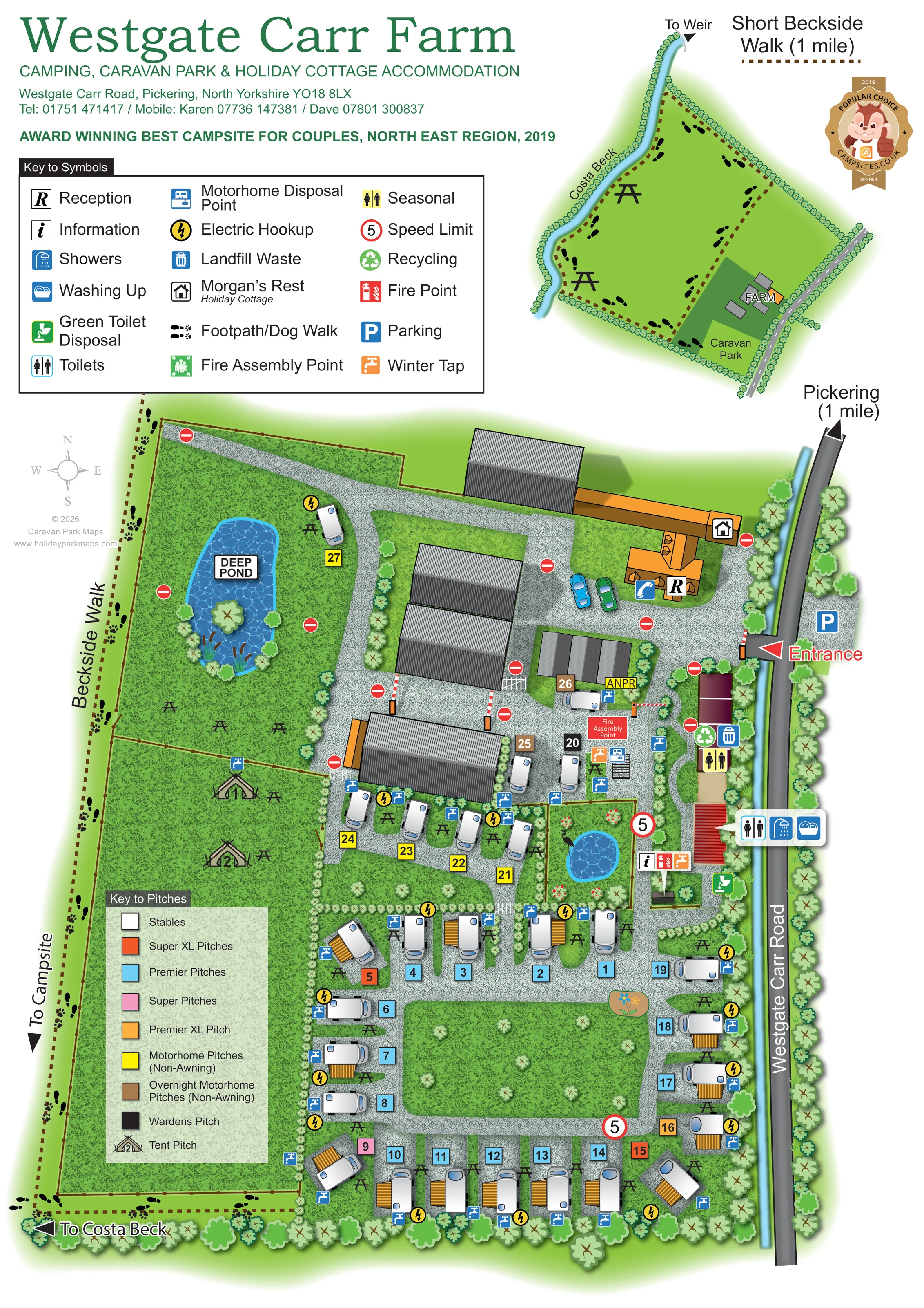
Deep pond and smaller garden pond
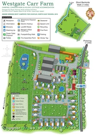
A large irregular pond labelled DEEP POND occupies the north-western grassed area, while a smaller pond sits in a planted enclosure near the facilities.
ILLUSTRATED PARK MAP · P362
Westgate Carr Road, Pickering, North Yorkshire · United Kingdom
 Enlarge the map ↗
A SENSE OF THE PLACE
Westgate Carr Farm offers adults-only camping and touring near Pickering, together with holiday cottage accommodation. Its rural location sits at the foot of the North York Moors.
Serviced, all-weather pitches are arranged in a parkland setting with beech hedging and open views. The operator emphasises wildlife habitats and the area's dark skies, with the map showing the layout of accommodation and shared spaces.
LOOK CLOSER
A large irregular pond labelled DEEP POND occupies the north-western grassed area, while a smaller pond sits in a planted enclosure near the facilities.
Tree-lined boundaries, low hedges, scattered trees and substantial lawns separate the pitches, buildings and walking areas.
Costa Beck is named on the walking inset, with a directional link from the south-western corner of the main plan.
An R symbol identifies reception in the orange-roofed building beside the entrance courtyard.
An information symbol appears beside the shared facilities on the eastern side.
A grouped set of toilet, shower and washing-up symbols identifies the roadside amenity building.
Yellow electrical symbols and blue tap symbols are distributed through the pitch areas; orange winter-tap symbols appear around the shared service area.
Motorhome disposal symbols mark service positions near the northern pitches and central service area.
An R symbol identifies reception in the orange-roofed building beside the entrance courtyard.
An information symbol appears beside the shared facilities on the eastern side.
A grouped set of toilet, shower and washing-up symbols identifies the roadside amenity building.
Yellow electrical symbols and blue tap symbols are distributed through the pitch areas; orange winter-tap symbols appear around the shared service area.
Motorhome disposal symbols mark service positions near the northern pitches and central service area.
The green disposal symbol is positioned beside the eastern amenity area.
Recycling and landfill-waste symbols are grouped beside the roadside facilities.
A fire-point symbol is shown near the information point, and a red Fire Assembly Point label marks the northern service courtyard.
A blue P symbol marks parking beside Westgate Carr Road, immediately outside the entrance.
Black picnic-table illustrations appear beside pitches, around the larger pond and along the walking inset.
Several large grey-roofed buildings occupy the northern part of the main plan; the walking inset labels the corresponding cluster FARM.
Stables are listed as a white category in the pitch key, without a clearly labelled location on the main plan.
The symbol key includes a Seasonal entry. Its use is not clearly established on the plan; seasonal describes a use and may overlap a physical accommodation type.
A large irregular pond labelled DEEP POND occupies the north-western grassed area, while a smaller pond sits in a planted enclosure near the facilities.
Tree-lined boundaries, low hedges, scattered trees and substantial lawns separate the pitches, buildings and walking areas.
Costa Beck is named on the walking inset, with a directional link from the south-western corner of the main plan.
The entrance branches from Westgate Carr Road into the reception courtyard. Barrier illustrations and an ANPR label mark the internal access point.
Pale textured drives form a compact loop around a central lawn, with branches serving the northern buildings and individual hardstandings.
Brown dashed lines, footprints and paw prints mark the western and southern walking route, with arrows towards Costa Beck and the campsite.
The upper-right inset is titled Short Beckside Walk (1 mile) and relates the farm and caravan park to the riverside route and a continuation towards a weir.
An arrow at the northern end of Westgate Carr Road is labelled Pickering (1 mile).
Red no-entry signs and circular 5 speed-limit symbols distinguish controlled courtyard access and internal circulation.
READING THE MAP
This illustrated map of Westgate Carr Farm brings a small rural touring park and its surrounding walks together on one portrait page. Set near Pickering in North Yorkshire, the park is shown as a compact arrangement of serviced pitches, farm buildings, a holiday cottage and open grassed spaces, with trees and hedges giving the plan a distinctly parkland character.
The main map follows the visitor journey from Westgate Carr Road into the reception courtyard and onwards to the touring pitches. Silver touring units, striped awnings and coloured pitch markers make the accommodation areas easy to distinguish, while a separate key explains the different pitch categories. Toilets, showers, washing up, disposal facilities and utilities are located using clear pictograms.
Landscape is an important part of the composition. A large pond and two marked tent pitches occupy the western side, and footprint-and-paw-print graphics trace the Beckside route around the boundary. An upper-right inset extends that walking story towards Costa Beck and the weir, allowing the page to serve as both a park guide and a local orientation map.
The artwork is a single portrait composition with a large illustrated site plan beneath the park heading and facility key. Westgate Carr Road forms the right-hand edge, with an entrance arrow leading into the northern courtyard. Reception is identified on an orange-roofed building, parking is marked beside the road, and barriers with an ANPR label show the transition into the internal pitch area. Large grey-roofed farm buildings and the symbol for Morgan’s Rest Holiday Cottage complete the northern cluster.
Below this, pale gravel drives organise the touring accommodation around a broad rectangular lawn. Most pitches face into this circulation loop, with a further row and several smaller pockets extending towards the buildings. Vehicle drawings, awnings and picnic tables give the pitches a recognisable appearance. Number squares distinguish Premier, Super, Super XL and Premier XL categories, as well as dedicated non-awning motorhome and overnight motorhome pitches. The key also identifies a wardens pitch and tent-pitch symbol.
Shared facilities sit mainly along the eastern side. Toilet, shower and washing-up symbols identify the amenity building, while nearby markers show information, recycling, landfill waste, toilet disposal and winter taps. Electric hook-ups and water taps recur through the pitch areas. Fire information and traffic symbols provide another layer of practical orientation.
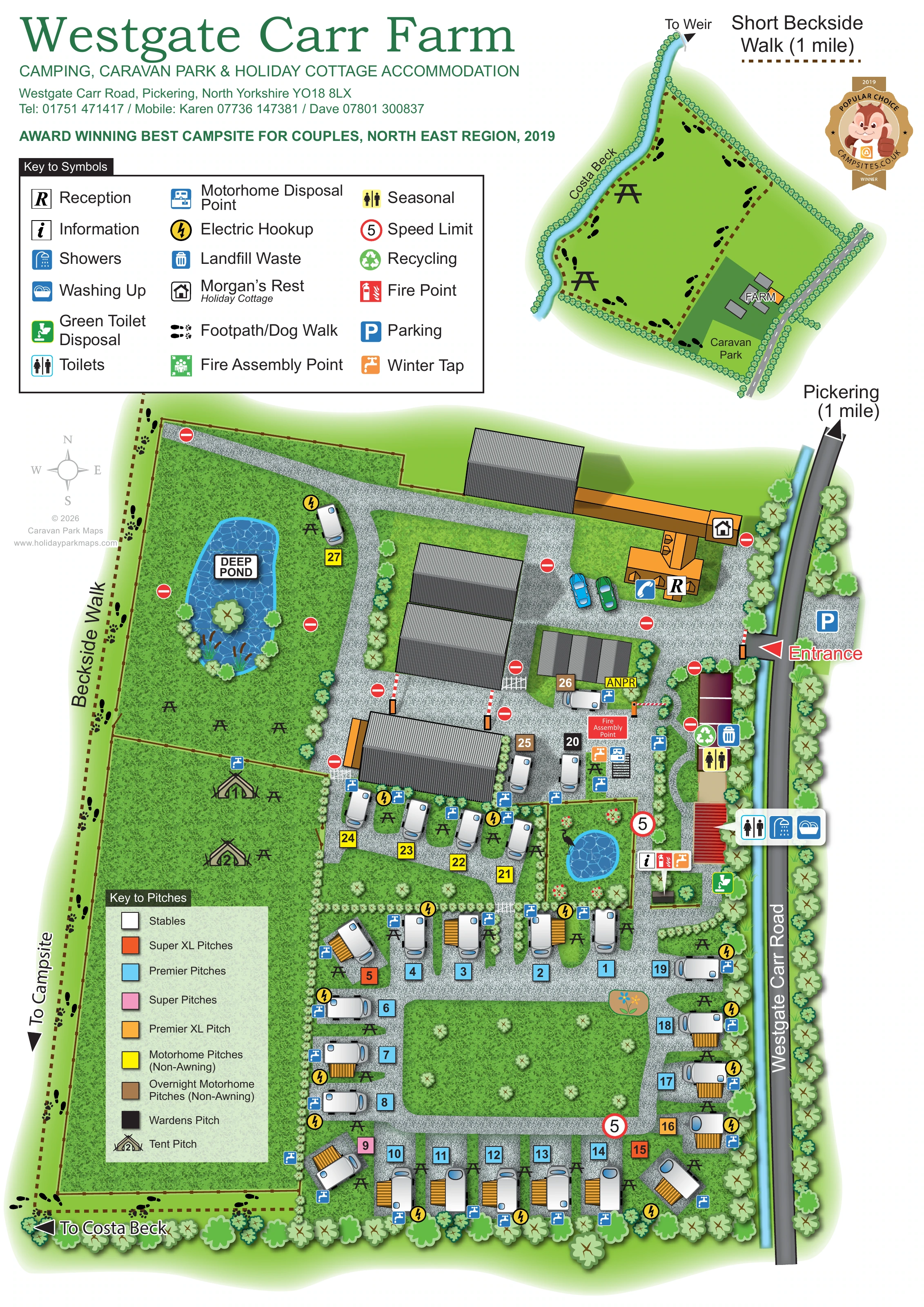
The western side is more open, containing two marked tent pitches, picnic tables and a large pond labelled DEEP POND. A smaller planted pond appears near the facilities. The dashed Beckside Walk follows the western and southern boundaries towards Costa Beck. In the upper-right inset, the one-mile Short Beckside Walk is shown in relation to the farm, caravan park, beck and direction to the weir. The detail enlargements repeat parts of this same page rather than presenting additional layouts.
KEEP EXPLORING
Chosen for shared landscapes, accommodation or facilities.
 Explore the map ↗
United Kingdom
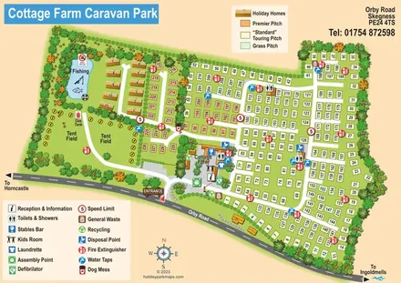
Illustrated touring and camping park map with numbered pitches, a fishing pond and a central farm courtyard.
 Explore the map ↗
United Kingdom
Woodland holiday-park map with named accommodation areas, touring loops and illustrated recreation facilities.
 Explore the map ↗
United Kingdom
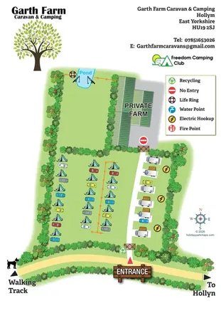
Illustrated farm campsite map with tent camping, electric touring bays, a pond and clearly marked private farm access.
Features may come from the sample artwork, its key or published park information. Approximate numbers describe the drawing and may cover only part of a park. They are intended to help you compare map examples. Current facilities and booking information should be checked with the park.
TAKE A CLOSER LOOK
View the illustrated map in detail or choose a file to download. These are sample maps; contact the park for current visitor information.


LET’S MAP YOUR PARK
For a map quotation, find your park and draw a rough boundary around it. The area you select helps us work out the design time and price.
Draw your park for a quote ↗Or talk to our map designers
01751 473136
 westgatecarrmap_large.png