
Woodland setting
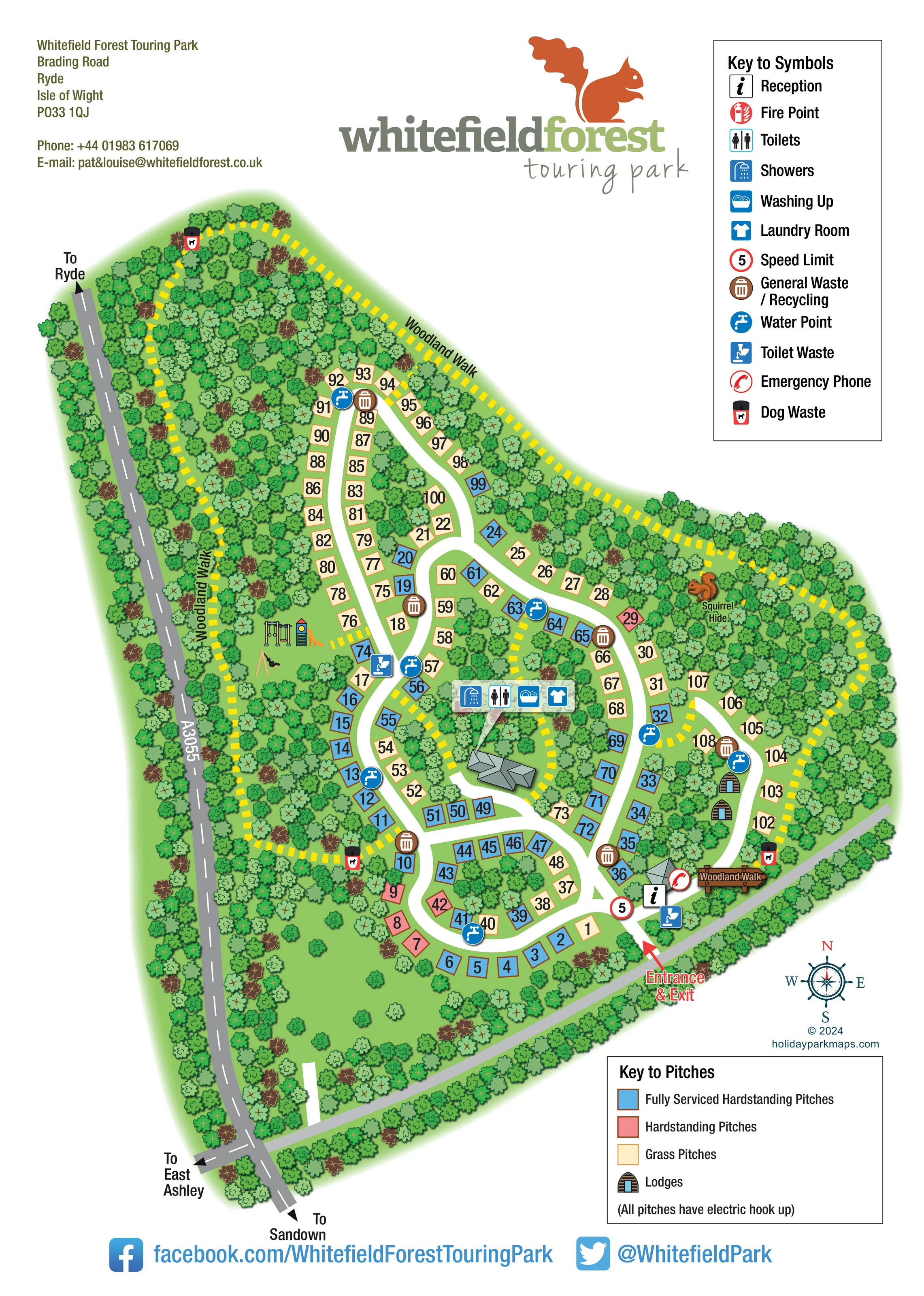
Dense illustrated trees surround the accommodation, separate many pitch groups and fill the long northern section.
ILLUSTRATED PARK MAP · P365
Whitefield Forest Touring Park, Brading Road, Ryde, Isle of Wight · United Kingdom
 Enlarge the map ↗
A SENSE OF THE PLACE
Whitefield Forest Touring Park is a family-run campsite between Ryde and Sandown on the Isle of Wight. Woodland surrounds its touring, camping and lodge accommodation.
Grass pitches and serviced hardstandings cater for different camping setups. A woodland walk, squirrel hide and play area encourage time outdoors, while local walking and cycling routes and a bus service offer ways to explore the island.
LOOK CLOSER
Dense illustrated trees surround the accommodation, separate many pitch groups and fill the long northern section.
An information symbol marks reception beside a small illustrated building near the entrance.
Toilet and shower symbols appear together in the central facilities cluster.
A washing-up symbol is included in the central facilities cluster.
The central facilities cluster includes the blue laundry-room symbol.
Blue tap symbols are distributed around the pitch roads, including the northern rows, central junctions and southern loop.
Toilet-waste symbols appear near the entrance and on the western side of the central pitch layout.
Brown bin symbols mark several disposal points throughout the accommodation area.
An information symbol marks reception beside a small illustrated building near the entrance.
Toilet and shower symbols appear together in the central facilities cluster.
A washing-up symbol is included in the central facilities cluster.
The central facilities cluster includes the blue laundry-room symbol.
Blue tap symbols are distributed around the pitch roads, including the northern rows, central junctions and southern loop.
Toilet-waste symbols appear near the entrance and on the western side of the central pitch layout.
Brown bin symbols mark several disposal points throughout the accommodation area.
Black-and-red bin symbols appear beside sections of the woodland route, including its northern and southern reaches.
A red telephone symbol is placed beside reception near the entrance.
A fire-point symbol is explained in the facilities key; no corresponding position is clearly identifiable on the plan.
A circular marker bearing the numeral 5 is shown just inside the entrance and explained in the symbol key.
The pitch key states that all pitches have electric hook-up.
Illustrated swings, a slide and other play equipment occupy a grassy clearing west of the central pitch roads.
The named squirrel hide is marked by an orange squirrel illustration in the eastern woodland.
Dense illustrated trees surround the accommodation, separate many pitch groups and fill the long northern section.
A thick yellow dashed route follows the wooded perimeter and branches through the central and eastern parts of the site. Repeated labels and a timber-style sign identify the walk.
A red arrow and prominent label mark the single depicted arrival point on the south-eastern edge, reached along a grey approach road.
White curving roads connect a southern loop, central branches and a long northern pitch corridor.
The A3055 runs along the western boundary, with arrows towards Ryde and Sandown and a side-road reference towards East Ashley.
READING THE MAP
This illustrated map of Whitefield Forest Touring Park presents a woodland touring and camping site on the Isle of Wight. Rather than treating the park as a simple grid of pitches, the design follows its winding roads, wooded edges and long northern section. Numbered accommodation plots sit within a dense canopy of illustrated trees, with blue, pink and cream fills distinguishing fully serviced hardstandings, other hardstandings and grass pitches.
The visitor journey begins at the clearly marked entrance near reception, then follows white internal roads towards the different pitch groups. A separate yellow dashed woodland walk threads around the site, bringing the surrounding landscape into the same practical guide. The squirrel hide, play area and two small lodge illustrations provide useful landmarks alongside the everyday service symbols.
The portrait page combines the site plan with two distinct keys, local road directions and the park's squirrel-led branding. It is a useful sample for woodland campsites that need to explain mixed pitch types and facilities while also showing the outdoor experiences that give the site its character.
The plan occupies most of a tall white page, with the A3055 running down its western edge and direction arrows towards Ryde, Sandown and East Ashley. A grey approach road crosses the lower edge to the south-eastern entrance, where a red arrow, reception symbol, emergency-phone marker and illustrated building establish the arrival area.
Inside the park, broad white roads form a southern loop and several curving branches. A longer road corridor extends into the narrow northern part of the woodland. Numbered pitch rectangles line these routes, using blue for fully serviced hardstandings, pink for hardstandings and cream for grass pitches. Two timber-front lodge symbols stand beside the eastern road. Larger grey-roofed buildings are drawn in a lightly oblique style, contrasting with the flatter pitch markers.
Water points and general-waste or recycling symbols are distributed among the pitch groups. Toilet-waste points appear near the entrance and farther west, while a central cluster identifies showers, toilets, washing-up facilities and laundry. The separate facilities key explains these symbols and also includes a fire-point entry.
The landscape is integral to the composition. Varied green tree crowns surround the pitches and create wooded pockets between the roads. A yellow dashed woodland walk traces much of the perimeter and connects through the interior, passing the named squirrel hide in the east. Illustrated play equipment occupies a clearing to the west, and dog-waste symbols mark several points beside the walking route.
A large squirrel logo crowns the page, balanced by contact details and the facilities key. The lower pitch key includes the electric hook-up note, with a compass rose and social-media footer completing the sheet. The accompanying enlargements show portions of this same artwork, not additional park sections.
KEEP EXPLORING
Chosen for shared landscapes, accommodation or facilities.
 Explore the map ↗
United Kingdom
Woodland-framed Barnsoul map with mixed accommodation, shared facilities and paw-marked walking routes.
 Explore the map ↗
United Kingdom
Woodland park map with mixed pitches, bell tents, lodges and a fishing lake.
 Explore the map ↗
United Kingdom
A colour-zoned coastal park map with touring areas, woodland trails, ponds and a leisure club.
Features may come from the sample artwork, its key or published park information. Approximate numbers describe the drawing and may cover only part of a park. They are intended to help you compare map examples. Current facilities and booking information should be checked with the park.
LET’S MAP YOUR PARK
For a map quotation, find your park and draw a rough boundary around it. The area you select helps us work out the design time and price.
Draw your park for a quote ↗Or talk to our map designers
01751 473136