ILLUSTRATED PARK MAP · P369

Wildside Highland Lodges

Wildside Highland Lodges, Whitebridge, South Loch Ness, Inverness · United Kingdom

Our signature illustrated styleExplore the detail ↗
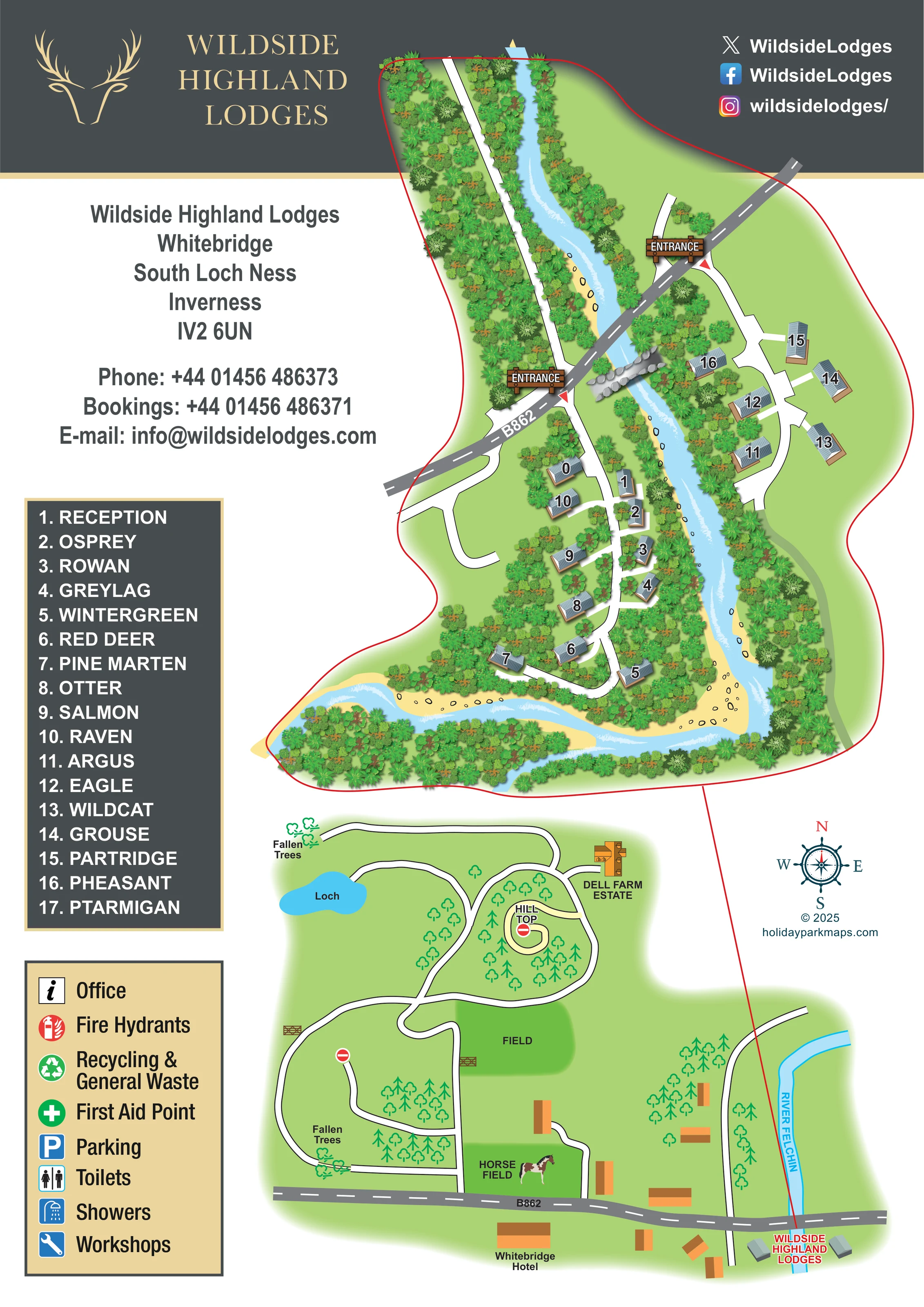
Illustrated map of Wildside Highland Lodges at Whitebridge, showing numbered grey-roofed lodges on both sides of a winding river, woodland, two B862 entrances and a named lodge key. A smaller map below shows surrounding routes, a loch, fields, Dell Farm Estate and Whitebridge Hotel.Enlarge the map ↗
Riverside lodge map with detailed woodland illustration and a surrounding-area route map.
LOCATIONUnited KingdomIV2 6UN
ACCOMMODATION IN THE RECORDLodges & cabins
APPROXIMATE MAP SCALEAbout 15 depicted units / pitchesFor comparing examples, not verified capacity.

A SENSE OF THE PLACE

About Wildside Highland Lodges

Wildside Highland Lodges is set beside the River Fechlin at Whitebridge in the Scottish Highlands. Woodland, hills and the nearby Loch Ness area shape the setting for a self-catering break.

Lodges offer different accommodation sizes, with private hot tubs and riverside or countryside outlooks. The map helps guests locate their lodge within the grounds and understand its relationship to the river.

What makes this map distinctive

  • Two levels of mapping on one portrait page: detailed lodge grounds and simplified surrounding routes
  • A red outline and leader line linking the enlarged plan to the local context
  • The river used as the organising shape of the accommodation layout
  • Gold antler branding against a charcoal header
  • Timber-style entrance sign illustrations
  • Wildlife- and plant-themed lodge names in a separate numbered directory

LOOK CLOSER

Features to find on the map

River Fechlin

The river separates the two lodge groups, curves around the lower end of the main plan and appears again in the surrounding-area map. Pale-blue water, white current marks, yellow banks and outlined stones make it the principal landscape feature.

Woodland and riverside planting

Dense, varied tree canopies surround the lodges and line the river in the enlarged plan; simpler green tree symbols represent woodland in the lower map.

Loch

A small blue waterbody labelled 'Loch' appears towards the upper left of the surrounding-area map; it is not labelled as Loch Ness.

Hill Top

A pale-yellow curling route and the label 'Hill Top' sit within a wooded loop in the lower map.

Field and horse field

Two darker-green areas are labelled 'Field' and 'Horse Field'; a horse illustration reinforces the latter as a surrounding-landscape landmark.

Fallen trees

Two locations on the lower route network are labelled 'Fallen Trees' and illustrated with small toppled-tree symbols.

Dell Farm Estate

A named neighbouring estate is shown with an orange-roofed building illustration beside the upper part of the surrounding route network.

Reception

Reception is identified in the numbered building key and positioned beside the internal route in the larger lodge cluster.

See all recorded map features
  • Reception Labelled on the map

    Reception is identified in the numbered building key and positioned beside the internal route in the larger lodge cluster.

  • River Fechlin Identified from the artwork

    The river separates the two lodge groups, curves around the lower end of the main plan and appears again in the surrounding-area map. Pale-blue water, white current marks, yellow banks and outlined stones make it the principal landscape feature.

  • Woodland and riverside planting Identified from the artwork

    Dense, varied tree canopies surround the lodges and line the river in the enlarged plan; simpler green tree symbols represent woodland in the lower map.

  • Two signed entrances Labelled on the map

    Two illustrated timber entrance signs mark turn-offs from the B862 on opposite sides of the river, accompanied by red triangular markers.

  • B862 Labelled on the map

    A grey road with a dashed white centre line crosses the enlarged site diagonally and runs across the bottom of the surrounding-area map.

  • Internal lodge access routes Identified from the artwork

    White, dark-edged routes branch towards individual lodges. The larger group has a curving lower loop, while the smaller group follows a separate riverside access spine.

  • Surrounding-area route network Identified from the artwork

    The lower map shows winding and looping routes between the B862, woodland, fields, a loch and Dell Farm Estate. Gate drawings and red no-entry symbols appear at selected points.

  • Loch Labelled on the map

    A small blue waterbody labelled 'Loch' appears towards the upper left of the surrounding-area map; it is not labelled as Loch Ness.

  • Hill Top Labelled on the map

    A pale-yellow curling route and the label 'Hill Top' sit within a wooded loop in the lower map.

  • Field and horse field Labelled on the map

    Two darker-green areas are labelled 'Field' and 'Horse Field'; a horse illustration reinforces the latter as a surrounding-landscape landmark.

  • Fallen trees Labelled on the map

    Two locations on the lower route network are labelled 'Fallen Trees' and illustrated with small toppled-tree symbols.

  • Dell Farm Estate Labelled on the map

    A named neighbouring estate is shown with an orange-roofed building illustration beside the upper part of the surrounding route network.

  • Whitebridge Hotel Labelled on the map

    The hotel is labelled beside a contextual building south of the B862 in the lower map; it is not presented as an on-site lodge facility.

  • Office symbol Listed in the map key

    An information-style office symbol is included in the facilities legend, without a clearly identifiable plotted position.

  • Fire hydrants Listed in the map key

    A red fire-hydrant symbol appears in the legend; individual hydrant locations are not clearly plotted.

  • Recycling and general waste Listed in the map key

    A green recycling symbol is explained in the legend, without a clearly identifiable location in the plan.

  • First aid point Listed in the map key

    A green cross appears in the legend; no corresponding point is clearly located on the map.

  • Parking Listed in the map key

    A blue parking symbol is included in the legend, but marked parking areas are not clearly identifiable.

  • Toilets and showers Listed in the map key

    Separate toilet and shower symbols appear in the facilities legend, without clearly plotted blocks or positions.

  • Workshops Listed in the map key

    A blue spanner symbol denotes workshops in the legend; a workshop location is not clearly shown.

  • Private lodge hot tubs From park research

    The park information describes lodges with private hot tubs. These are not separately identified in the illustrated plan.

READING THE MAP

The layout, landscape & routes

This illustrated map of Wildside Highland Lodges brings together a small riverside lodge development and the wider landscape around Whitebridge in the Scottish Highlands. The main plan follows the river as it passes between two lodge groups and bends around wooded grounds, making the water and trees central to the picture rather than a background decoration.

Grey-roofed lodges sit beside curving white access routes, with prominent numbers linked to a directory of wildlife- and plant-themed names. Two timber-style entrance signs identify the approaches from the B862. Below, a simpler surrounding-area map places the park in relation to Whitebridge Hotel, Dell Farm Estate, a loch, fields and a network of woodland routes.

The portrait composition balances practical guest information with a distinctive visual identity. A charcoal-and-gold header, antler emblem and generous contact panel sit alongside the illustrated grounds. For a lodge operator, this is a useful example of combining arrival orientation, accommodation finding and landscape context on a single guest-facing page.

Read the detailed map description

The upper plan is organised around the river, shown in pale blue with white current marks, sandy-yellow margins and scattered stones. Dense clusters of varied green tree canopies enclose the lodges and follow the banks. The larger accommodation group lies inside the lower river bend, where a white access spine branches towards individual buildings and curls into a loop. Across the water, a smaller group follows its own curved route through a more open green area.

The grey B862 crosses the composition diagonally. Two illustrated entrance signs mark the separate approaches, while large outlined building numbers connect the plan to a charcoal directory on the left. Reception appears in this directory alongside named lodges such as Osprey, Rowan, Pine Marten and Eagle. The buildings have ribbed grey roofs, brown bases or decking and light shadows, giving them a shallow three-dimensional appearance within the overhead landscape.

The lower map changes visual register. Flat green land, outlined tree symbols and simple orange-roofed buildings describe the surroundings without competing with the more detailed lodge plan. Its route network passes a labelled loch, Hill Top, Dell Farm Estate, a field and a horse field. Fallen-tree labels, gate drawings and no-entry symbols add local route detail. Whitebridge Hotel sits beside the B862, and the park is labelled next to the river. A red connecting line ties this location to the enlarged grounds above.

A separate cream legend explains office, fire-hydrant, recycling and waste, first-aid, parking, toilet, shower and workshop symbols, although their positions are not clearly marked in the plan. The page is completed by a compass rose, contact information, social-media identities and charcoal-and-gold park branding.

KEEP EXPLORING

More maps with a similar feel

Chosen for shared landscapes, accommodation or facilities.

About this sample & the collected information

Features may come from the sample artwork, its key or published park information. Approximate numbers describe the drawing and may cover only part of a park. They are intended to help you compare map examples. Current facilities and booking information should be checked with the park.

LET’S MAP YOUR PARK

Start with a line.
We’ll bring it to life.

For a map quotation, find your park and draw a rough boundary around it. The area you select helps us work out the design time and price.

Draw your park for a quote ↗

Or talk to our map designers
01751 473136

A quick question?

Tell us a little about your park or the style you have in mind.

Quick security check
Loading security code…

See how we use your details in our privacy policy.

Map preview

Save image

Zoom with the controls, then scroll to explore. Press Escape to close.

Map quote

Draw your park for a quote

Open full page ↗