
Woodland and planted boundaries
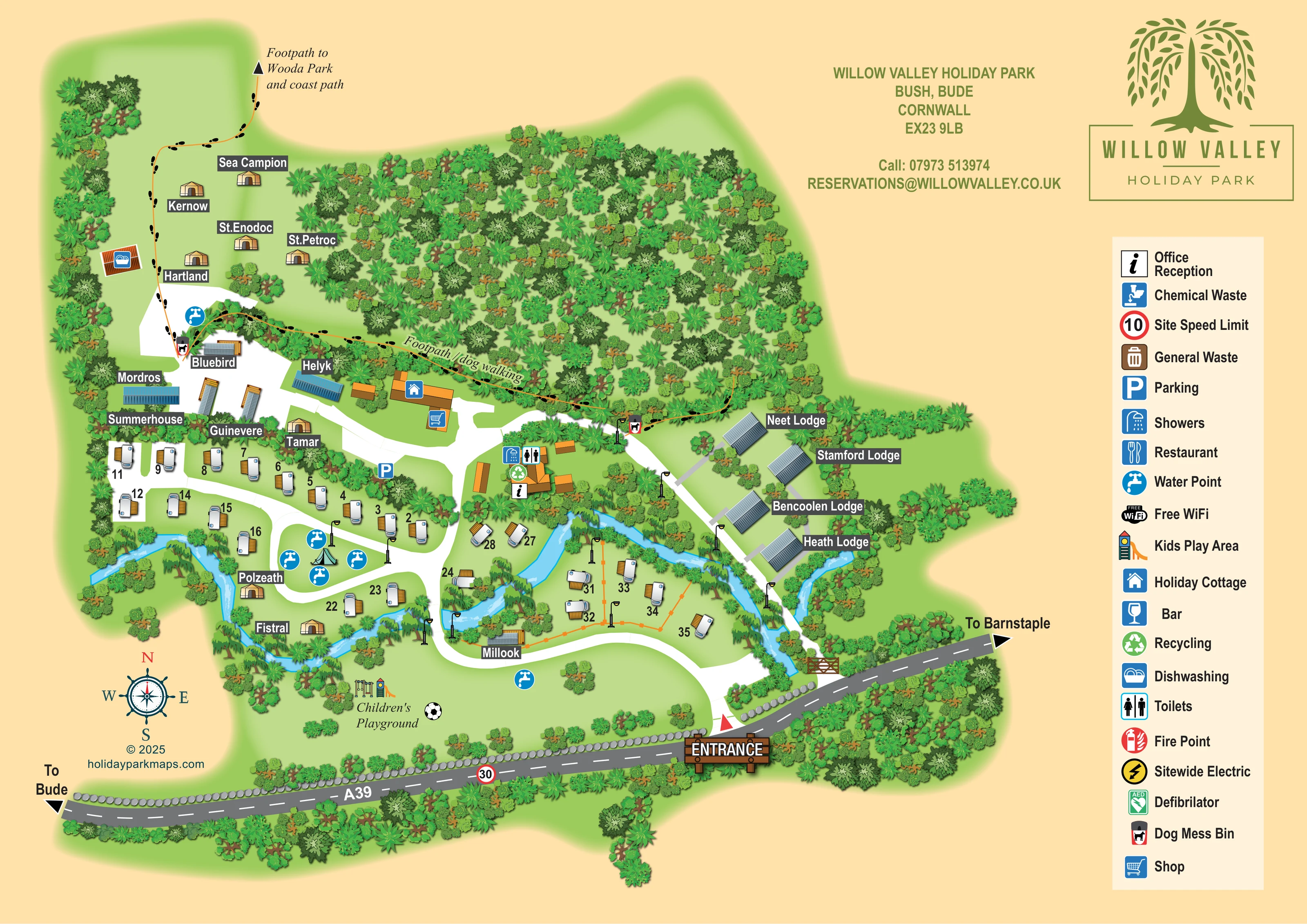
A large wooded area occupies the upper centre, with dense planting also enclosing accommodation, roads and watercourse banks.
ILLUSTRATED PARK MAP · P370
Willow Valley Holiday Park, Bush, Bude, Cornwall · United Kingdom
 Enlarge the map ↗
A SENSE OF THE PLACE
Willow Valley Holiday Park is based at Bush, Bude, Cornwall. The park is in a sheltered river valley about two miles inland from Bude, with 11 acres of valley and woodland. The current homepage lists 21 camping pitches across two fields, plus glamping accommodation and lodges. The park offers lodges with private hot tubs, including a larger lodge advertised for up to 12 guests.
Glamping options include bell tents, a shepherd’s hut, an Airstream and a converted American school bus. Dogs are welcome across the accommodation range, subject to the park’s dog policy, and a dog wash is provided.
LOOK CLOSER
A large wooded area occupies the upper centre, with dense planting also enclosing accommodation, roads and watercourse banks.
Bright blue, branching water runs through the lower accommodation areas and past the eastern lodges, with routes crossing between the banks.
An information symbol marks the central building cluster beside the showers, toilets and recycling.
A shopping-trolley symbol marks a building near the holiday cottage in the upper-central part of the occupied site.
Both symbols appear together at the central facilities cluster.
A dishwashing symbol marks a small roofed structure on the western edge of the upper glamping clearing.
Repeated blue tap symbols appear by the upper accommodation, around the central green island and near the playground.
A green recycling symbol is positioned at the central facilities.
An information symbol marks the central building cluster beside the showers, toilets and recycling.
A shopping-trolley symbol marks a building near the holiday cottage in the upper-central part of the occupied site.
Both symbols appear together at the central facilities cluster.
A dishwashing symbol marks a small roofed structure on the western edge of the upper glamping clearing.
Repeated blue tap symbols appear by the upper accommodation, around the central green island and near the playground.
A green recycling symbol is positioned at the central facilities.
A blue parking symbol appears beside the lane west of the reception cluster.
The southern open lawn is labelled Children’s Playground and illustrated with swings, a slide and a football motif.
Dog-bin symbols mark points along the woodland-edge walking route.
A large wooded area occupies the upper centre, with dense planting also enclosing accommodation, roads and watercourse banks.
Bright blue, branching water runs through the lower accommodation areas and past the eastern lodges, with routes crossing between the banks.
A timber-style entrance sign and red triangular marker identify access from the road along the southern edge. Directional arrows point towards Bude and Barnstaple.
Broad white lanes curve inland from the entrance, branch around the central pitches and extend towards the upper glamping area and eastern lodge row.
An orange route with black footprint motifs follows the southern edge of the main woodland.
The walking route continues north-west through the upper clearing to an outward arrow labelled Footpath to Wooda Park and coast path.
Included in the key; no clear position is identified on the illustrated plan.
A general-waste bin symbol is explained in the legend.
Separate restaurant and bar symbols appear in the key, without clearly identifiable placements on the plan.
These services are named in the legend rather than shown at specific locations.
Both safety symbols are included in the legend; their positions are not clearly established in the plan.
The legend includes a red-ringed 10 symbol labelled Site Speed Limit. The A39 separately carries an illustrated 30 sign.
Private hot tubs are described in the wider park information but are not explicitly identified on the artwork.
A dog wash is recorded in the park context, not located on this map.
READING THE MAP
This illustrated map of Willow Valley Holiday Park at Bush, near Bude in Cornwall, places the park’s wooded valley setting at the centre of its visitor information. A bright blue watercourse winds between accommodation areas, while dense tree planting frames the upper clearing, the eastern lodges and the park’s roadside boundary.
The map brings several kinds of holiday stay into one readable plan. Numbered caravan-style pitches sit alongside individually named tent-style accommodation, longer roofed units, four named lodges and a holiday cottage. Broad white lanes connect these areas to the entrance from the A39 and the central reception and facilities cluster.
Walking is given its own visual language: an orange line and black footprints trace the woodland-edge dog-walking route and continue towards Wooda Park and the coast path. A children’s playground occupies the open lawn near the southern boundary. With its willow-tree branding, charcoal accommodation labels and generous right-hand symbol key, this sample shows how a compact, varied holiday park can combine practical arrival information with a strong sense of landscape.
The single landscape-format artwork places the park plan across the left and centre, with the Willow Valley logo, contact details and a tall facilities key on the right. The A39 follows the lower edge, labelled with directions towards Bude and Barnstaple. A timber-style entrance sign and red pointer mark the arrival point near the south-eastern corner.
From here, a broad white lane curves into the park and branches towards the accommodation and central facilities. The reception cluster carries office, shower, toilet and recycling symbols. Nearby, a separate building group is marked with shop and holiday-cottage icons, while parking is identified beside the western lane. Water points recur around the occupied areas, and a dishwashing building sits beside the upper-left clearing.
Accommodation uses both numbers and names. Caravan-style symbols line the western lanes and a smaller riverside area to the east. Tan tent-style illustrations identify named stays such as Sea Campion, Kernow and Hartland in the upper clearing, with others beside the lower watercourse. Additional named roofed structures occupy the middle of the site. Neet, Stamford, Bencoolen and Heath Lodge form a clearly recognisable eastern row, each reached from the adjoining lane.
The stream and woodland are major organising features rather than background decoration. Blue water bends through the lower pitches and past the lodges, while varied tree canopies separate spaces and soften boundaries. An orange, footprint-marked route follows the woodland edge and continues towards Wooda Park and the coast path. The southern lawn contains the labelled children’s playground, illustrated with swings, a slide and a football motif. A compass rose completes the plan; the enlarged detail views show portions of this same artwork.
KEEP EXPLORING
Chosen for shared landscapes, accommodation or facilities.
 Explore the map ↗
United Kingdom
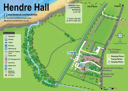
Coastal camping, touring and glamping map with a railway-side layout, beach path and illustrated rural surroundings.
 Explore the map ↗
United Kingdom
Woodland park map with mixed pitches, bell tents, lodges and a fishing lake.
 Explore the map ↗
United Kingdom
A colour-zoned coastal park map with touring areas, woodland trails, ponds and a leisure club.
Features may come from the sample artwork, its key or published park information. Approximate numbers describe the drawing and may cover only part of a park. They are intended to help you compare map examples. Current facilities and booking information should be checked with the park.
LET’S MAP YOUR PARK
For a map quotation, find your park and draw a rough boundary around it. The area you select helps us work out the design time and price.
Draw your park for a quote ↗Or talk to our map designers
01751 473136