
Memorial Gardens and Lodge Piece Gardens
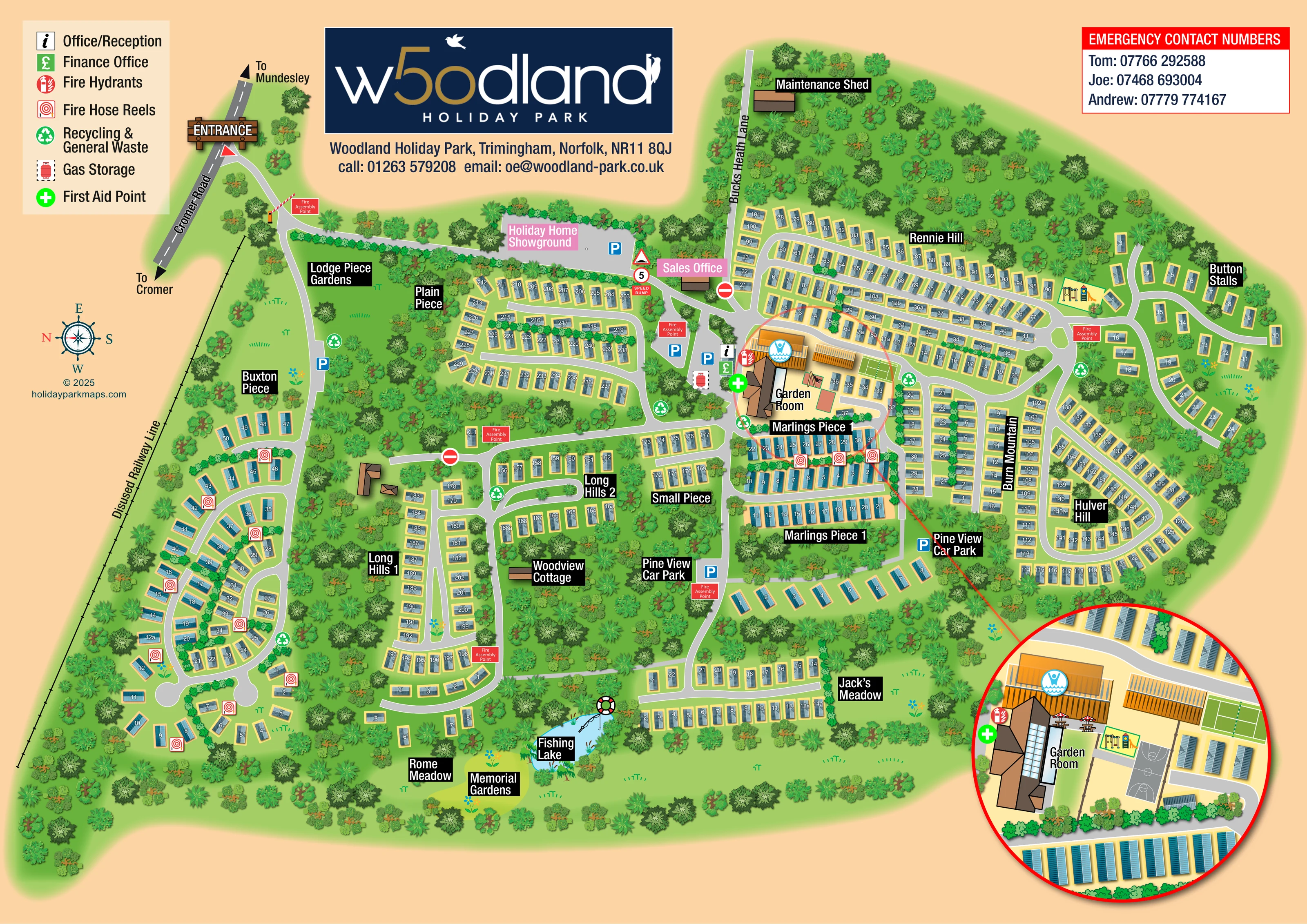
Two named garden areas provide open green landmarks, one beside the fishing lake and one close to the entrance road.
ILLUSTRATED PARK MAP · P372
Woodland Holiday Park, Trimingham, Norfolk · United Kingdom
 Enlarge the map ↗
A SENSE OF THE PLACE
Woodland Holiday Park is an owners-only holiday home park at Trimingham on the North Norfolk coast. Countryside and woodland surround the grounds between Cromer and Mundesley.
The park developed from a small touring site into its present holiday home setting. The map presents the accommodation layout and internal routes; the homes are intended for leisure use rather than permanent residence.
LOOK CLOSER
Two named garden areas provide open green landmarks, one beside the fishing lake and one close to the entrance road.
Dense tree planting surrounds the perimeter and separates accommodation sections, with hedges between many rows.
Named southern sections combine accommodation with open grass and surrounding trees.
A black line with repeated cross-marks follows the left-hand edge of the grounds.
Information and pound-sign symbols locate these functions beside the central building complex and parking.
Pink labels distinguish the sales office and broad showground area along the arrival road.
A named space within the central building complex, repeated at larger scale in the circular inset.
A blue swimmer symbol marks the orange-roofed facility beside the Garden Room; the map does not specify its operating arrangements.
Information and pound-sign symbols locate these functions beside the central building complex and parking.
Pink labels distinguish the sales office and broad showground area along the arrival road.
A named space within the central building complex, repeated at larger scale in the circular inset.
A blue swimmer symbol marks the orange-roofed facility beside the Garden Room; the map does not specify its operating arrangements.
A green court with white lines and a central net is shown beside the main leisure complex and enlarged in the inset.
The circular inset shows a grey court with basketball-style markings next to the play area.
Colourful climbing and slide equipment appears beside the Garden Room and near the junction between Rennie Hill and Button Stalls.
Picnic tables with parasols are illustrated beside the central buildings in the enlarged facility view.
A labelled blue lake near Rome Meadow and Jack’s Meadow is illustrated with reeds, a fishing rod and a lifebuoy.
Two named garden areas provide open green landmarks, one beside the fishing lake and one close to the entrance road.
Dense tree planting surrounds the perimeter and separates accommodation sections, with hedges between many rows.
Named southern sections combine accommodation with open grass and surrounding trees.
Blue parking symbols mark several locations, including the showground, central offices and two positions labelled Pine View Car Park.
A brown-roofed shed sits at the upper end of Bucks Heath Lane within woodland.
Repeated green recycling symbols identify waste locations across the road network; the legend defines them as recycling and general waste.
A red cylinder symbol marks gas storage near the central offices and parking.
A green cross locates a first aid point beside the central building complex.
Red hydrant symbols appear at the main complex, while repeated hose-reel symbols are distributed through accommodation areas.
Red labelled rectangles mark assembly points near the entrance and several internal road junctions.
A timber-style entrance sign and illustrated barrier emphasise the approach from Cromer Road.
Arrowheads at opposite ends of the depicted Cromer Road indicate the two destinations.
Grey roads link loops, branching rows and turning heads. No-entry symbols, a ‘5’ speed sign and a speed-bump marker are included.
A named lane extends from the sales-office junction towards the maintenance shed.
A black line with repeated cross-marks follows the left-hand edge of the grounds.
READING THE MAP
This illustrated map of Woodland Holiday Park at Trimingham, Norfolk, presents a large holiday-home estate as a collection of recognisable neighbourhoods within a wooded setting. Rather than treating the grounds as one continuous grid, the artwork gives each area a clear identity, from Buxton Piece and Plain Piece to Rennie Hill, Hulver Hill and Jack’s Meadow. Numbered homes follow curving roads, with trees, hedges and open green spaces helping to separate the groups.
The arrival sequence is particularly clear: Cromer Road leads to a prominent entrance sign, then past the holiday home showground towards the sales office and central facilities. A fishing lake, Memorial Gardens and Lodge Piece Gardens provide useful landscape landmarks away from the busier centre.
A circular enlargement brings the Garden Room and neighbouring leisure facilities into focus without crowding the main plan. Together with a compact service legend, parking symbols and bold section labels, it shows how an illustrated park map can support everyday orientation while retaining the character of a mature woodland holiday-home setting.
The single-page plan places the entrance at the upper left, with arrows along Cromer Road pointing towards Cromer and Mundesley. An illustrated barrier marks the approach, which continues beside the holiday home showground to the sales office and central road junction. Bucks Heath Lane runs upwards from this area to a maintenance shed surrounded by trees.
Accommodation is organised into several distinct road patterns. Buxton Piece follows branching curves beside the disused railway on the left-hand boundary. Plain Piece forms compact rows above the central woodland, while Long Hills 1, Long Hills 2 and Small Piece use straight stretches and rounded returns. To the right, long rows through Rennie Hill connect with the looser Button Stalls layout and the sweeping Hulver Hill circuit. Burn Mountain and Marlings Piece 1 occupy denser central groups, with smaller accommodation areas extending towards Pine View, Rome Meadow and Jack’s Meadow.
The central complex includes office/reception and finance symbols, a first aid point, gas storage and nearby parking. The Garden Room is labelled within the building group. A red-bordered circular inset enlarges this same location, revealing the swimming symbol, tennis court, basketball court, play equipment and outdoor tables with parasols. A second play area appears near Rennie Hill and Button Stalls.
Away from the centre, the labelled Fishing Lake and Memorial Gardens create a quieter visual focus along the lower edge. Lodge Piece Gardens provides another open landmark near the approach. Recycling and general waste symbols, fire hydrants, hose reels and assembly-point labels are distributed around the plan. Blue parking markers and white-on-black neighbourhood names help visitors move between these features and the individually numbered homes.
KEEP EXPLORING
Chosen for shared landscapes, accommodation or facilities.
 Explore the map ↗
United Kingdom
Illustrated lakeside park plan with numbered holiday units, leisure buildings and a looping Woodland Walk.
 Explore the map ↗
United Kingdom
Illustrated caravan park plan with woodland and riverside walks, fishing pools and wildlife panels.
 Explore the map ↗
United Kingdom
Fernwood's illustrated park plan combines numbered accommodation, woodland walks, a canal-side setting and an island-dotted lake.
Features may come from the sample artwork, its key or published park information. Approximate numbers describe the drawing and may cover only part of a park. They are intended to help you compare map examples. Current facilities and booking information should be checked with the park.
LET’S MAP YOUR PARK
For a map quotation, find your park and draw a rough boundary around it. The area you select helps us work out the design time and price.
Draw your park for a quote ↗Or talk to our map designers
01751 473136