
Stream
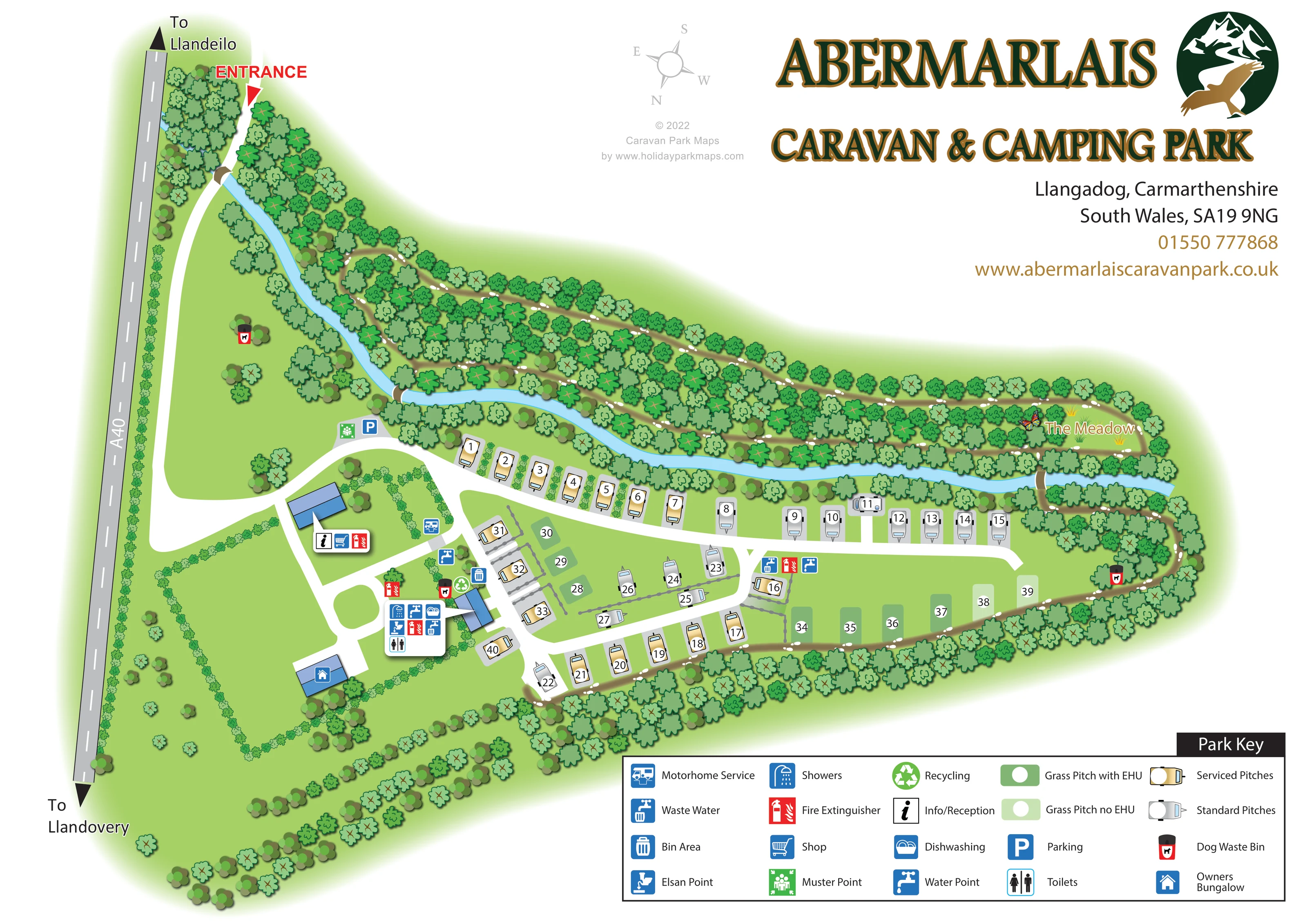
A pale-blue stream curves from the entrance side across the upper edge of the touring pitches, separating much of the accommodation from the wooded walking area.
ILLUSTRATED PARK MAP · P390
Llangadog, Carmarthenshire, South Wales · United Kingdom
 Enlarge the map ↗
A SENSE OF THE PLACE
Abermarlais Caravan Park is an adults-only touring park in the Towy Valley, with woodland, a stream and the landscapes of Bannau Brycheiniog nearby. It welcomes caravans, motorhomes, campervans, roof tents and trailer tents, with hardstanding and serviced pitches.
Woodland walks and a dog-friendly approach suit guests who enjoy time outdoors. A bus stop outside the park provides another way to explore the area. Conventional tent camping is not offered.
LOOK CLOSER
A pale-blue stream curves from the entrance side across the upper edge of the touring pitches, separating much of the accommodation from the wooded walking area.
Dense illustrated trees enclose the eastern and lower boundaries and form a broad wooded strip above the stream. Hedges and scattered trees divide the western grounds.
A named clearing at the upper-right end of the woodland route is illustrated with grass tufts and a butterfly.
An information/reception symbol is attached to the blue-roofed building beside the main arrival junction.
A shopping-trolley symbol places the shop with the reception building.
A grouped symbol panel beside the central blue-roofed service building identifies toilets, showers and dishwashing.
A blue motorhome-service symbol appears beside the access lane between reception and the main pitch area.
Elsan disposal is included in the central service cluster, with waste-water symbols there and beside the eastern pitch lane.
An information/reception symbol is attached to the blue-roofed building beside the main arrival junction.
A shopping-trolley symbol places the shop with the reception building.
A grouped symbol panel beside the central blue-roofed service building identifies toilets, showers and dishwashing.
A blue motorhome-service symbol appears beside the access lane between reception and the main pitch area.
Elsan disposal is included in the central service cluster, with waste-water symbols there and beside the eastern pitch lane.
Tap symbols identify water points near the central facilities and farther along the touring area.
General waste and recycling symbols are grouped beside the central service building.
Distinctive red-and-black dog-bin symbols appear near the central facilities, in the western grounds and on the eastern woodland route.
Red extinguisher symbols identify several locations, including reception, the central service area and the eastern pitch lane.
A green assembly symbol is positioned beside the parking area near the stream and arrival junction.
A blue P symbol marks parking just beyond the entrance drive, near the stream.
A separate blue-roofed building in the lower-left grounds carries the owners' bungalow symbol; it is not shown as guest accommodation.
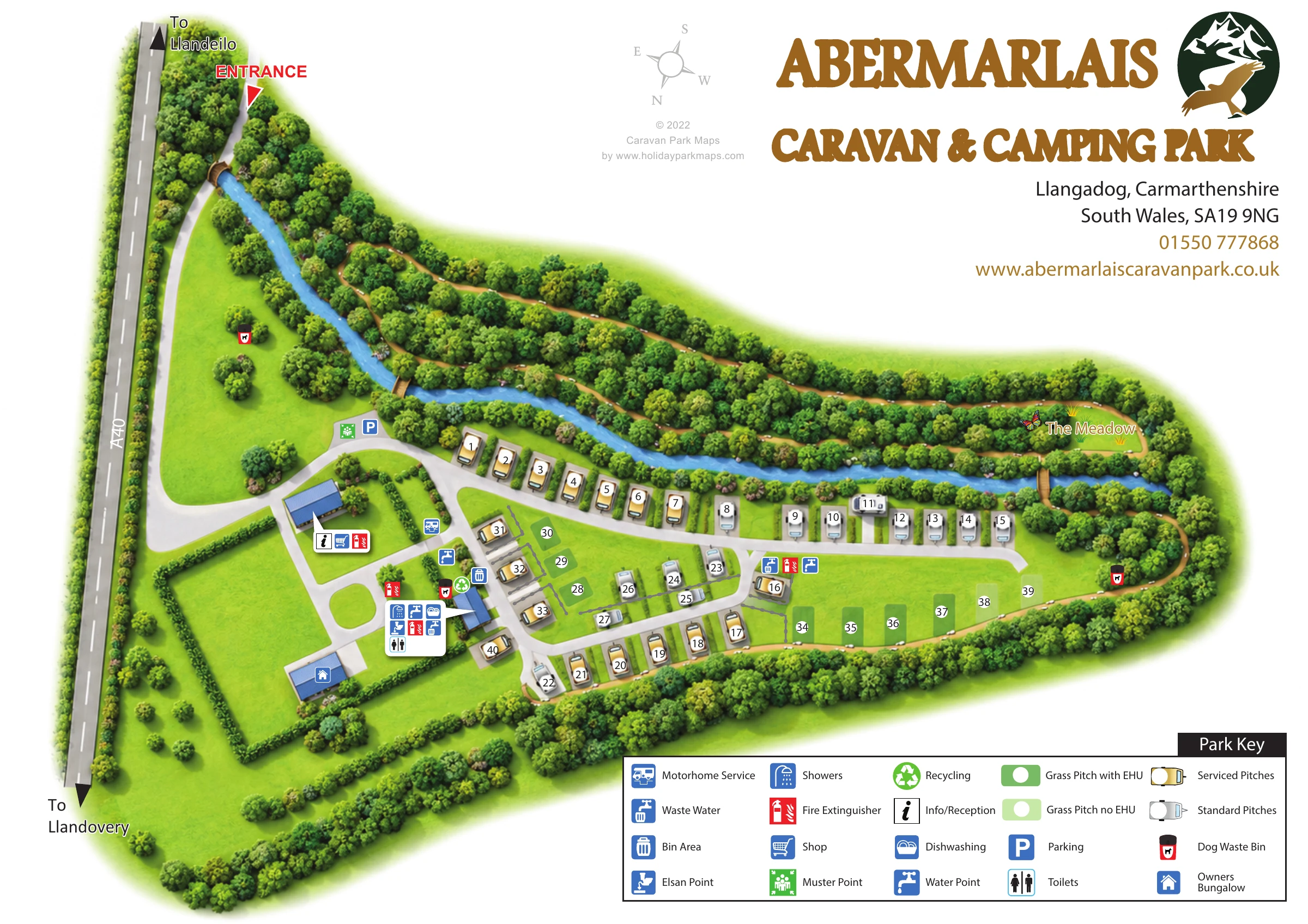
A pale-blue stream curves from the entrance side across the upper edge of the touring pitches, separating much of the accommodation from the wooded walking area.
Dense illustrated trees enclose the eastern and lower boundaries and form a broad wooded strip above the stream. Hedges and scattered trees divide the western grounds.
A named clearing at the upper-right end of the woodland route is illustrated with grass tufts and a butterfly.
Brown paths with repeated white footprint marks thread through the woodland, reach The Meadow and continue around the eastern and lower edges of the pitch area.
Small bridge-like crossings are illustrated near the entrance approach and between the eastern pitch area and The Meadow.
A red entrance arrow marks the upper-left access from the A40 into a curving internal drive.
Arrowheads at opposite ends of the illustrated A40 give the two town directions.
Broad white lanes connect the arrival buildings to the pitch rows, branch into the central accommodation group and terminate towards the eastern end.
READING THE MAP
This illustrated map of Abermarlais Caravan and Camping Park places a compact touring layout within its wooded setting at Llangadog, Carmarthenshire. A pale-blue stream runs through the composition, separating the main pitch area from a network of woodland paths and the clearing labelled The Meadow. The A40 and directions towards Llandeilo and Llandovery establish the arrival context along the left-hand edge.
The map shows roughly 40 pitches, with serviced and standard caravan pitches distinguished from grass pitches with and without electric hook-up. Reception, the shop and the central service building are easy to pick out through blue roofs and grouped facility symbols. A large key explains the accommodation treatments alongside practical services such as water, waste disposal, showers and parking.
For a design gallery, this sample demonstrates how a relatively small touring park can be mapped with both operational detail and a strong sense of place. Its woodland illustration, footprint-marked paths and prominent park branding give the page a character beyond a simple pitch plan.
The single landscape-format plan follows an elongated site stretching from the A40 on the left towards a wooded eastern end. A red entrance arrow leads into a sweeping white drive, which reaches the reception and shop building before branching towards parking, the central facilities and the touring pitches. The owners' bungalow is illustrated separately in the lower-left grounds.
Accommodation is organised around a long lane beside the stream and shorter branches through the centre. Gold caravan drawings identify serviced pitches, grey caravans identify standard pitches, and two shades of green distinguish grass pitches with and without electric hook-up. White circular number labels remain consistent across these different treatments. Small planted divisions and grey boundary marks help separate some of the pitch groups without overwhelming the roads.
The central blue-roofed service building is accompanied by a compact panel for toilets, showers, dishwashing, Elsan disposal and other practical facilities. Additional symbols locate the motorhome service point, water and waste-water points, bins, recycling, fire extinguishers and dog waste bins. Parking and the muster point sit near the arrival junction.
Landscape is a substantial part of the drawing. The stream curves along the upper side of the accommodation, while densely illustrated trees contain brown walking paths marked with white footprints. These routes lead through the woodland to The Meadow and continue around the eastern and lower boundaries. Small crossings connect routes across the water.
The upper-right white space carries the large green-and-ochre park title, emblem and contact block. A multi-column Park Key anchors the lower-right corner. The accompanying enlargement is a closer view of this same artwork, making the key, eastern grass pitches and meadow route easier to inspect.
 Enlarge this map ↗
KEEP EXPLORING
Chosen for shared landscapes, accommodation or facilities.
 Explore the map ↗
United Kingdom
Woodland park map with mixed pitches, bell tents, lodges and a fishing lake.
 Explore the map ↗
United Kingdom
A lakeside holiday-park and fishery map with numbered accommodation, fishing positions and clearly grouped visitor services.
 Explore the map ↗
United Kingdom
Wooded holiday-home park map with River Severn context, seasonal pitches and a clearly defined arrival area.
Features may come from the sample artwork, its key or published park information. Approximate numbers describe the drawing and may cover only part of a park. They are intended to help you compare map examples. Current facilities and booking information should be checked with the park.
TAKE A CLOSER LOOK
View the illustrated map in detail or choose a file to download. These are sample maps; contact the park for current visitor information.


LET’S MAP YOUR PARK
For a map quotation, find your park and draw a rough boundary around it. The area you select helps us work out the design time and price.
Draw your park for a quote ↗Or talk to our map designers
01751 473136