
Surrounding farm pasture
Large green fields containing small sheep illustrations occupy the space between the accommodation and Cove Road.
ILLUSTRATED PARK MAP · P168
Far Arnside, Silverdale · United Kingdom
 Enlarge the map ↗
A SENSE OF THE PLACE
Hollins Farm is a Holgates holiday park on a working farm at the foot of Arnside Knott. Its setting lies within the Arnside and Silverdale National Landscape.
Camping and glamping pods provide ways to stay in the countryside. Leisure facilities at the separate Silverdale Holiday Park are available nearby, including swimming and other indoor activities. The map shows Hollins Farm's own accommodation and camping layout.
LOOK CLOSER
Large green fields containing small sheep illustrations occupy the space between the accommodation and Cove Road.
Dense illustrated planting separates pitch groups; grey stone walls edge Cove Road and the arrival lane, while brown post-and-rail lines define other boundaries.
An information symbol marks reception in the building group labelled Hollins Cottage, beside the arrival parking.
Named buildings at the upper-left service and reception cluster; these are not presented as bookable holiday cottages.
Symbols are grouped on the amenity building beside A-Field. The wheelchair symbol identifies facilities without specifying their accessibility provision.
A pot-washing symbol is positioned on the main amenity building.
A washing-machine symbol identifies laundry at the lower end of the amenity building.
A pool-table pictogram marks the games room within the amenity building cluster.
An information symbol marks reception in the building group labelled Hollins Cottage, beside the arrival parking.
Named buildings at the upper-left service and reception cluster; these are not presented as bookable holiday cottages.
Symbols are grouped on the amenity building beside A-Field. The wheelchair symbol identifies facilities without specifying their accessibility provision.
A pot-washing symbol is positioned on the main amenity building.
A washing-machine symbol identifies laundry at the lower end of the amenity building.
A pool-table pictogram marks the games room within the amenity building cluster.
A swing illustration marks a small fenced play enclosure between the arrival parking and amenity building.
Marked bays appear beside reception and along the arrival lane, with another parking symbol near the junction of B- and C-Fields.
General waste and recycling symbols are grouped beside the play area and amenity cluster.
A yellow disposal symbol is placed just beyond the lower end of the amenity building.
A water tap is marked in A-Field, and red fire-point symbols recur along the pitch routes and beside the facilities.
A red entrance arrow identifies the turn off Cove Road. Two illustrated barrier arms mark the transition from the reception area to the pitch roads.
The grey boundary road carries directional arrows towards Arnside and towards Silverdale and Holgates.
Pink dotted routes follow the arrival side of the park and branch towards Arnside and Far Arnside.
A labelled footpath continues beyond the entrance towards the separate leisure complex; the complex itself is not depicted.
Large green fields containing small sheep illustrations occupy the space between the accommodation and Cove Road.
Dense illustrated planting separates pitch groups; grey stone walls edge Cove Road and the arrival lane, while brown post-and-rail lines define other boundaries.
The facilities key includes a red-bordered '10' speed symbol, but a corresponding location is not clearly shown on the plan.
A no-entry symbol appears in the key without a clearly identifiable placement on the plan.
READING THE MAP
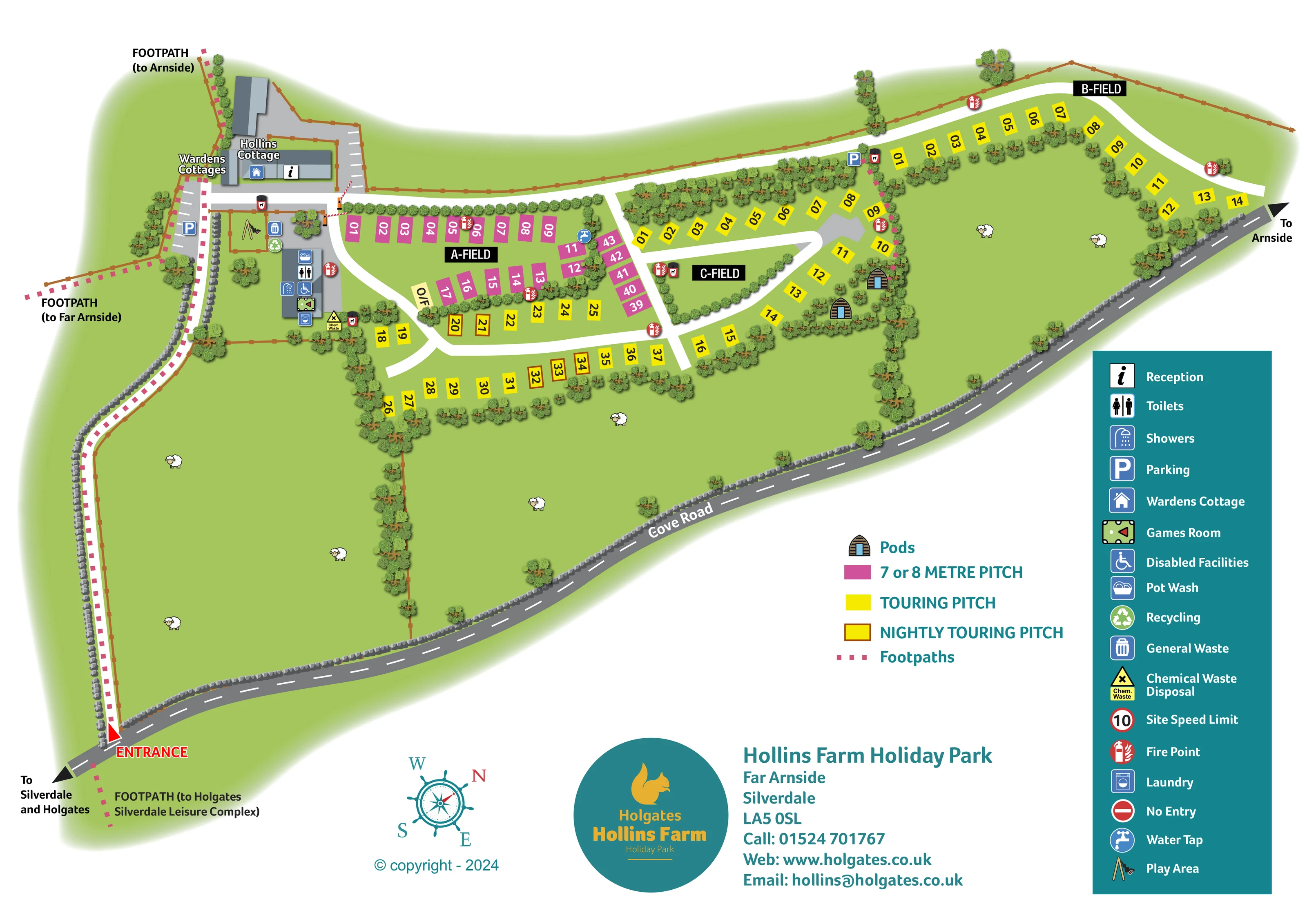
This illustrated map of Hollins Farm Holiday Park brings together a three-field pitch layout and the surrounding character of a working farm at Far Arnside, Silverdale. The accommodation occupies the upper part of the plan, while broad green pasture, scattered sheep, hedgerows and stone walls establish the countryside setting. Cove Road curves around the lower boundary, giving visitors a clear reference for the entrance and directions towards Arnside, Silverdale and Holgates.
The map uses bold colour coding to make the accommodation easy to recognise: yellow touring pitches, magenta 7 or 8 metre pitches and outlined yellow nightly touring pitches. Two timber pod illustrations add a different accommodation form beside C-Field. Reception, parking and the main amenity building are brought together near the end of the arrival lane, with symbols for washrooms, laundry, a games room and other practical facilities.
Pink dotted footpaths connect the site with nearby destinations, including the separate Holgates Silverdale Leisure Complex. Teal legends and a circular Holgates logo complete a design that balances everyday visitor navigation with a recognisable rural identity.
The plan begins at the lower-left entrance off Cove Road. A long lane follows the stone-walled boundary to the reception and cottage buildings, where parking bays and a small fenced play area establish the arrival hub. Illustrated barrier arms mark the onward access to the accommodation roads. Beside A-Field, a grey amenity building carries a compact stack of symbols for toilets, showers, disabled facilities, pot washing, a games room and laundry. Recycling, general waste and chemical disposal are shown nearby.
Three black name panels divide the accommodation into A-, B- and C-Fields. A-Field contains both magenta size-defined pitches and yellow touring pitches, arranged along curving roads and hedged rows. Several yellow pitches have a contrasting outline for nightly touring use. B-Field follows the long outer road around a large open pasture, while C-Field has a tighter triangular arrangement of roads and planting. Two arched timber pods sit along C-Field's outer hedge. Fire points recur around the layout, and a water tap is marked in A-Field.
The landscape is integral to the drawing. Layered tree and shrub symbols separate pitch groups, brown fences define field edges, and small sheep illustrations identify the surrounding farm pasture. Cove Road is drawn in grey with a dashed centre line, contrasting with the broad white internal roads. Magenta dotted footpaths lead towards Arnside, Far Arnside and the Holgates Silverdale Leisure Complex.
A tall teal facilities legend occupies the right side, with a separate accommodation key below the main plan. The lower margin contains the compass, Holgates squirrel branding and park contact block. The complete artwork is a single landscape-format map without inset plans.
KEEP EXPLORING
Chosen for shared landscapes, accommodation or facilities.
 Explore the map ↗
United Kingdom
Woodland-framed Barnsoul map with mixed accommodation, shared facilities and paw-marked walking routes.
 Explore the map ↗
United Kingdom
Woodland park map with mixed pitches, bell tents, lodges and a fishing lake.
 Explore the map ↗
United Kingdom
A colour-zoned coastal park map with touring areas, woodland trails, ponds and a leisure club.
Features may come from the sample artwork, its key or published park information. Approximate numbers describe the drawing and may cover only part of a park. They are intended to help you compare map examples. Current facilities and booking information should be checked with the park.
LET’S MAP YOUR PARK
For a map quotation, find your park and draw a rough boundary around it. The area you select helps us work out the design time and price.
Draw your park for a quote ↗Or talk to our map designers
01751 473136