
Fenced croft fields and livestock illustrations
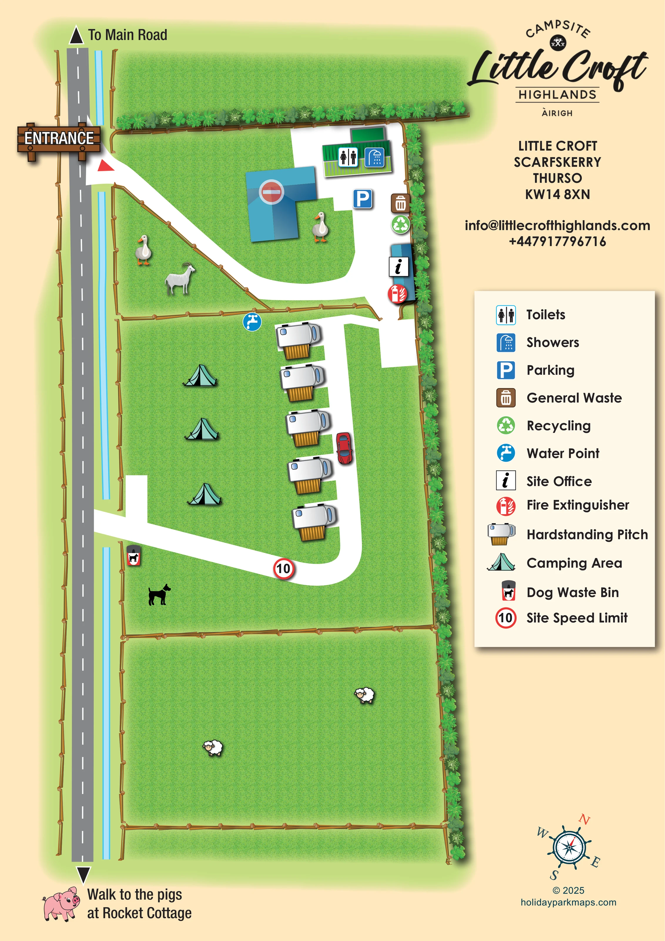
Timber fencing divides the long grassy croft into sections. Sheep appear in the lower field, with a goat and waterfowl near the upper buildings.
ILLUSTRATED PARK MAP · P192
Little Croft, Scarfskerry, Thurso · United Kingdom
 Enlarge the map ↗
A SENSE OF THE PLACE
Little Croft Highlands - Campsite & Airigh is based at Little Croft, Scarfskerry, Thurso. This is a small independent croft campsite near Scarfskerry harbour, just off the NC500 route. Five campervan/motorhome pitches are advertised, with electric hook-up available; tents are also accepted.
Toilets, shower, washing-up facilities and a communal Wi-Fi area are provided.
LOOK CLOSER
Timber fencing divides the long grassy croft into sections. Sheep appear in the lower field, with a goat and waterfowl near the upper buildings.
Dense illustrated shrubs follow the upper field boundary and the long right-hand edge of the site.
Toilet and shower symbols are placed on the green-roofed amenity building in the upper service yard.
A blue parking symbol marks the white-surfaced yard near the amenity building.
Separate brown waste and green recycling symbols are grouped along the right-hand edge of the service yard.
A blue tap symbol marks a water point at the upper edge of the camping field, close to the first hardstanding pitch.
The information symbol identifies a small blue building beside the route between the service yard and pitch area.
A red extinguisher symbol is shown beside the site office.
Toilet and shower symbols are placed on the green-roofed amenity building in the upper service yard.
A blue parking symbol marks the white-surfaced yard near the amenity building.
Separate brown waste and green recycling symbols are grouped along the right-hand edge of the service yard.
A blue tap symbol marks a water point at the upper edge of the camping field, close to the first hardstanding pitch.
The information symbol identifies a small blue building beside the route between the service yard and pitch area.
A red extinguisher symbol is shown beside the site office.
A dog waste bin symbol appears beside the lower connection to the roadside. A nearby dog silhouette adds visual context without naming a designated dog exercise area.
A large illustrated timber ENTRANCE sign marks the upper turn from the road into the croft.
A broad white lane curves through the upper yard, runs beside the motorhome pitches and bends back towards a lower roadside connection.
An arrow at the top of the grey roadside route is labelled 'To Main Road'.
A downward arrow and pink pig illustration indicate an off-map walk to the pigs at Rocket Cottage; the cottage itself is not depicted.
A red-ringed '10' sign is placed on the lower bend and identified in the legend as the site speed limit.
Timber fencing divides the long grassy croft into sections. Sheep appear in the lower field, with a goat and waterfowl near the upper buildings.
Dense illustrated shrubs follow the upper field boundary and the long right-hand edge of the site.
READING THE MAP
This illustrated map presents Little Croft Highlands as a small croft campsite at Scarfskerry, near Thurso. Its tall portrait format follows the shape of the land: a roadside route runs down the left, while fenced grass fields, a compact service yard and a short row of motorhome pitches fill the main plan. Open camping is shown with mint-green tents, making the two accommodation types easy to distinguish without introducing a numbered pitch system.
The croft setting is part of the map's character. Sheep, a goat and waterfowl appear among the fields and buildings, and a pig illustration accompanies the walking direction to Rocket Cottage. Practical information remains prominent, with symbols for toilets, showers, parking, water, waste, recycling and the site office.
A warm cream information column brings together the Little Croft branding, address, contact details and a generous symbol key. The result is a small-site map that explains arrival and everyday facilities while retaining the personality of a rural Highlands campsite.
The plan is arranged around a long grey roadside route on the left, with 'To Main Road' at its upper end and 'Walk to the pigs at Rocket Cottage' below. A timber-style ENTRANCE sign marks the upper turn into the site. From here, a broad white access lane curves around the upper grass and buildings before reaching the service yard on the right.
The green-roofed amenity building carries toilet and shower pictograms. Nearby symbols identify parking, general waste and recycling, while the smaller blue building below is marked as the site office. A fire extinguisher symbol sits alongside it. The larger blue L-shaped building is illustrated with a no-entry symbol but is not otherwise named.
Below the yard, roughly five motorhome hardstandings form a single row beside the white lane. Mint-green tents identify the open grass camping area to their left, and a water point is placed near the field's upper boundary. The lane bends around the bottom of the pitches and connects back towards the roadside. A red-ringed '10' speed sign and a dog waste bin appear near this lower section.
Timber fences divide the croft into clear compartments. The lower field contains sheep illustrations, while a goat and waterfowl add character near the upper buildings. Dense shrub planting follows the top and right-hand boundaries. A substantial legend occupies the right-hand information column beneath the logo and contact block, with a decorative compass near the foot of the page. This is one continuous site plan, without a separate inset or walking-map panel.
KEEP EXPLORING
Chosen for shared landscapes, accommodation or facilities.
 Explore the map ↗
United Kingdom
Illustrated touring and camping map with hedge-divided fields, age-labelled play areas and a detailed service key.
 Explore the map ↗
United Kingdom
Woodland park map with mixed pitches, bell tents, lodges and a fishing lake.
 Explore the map ↗
United Kingdom
Tree-framed mixed-accommodation park map with two entrances, touring loops and a clearly illustrated social hub.
Features may come from the sample artwork, its key or published park information. Approximate numbers describe the drawing and may cover only part of a park. They are intended to help you compare map examples. Current facilities and booking information should be checked with the park.
LET’S MAP YOUR PARK
For a map quotation, find your park and draw a rough boundary around it. The area you select helps us work out the design time and price.
Draw your park for a quote ↗Or talk to our map designers
01751 473136