
Fishing lakes
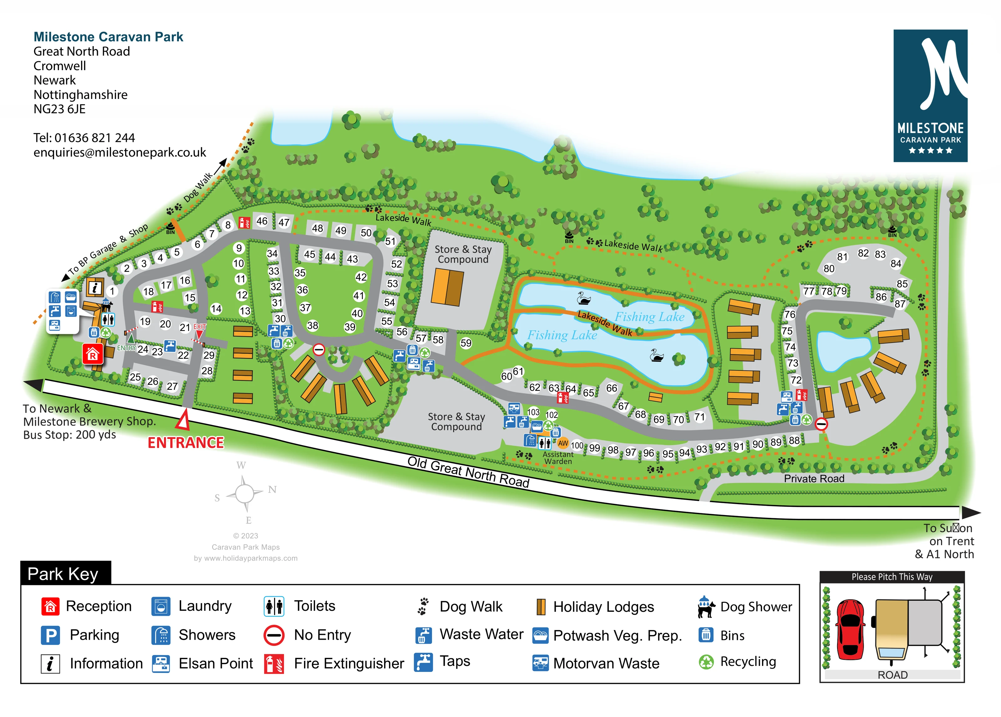
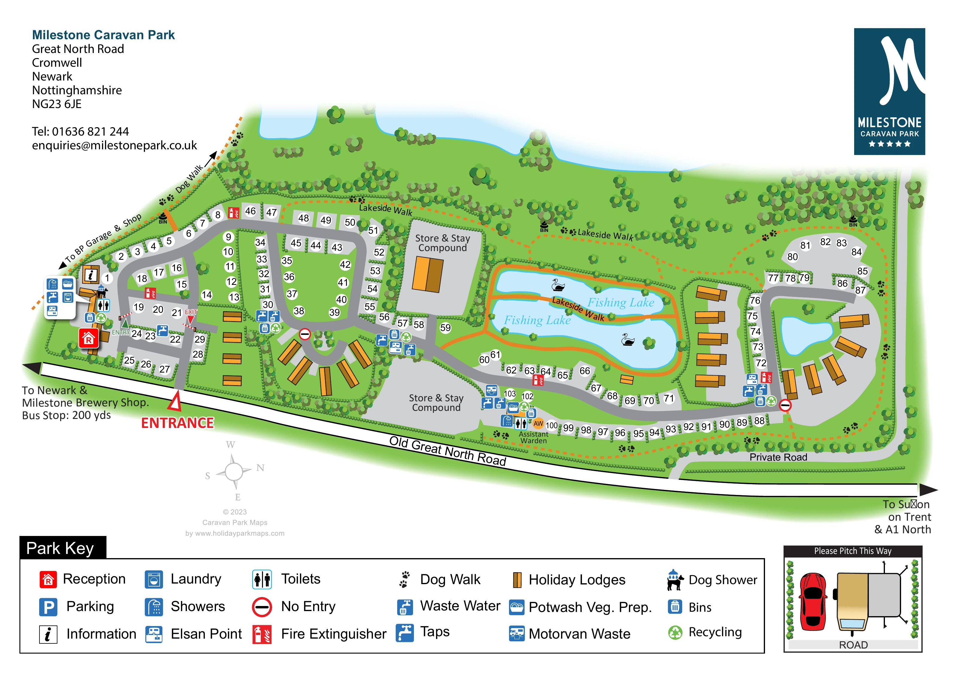
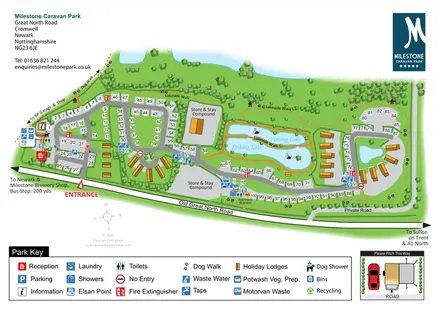
Two adjoining blue water areas in the centre-right are labelled Fishing Lake and illustrated with swans.
ILLUSTRATED PARK MAP · P541
Great North Road, Cromwell, Newark, Nottinghamshire · United Kingdom
 Enlarge the map ↗
A SENSE OF THE PLACE
Milestone Caravan Park is a touring site near Cromwell, north of Newark-on-Trent. Its position close to the A1 makes it suitable both as a stopping place and as a base for exploring Nottinghamshire.
Caravans and motorhomes are welcomed, including club members and non-members. Newark, Southwell, Lincoln and Nottingham provide options for outings, while the map gives visitors a practical view of the pitch layout.
LOOK CLOSER
Two adjoining blue water areas in the centre-right are labelled Fishing Lake and illustrated with swans.
A small unlabelled pond lies inside the eastern loop, while larger blue water shapes extend along the upper edge of the depiction.
Hedges divide pitches and enclose accommodation groups; scattered trees and denser planting frame the northern and eastern margins.
A prominent red reception symbol marks the arrival area on the western side.
An information symbol appears near reception and the western service buildings.
Blue and black pictograms identify sanitary and laundry facilities in the western arrival cluster and the lower central service cluster.
Dishwashing and vegetable preparation symbols appear within service clusters.
Repeated service symbols are distributed between pitch groups, including water taps, waste-water disposal and chemical toilet disposal points.
A prominent red reception symbol marks the arrival area on the western side.
An information symbol appears near reception and the western service buildings.
Blue and black pictograms identify sanitary and laundry facilities in the western arrival cluster and the lower central service cluster.
Dishwashing and vegetable preparation symbols appear within service clusters.
Repeated service symbols are distributed between pitch groups, including water taps, waste-water disposal and chemical toilet disposal points.
A motorvan waste symbol is marked beside the lower central facilities, close to the southern pitch row.
Bin and recycling symbols accompany service clusters; additional black bin symbols appear along the walking routes.
Red extinguisher markers stand out at several points around the touring areas.
Distinctive dog-and-shower pictograms appear at the western facilities and lower central service area.
Parking is included in the Park Key, but a corresponding location is not clearly identifiable on the plan.
Two grey areas labelled Store & Stay Compound occupy the centre of the site, one above and one below the main internal road.
An Assistant Warden label and circular AW marker sit beside the lower central facilities.
Two adjoining blue water areas in the centre-right are labelled Fishing Lake and illustrated with swans.
A small unlabelled pond lies inside the eastern loop, while larger blue water shapes extend along the upper edge of the depiction.
Hedges divide pitches and enclose accommodation groups; scattered trees and denser planting frame the northern and eastern margins.
Orange walking routes are labelled Lakeside Walk across the upper green belt and beside and between the fishing lakes.
A labelled dog-walk route at the north-west connects with a wider orange dashed circuit marked by paw prints around the park edges.
The main entrance branches from Old Great North Road near the western end. Directional labels point towards Newark and Milestone Brewery Shop, and towards Sutton on Trent and the A1 north.
A north-west arrow points to a BP garage and shop. The Newark direction annotation also references a bus stop.
A separate grey road labelled Private Road follows the lower eastern boundary and joins Old Great North Road.
Entry and exit labels, barrier drawings and no-entry signs explain selected internal connections. A separate inset illustrates caravan, car and awning orientation beside the road.
READING THE MAP
This map of Milestone Caravan Park brings together touring pitches, holiday lodges and lakeside walks in an elongated site beside Old Great North Road at Cromwell, near Newark in Nottinghamshire. Its overhead layout makes the relationship between the entrance, reception, accommodation loops and central fishing lakes easy to follow without losing the park’s planted character.
Numbered touring pitches sit along curving grey roads and within hedge-divided groups. Gold lodge symbols provide a clear visual contrast, while blue service icons identify practical destinations such as showers, laundry, water points and waste facilities. Orange walking routes connect the lakeside landscape with a dog-walk circuit around the park’s edges.
The page also gives space to details that matter on arrival: local road directions, entry and exit markings, two Store & Stay compounds and a separate illustration showing how to position a caravan, car and awning. A broad Park Key anchors the composition, with the park’s dark-teal branding balancing the contact information above.
The plan is organised around Old Great North Road, which runs along the lower edge of the artwork. A clearly marked entrance leads into the western touring area, with reception and an information point positioned to the left. Entry and exit annotations and small barrier drawings distinguish local circulation around this arrival section.
Grey internal roads curve through several accommodation groups. In the west, numbered pitches line both sides of the roads and occupy narrow, hedge-separated islands. Nearby lodges appear as gold roof-like rectangles, including a fan-shaped group around a short circular approach. The middle of the plan contains two labelled Store & Stay compounds, with service symbols concentrated at the connections between neighbouring pitch areas.
Two blue fishing lakes dominate the centre-right. Orange paths follow their edges and pass between them, linking to the wider Lakeside Walk across the upper green belt. Swans, scattered trees and denser boundary planting give this part of the map a different character from the numbered touring areas. Farther east, another road loop contains touring pitches, lodge groups and a small unlabelled pond. A long pitch row follows the southern side of the internal road.
Repeated pictograms identify toilets, showers, laundry, potwash and vegetable preparation, taps, disposal points, bins, recycling and fire extinguishers. Dog-shower symbols and paw prints add specific pet-related wayfinding. Below the plan, the large Park Key explains the symbols, while the ‘Please Pitch This Way’ inset illustrates vehicle and awning orientation. The detail views enlarge this same key and inset; they are not separate park sections.
KEEP EXPLORING
Chosen for shared landscapes, accommodation or facilities.
 Explore the map ↗
United Kingdom
Woodland park map with mixed pitches, bell tents, lodges and a fishing lake.
 Explore the map ↗
United Kingdom
Illustrated farm holiday park plan combining riverside pitches, lakeside accommodation, animal fields and paw-print walking routes, with separate accommodation and facilities keys.
 Explore the map ↗
United Kingdom
Colour-coded touring and camping map beside Afon Llafar and Bala Lake, with bilingual Glanllyn branding.
Features may come from the sample artwork, its key or published park information. Approximate numbers describe the drawing and may cover only part of a park. They are intended to help you compare map examples. Current facilities and booking information should be checked with the park.
TAKE A CLOSER LOOK
View the illustrated map in detail or choose a file to download. These are sample maps; contact the park for current visitor information.


LET’S MAP YOUR PARK
For a map quotation, find your park and draw a rough boundary around it. The area you select helps us work out the design time and price.
Draw your park for a quote ↗Or talk to our map designers
01751 473136
 milestonemap_large.png