
The Meadow
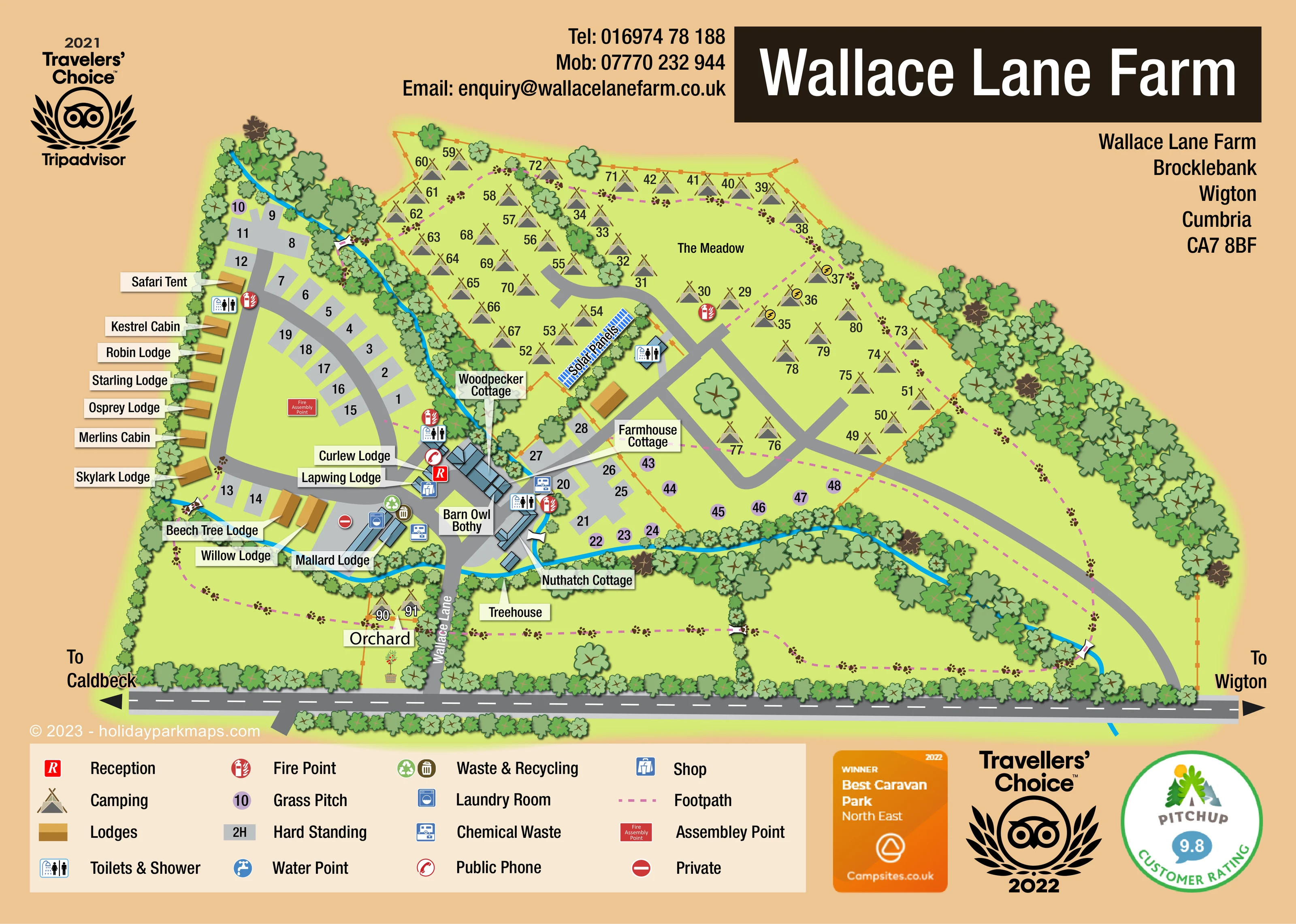
The large northern and eastern camping field is named The Meadow, with tent pitches arranged around open grass and branching access roads.
ILLUSTRATED PARK MAP · P356
Wallace Lane Farm, Brocklebank, Wigton, Cumbria · United Kingdom
 Enlarge the map ↗
A SENSE OF THE PLACE
Wallace Lane Farm offers camping, touring and self-catering accommodation at Brocklebank in Cumbria. Lodges and glamping accommodation provide alternatives to bringing a caravan or tent.
The site provides a shop, laundry, washing facilities and space for walking dogs, with fire pits available to hire. Selected accommodation includes a hot tub, while the map helps guests find the different accommodation and service areas.
LOOK CLOSER
The large northern and eastern camping field is named The Meadow, with tent pitches arranged around open grass and branching access roads.
A small named camping pocket lies west of Wallace Lane near the southern boundary, accompanied by a fruit-tree illustration.
A bright blue watercourse descends from the upper-left boundary, passes the central buildings and curves towards the lower-right edge. Small white crossing symbols connect paths across it.
Dense stylised trees define the perimeter, stream banks and internal divisions. Orange fence lines distinguish parts of the meadow and orchard.
A red R marker identifies reception at the central building cluster, close to the internal road junction.
A blue shopping-bag symbol places the shop beside reception.
Repeated blue-and-white amenity symbols serve the western accommodation area, central buildings and meadow-side service building.
A washing-machine symbol marks the laundry in the building group south-west of reception.
A red R marker identifies reception at the central building cluster, close to the internal road junction.
A blue shopping-bag symbol places the shop beside reception.
Repeated blue-and-white amenity symbols serve the western accommodation area, central buildings and meadow-side service building.
A washing-machine symbol marks the laundry in the building group south-west of reception.
Paired recycling and bin symbols identify a service location near the laundry and central road loop.
Blue disposal symbols appear near the central service buildings and adjacent touring pitches.
A red handset symbol is positioned beside reception.
Red circular extinguisher symbols are distributed between the western pitches, central buildings and meadow camping area.
A labelled red assembly-point sign is shown in the open grass within the western accommodation loop.
The key includes a blue tap symbol for water points; no individual position is clearly identifiable in the plan.
A conspicuous blue panel array is labelled diagonally beside the meadow-side amenity building.
The large northern and eastern camping field is named The Meadow, with tent pitches arranged around open grass and branching access roads.
A small named camping pocket lies west of Wallace Lane near the southern boundary, accompanied by a fruit-tree illustration.
A bright blue watercourse descends from the upper-left boundary, passes the central buildings and curves towards the lower-right edge. Small white crossing symbols connect paths across it.
Dense stylised trees define the perimeter, stream banks and internal divisions. Orange fence lines distinguish parts of the meadow and orchard.
Pink dashed paths link the camping fields and southern open ground, with brown paw-print motifs emphasising walking routes.
Wallace Lane leads from the road along the bottom of the page to the central buildings. Direction arrows identify Caldbeck to the left and Wigton to the right.
Broad grey roads form a western accommodation loop, branch through The Meadow and connect to a curved eastern access route.
A red no-entry-style symbol identifies a private area beside the laundry-side buildings.
READING THE MAP
This illustrated map of Wallace Lane Farm brings together camping, touring and individually named self-catering accommodation in a rural setting at Brocklebank, near Wigton in Cumbria. Rather than treating the site as a uniform grid of pitches, the design makes its different spaces easy to recognise: a western loop of touring pitches and lodges, the larger camping field called The Meadow, and a small Orchard area near the entrance.
A bright blue, tree-lined watercourse runs through the drawing, helping to explain how the accommodation areas relate to the central farm buildings. Reception, the shop and practical guest facilities are picked out with coloured symbols, while cream callout labels identify cottages, cabins, a bothy, a safari tent and a treehouse. Pink dashed footpaths, decorated with paw prints, add another layer of navigation through the open grounds.
The finished page combines this detailed guest plan with a prominent park title, arrival directions, contact information and a substantial symbol key. It is a useful example of mapping a varied countryside campsite without losing the character of its landscape or the individuality of its accommodation.
The plan is organised around the central farm-building group, reached by Wallace Lane from the road running along the bottom of the page. Arrows point towards Caldbeck and Wigton, giving the visitor a simple external orientation. From the central junction, broad grey roads form a loop through the western accommodation area and branch into The Meadow, with a longer curve extending down the eastern side.
On the west, hard-standing pitches sit beside the road and named gold-coloured lodge and cabin symbols follow the tree-lined boundary. These include Skylark, Robin, Starling and Osprey lodges, together with Merlins and Kestrel cabins. Willow, Beech Tree and Mallard lodges occupy the lower part of this area. Cream labels and tapered leaders identify Curlew and Lapwing lodges, Woodpecker, Farmhouse and Nuthatch cottages, Barn Owl Bothy and the Treehouse around the central buildings and stream.
The Meadow occupies the upper and right-hand fields. Numbered tent symbols are arranged along boundaries and internal rows, leaving recognisable open grass between them. Purple circles distinguish grass pitches near the watercourse, while a small pair of camping symbols marks the Orchard south-west of the buildings. The Safari Tent has its own label on the western edge.
Reception and the shop are marked together near the hub. Other symbols locate toilets and showers, laundry, waste and recycling, chemical waste disposal, a public phone and fire points. A red assembly-point sign sits within the western loop, and a blue solar-panel array is labelled beside a meadow amenity building. Pink dashed paths and paw prints weave through the fields and across small stream crossings. A wide lower legend explains the graphic system; the surrounding title, address and award panels complete the single-page composition.
KEEP EXPLORING
Chosen for shared landscapes, accommodation or facilities.
 Explore the map ↗
United Kingdom
Woodland park map with mixed pitches, bell tents, lodges and a fishing lake.
 Explore the map ↗
United Kingdom
Illustrated farm campsite map with touring pitches, pods, camping fields and a riverside dog-walk route.
 Explore the map ↗
United Kingdom
A woodland estate park map combining caravan loops, touring pitches, riverside paths and Bruce’s Cave landmarks.
Features may come from the sample artwork, its key or published park information. Approximate numbers describe the drawing and may cover only part of a park. They are intended to help you compare map examples. Current facilities and booking information should be checked with the park.
LET’S MAP YOUR PARK
For a map quotation, find your park and draw a rough boundary around it. The area you select helps us work out the design time and price.
Draw your park for a quote ↗Or talk to our map designers
01751 473136