
Dog Friendly Beach
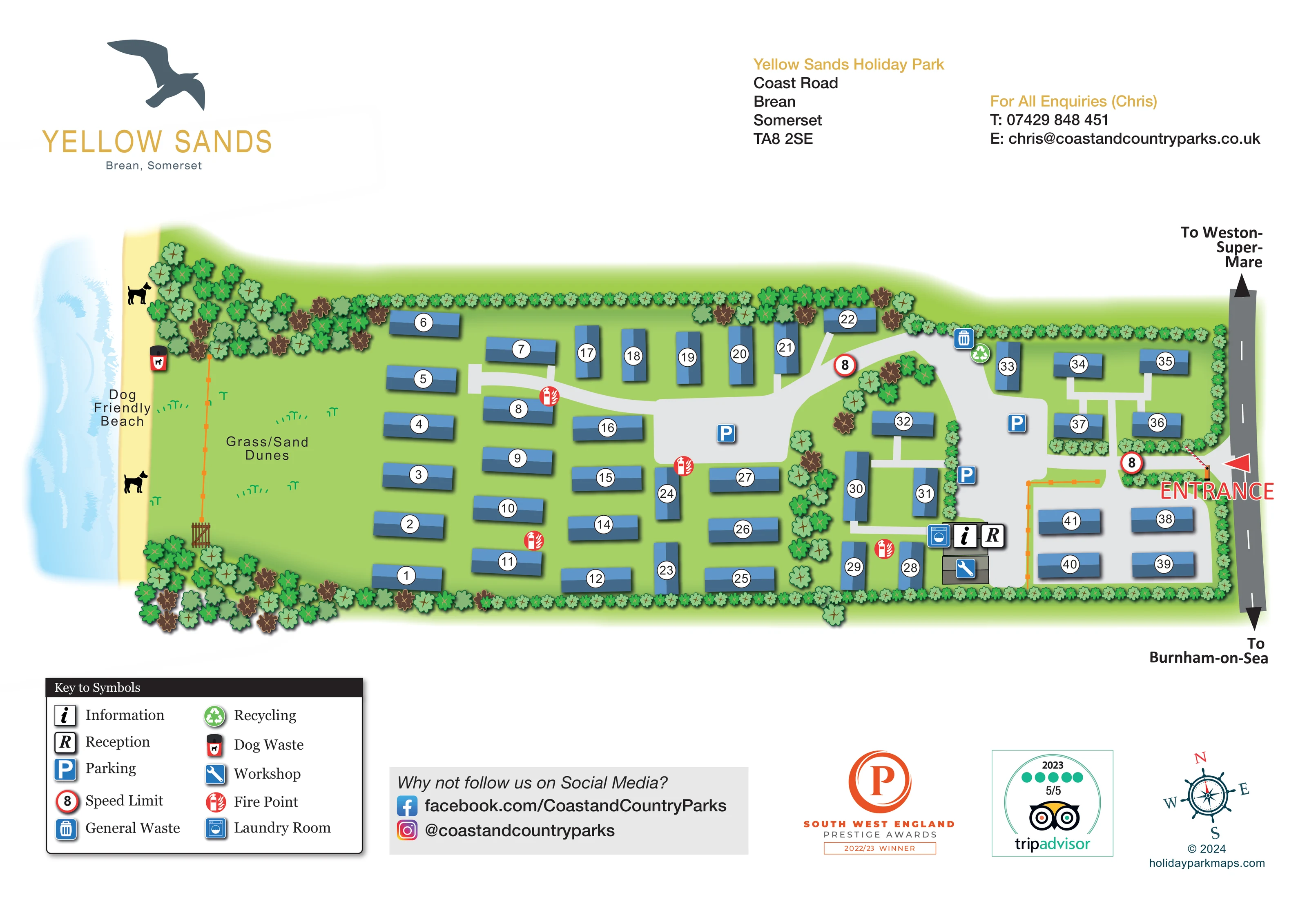
The western beach strip is explicitly labelled Dog Friendly Beach and illustrated with dog silhouettes. This label does not establish a park-wide pet policy.
ILLUSTRATED PARK MAP · P383
Yellow Sands Holiday Park, Coast Road, Brean, Somerset · United Kingdom
 Enlarge the map ↗
A SENSE OF THE PLACE
Yellow Sands Holiday Park is based at Coast Road, Brean, Somerset. The site is located behind the dunes at Brean Sands, with its own access to the seven-mile beach. The park offers privately owned holiday caravans and lodges in an owners-only setting.
The park provides security cameras and coded vehicle barriers.
LOOK CLOSER
The western beach strip is explicitly labelled Dog Friendly Beach and illustrated with dog silhouettes. This label does not establish a park-wide pet policy.
A broad green area between the accommodation and beach is labelled Grass/Sand Dunes, with scattered grass marks.
A narrow yellow beach and soft blue water strip with white wave marks establish the coastal setting on the left.
Continuous small tree and shrub symbols enclose much of the site, with denser planting at the dune-side corners and internal planted divisions.
Adjacent reception and information symbols mark the service-building cluster in the lower-right part of the park.
A washing-machine symbol identifies the laundry beside reception and information.
A spanner symbol identifies the workshop in the same service cluster.
Blue parking symbols appear on the central paved area and within the eastern road network.
Adjacent reception and information symbols mark the service-building cluster in the lower-right part of the park.
A washing-machine symbol identifies the laundry beside reception and information.
A spanner symbol identifies the workshop in the same service cluster.
Blue parking symbols appear on the central paved area and within the eastern road network.
General-waste and recycling symbols are grouped near the northern edge of the eastern accommodation area.
A dog-waste bin symbol is positioned on the western side, beside the beach and dune area.
Repeated red fire-point symbols are distributed through the accommodation rows and near the service buildings.
Red-ringed signs displaying 8 appear near the entrance and farther along the internal road. The legend calls these speed-limit symbols without specifying a unit.
A large red ENTRANCE label and arrow identify the access from the road along the eastern boundary.
Light-grey roads connect the entrance, eastern groups and broad central parking area, with short pale approaches to individual units.
The eastern road is labelled towards Weston-super-Mare at the top and Burnham-on-Sea at the bottom.
The western beach strip is explicitly labelled Dog Friendly Beach and illustrated with dog silhouettes. This label does not establish a park-wide pet policy.
A broad green area between the accommodation and beach is labelled Grass/Sand Dunes, with scattered grass marks.
A narrow yellow beach and soft blue water strip with white wave marks establish the coastal setting on the left.
Continuous small tree and shrub symbols enclose much of the site, with denser planting at the dune-side corners and internal planted divisions.
The park information identifies its own beach access. The artwork includes a gate and orange boundary line beside the dunes, but does not label a dedicated beach-access route.
The park information describes coded vehicle barriers and security cameras. These are not explicitly identified by the map's symbol key.
READING THE MAP
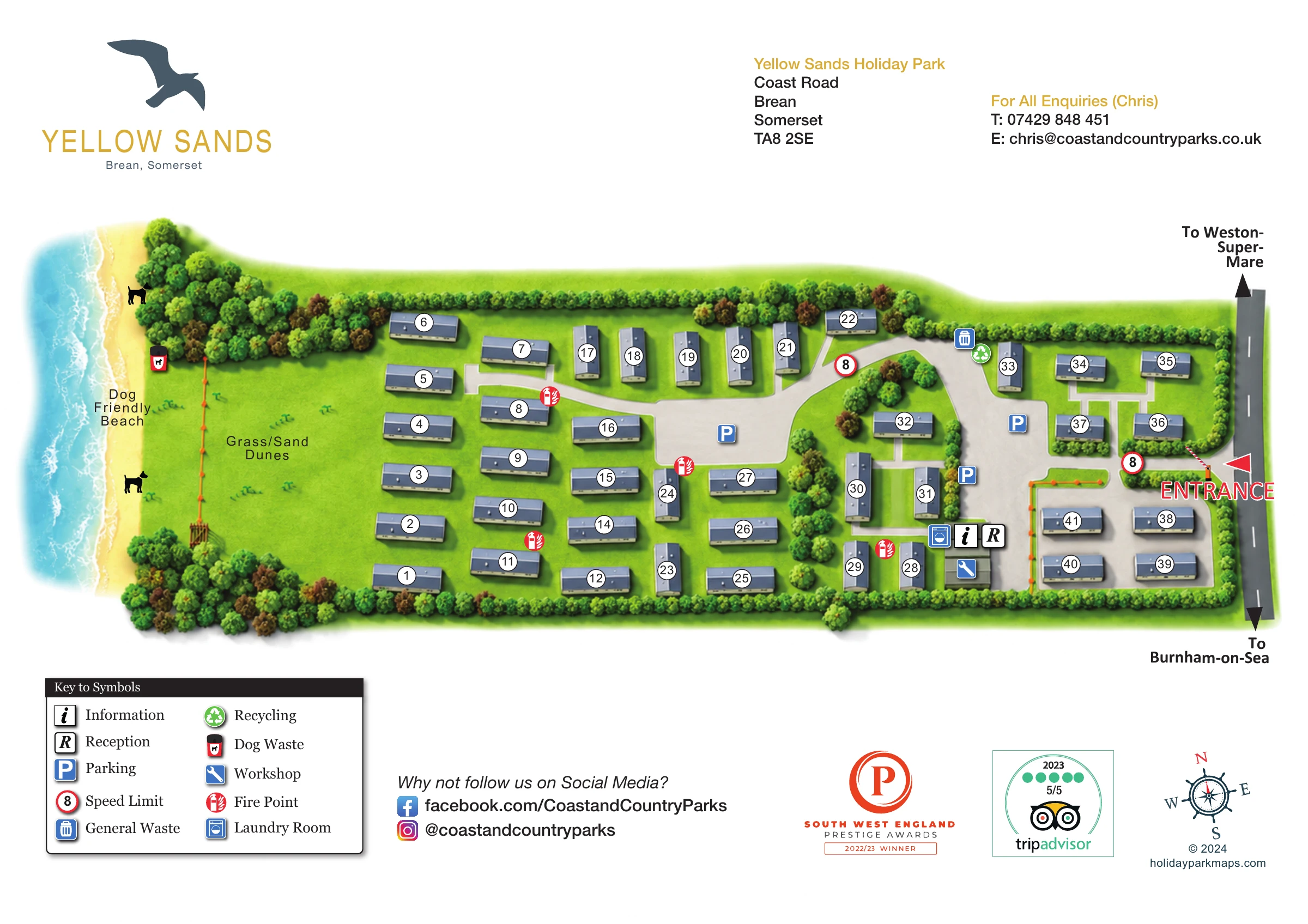
Yellow Sands Holiday Park sits behind the dunes at Brean in Somerset, and this illustrated map makes that coastal relationship the centre of its composition. A pale-blue sea and narrow sandy beach run down the left-hand side, while the road entrance is clearly marked on the right. Between them, numbered blue holiday-home blocks sit within green grounds edged by trees and shrubs.
The plan depicts a compact park of roughly 40 units, using a consistent visual language rather than separate illustrations for each accommodation type. Light-grey roads, prominent parking symbols and a clustered reception and service area help readers understand how the site fits together. The beach is labelled as dog friendly, and the broad dune area provides a distinctive landscape landmark.
Set within a spacious white page, the artwork combines practical navigation with Yellow Sands branding, contact information and a concise symbol key. It is a useful sample for coastal holiday-home parks that need to show individual units clearly while retaining the character of their seaside setting.
The map is arranged as a long coastal strip, with water and beach at the western edge and the public road at the eastern edge. A large green area labelled Grass/Sand Dunes separates the shore from the accommodation. Repeated foliage symbols form a mostly continuous perimeter, becoming denser around the dune-side corners and along internal divisions.
Blue rectangular holiday-home blocks are placed in loose rows across the western and central grounds, then in smaller, more tightly organised groups towards the entrance. Each has a white circular number badge, and the blocks rotate to follow their position within the layout. Pale approaches link many units to the light-grey road system. The eastern entrance is emphasised by a red arrow and large red lettering; the adjacent road carries directions towards Weston-super-Mare and Burnham-on-Sea.
A broad central paved area and smaller eastern spaces carry blue parking symbols. Reception and information are grouped with the laundry room and workshop near the lower-right part of the plan. General waste and recycling are marked near the northern side of the eastern accommodation area, while a dog-waste point sits beside the beach-side grounds. Red fire-point symbols recur across the site, and red-ringed speed-limit markers display 8.
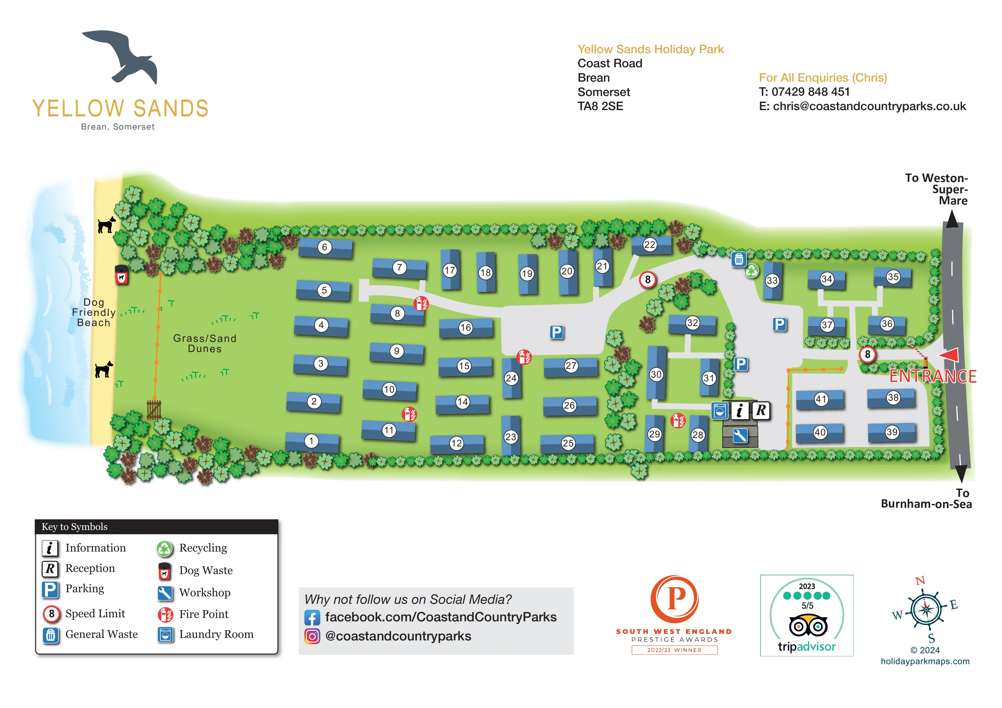
The lower-left key explains these symbols in two columns. Across the rest of the footer are a social-media panel, dated award and review badges, a nautical compass and the designer credit. Above the plan, the gull logo and gold park name balance the address and enquiry details. The accompanying enlarged views show this same footer more clearly; they are not separate maps or additional park sections.
 Enlarge this map ↗
KEEP EXPLORING
Chosen for shared landscapes, accommodation or facilities.
 Explore the map ↗
United Kingdom
Illustrated coastal holiday-home plan with dense alphanumeric plot labels, orange-roofed amenities, a numbered facility key and beach-side context.
 Explore the map ↗
United Kingdom
A colour-zoned coastal park map with touring areas, woodland trails, ponds and a leisure club.
 Explore the map ↗
United Kingdom
Colour-coded accommodation, central leisure facilities and coastal paths on an illustrated headland park map.
Features may come from the sample artwork, its key or published park information. Approximate numbers describe the drawing and may cover only part of a park. They are intended to help you compare map examples. Current facilities and booking information should be checked with the park.
TAKE A CLOSER LOOK
View the illustrated map in detail or choose a file to download. These are sample maps; contact the park for current visitor information.


LET’S MAP YOUR PARK
For a map quotation, find your park and draw a rough boundary around it. The area you select helps us work out the design time and price.
Draw your park for a quote ↗Or talk to our map designers
01751 473136
 yellowsands_large.png