
Eel Beck
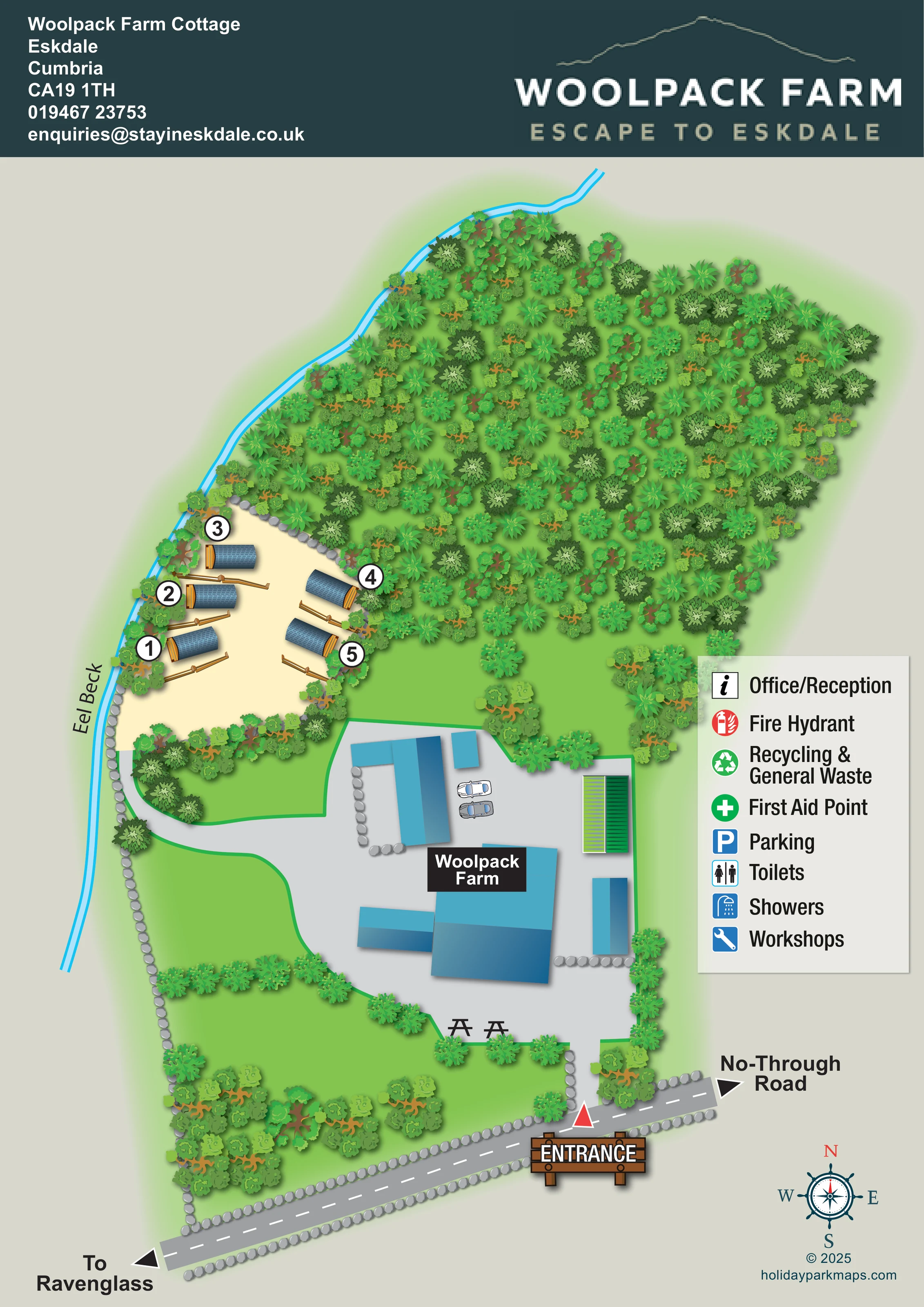
Named watercourse tracing the western edge of the site and curving around the upper woodland.
ILLUSTRATED PARK MAP · P380
Woolpack Farm Cottage, Eskdale, Cumbria · United Kingdom
 Enlarge the map ↗
A SENSE OF THE PLACE
Woolpack Farm offers glamping accommodation in the Eskdale Valley in the western Lake District. Woodland lodges and pods provide self-contained places to stay within the valley landscape.
Accommodation includes shower rooms, kitchen facilities and outdoor space, with hot-tub options available. Walks lead into the surrounding countryside, and the Ravenglass and Eskdale Railway provides another way to explore the valley.
LOOK CLOSER
Named watercourse tracing the western edge of the site and curving around the upper woodland.
Dense illustrated woodland dominates the northern part of the plan, with trees and shrubs enclosing the accommodation clearing and farm grounds.
Repeated grey stones delineate the roadside, stream-side boundary and parts of the farmyard.
A labelled group of blue-roofed buildings occupies a broad grey courtyard below the glamping clearing; individual building uses are not assigned.
Cars are illustrated beside the farm buildings, indicating parking within the yard without marking its capacity or a separate parking zone.
Two picnic-table silhouettes appear at the southern edge of the courtyard beside planting.
A timber-style ENTRANCE sign and red triangular marker identify the access from the road along the bottom of the map.
A grey route curves west from the farm courtyard and then north into the pod clearing beside the beck.
Named watercourse tracing the western edge of the site and curving around the upper woodland.
Dense illustrated woodland dominates the northern part of the plan, with trees and shrubs enclosing the accommodation clearing and farm grounds.
Repeated grey stones delineate the roadside, stream-side boundary and parts of the farmyard.
A labelled group of blue-roofed buildings occupies a broad grey courtyard below the glamping clearing; individual building uses are not assigned.
Cars are illustrated beside the farm buildings, indicating parking within the yard without marking its capacity or a separate parking zone.
Two picnic-table silhouettes appear at the southern edge of the courtyard beside planting.
A timber-style ENTRANCE sign and red triangular marker identify the access from the road along the bottom of the map.
A grey route curves west from the farm courtyard and then north into the pod clearing beside the beck.
A left-pointing road arrow is labelled 'To Ravenglass'; the destination is outside the depicted site.
The opposite end of the frontage road is labelled 'No-Through Road'.
Included in the key with an information symbol; no corresponding location marker is visible on the plan.
Listed with a red fire symbol in the key, without a visible position marker.
A green recycling symbol explains this entry in the key; the disposal point is not visibly located.
Listed with a green cross, but not assigned a visible position on the site.
A blue P appears in the key. The plan separately depicts cars in the courtyard, but does not place this symbol there.
Separate toilet and shower symbols appear in the key; neither is visibly positioned on a building.
A blue spanner symbol and Workshops label are included in the key without a mapped location.
READING THE MAP
This illustrated map of Woolpack Farm in Eskdale, Cumbria, presents a small glamping retreat through its woodland setting and working-farm layout. Rather than filling the page with accommodation rows, the design gives generous space to trees, planted boundaries and Eel Beck, which runs beside the pod clearing. Approximately five curved-roof pods form an easily understood group above the main farm courtyard.
Visitors can follow the entrance from the roadside into the yard, then trace the curving internal route towards their numbered accommodation. The road arrows distinguish the direction to Ravenglass from the no-through-road end, while a compass provides a further orientation cue. Farm buildings, illustrated cars and picnic tables help establish the character of the arrival area.
The portrait page combines this pictorial plan with a dark-teal branded header and a prominent facility key. It is a useful example for a small rural accommodation business needing a map that explains arrival and unit locations while retaining the landscape as a central part of its identity.
The single portrait plan places Woolpack Farm’s entrance along a diagonal road at the foot of the page. A timber-style entrance sign and red marker draw attention to the access into the grey farm courtyard. The road is edged with illustrated stones and carries arrows labelled 'To Ravenglass' on the left and 'No-Through Road' on the right.
Above the entrance, blue-roofed farm buildings surround an open yard. Cars appear beside the northern building group, and two picnic-table silhouettes sit near the planted southern edge. A large black label identifies Woolpack Farm without assigning individual functions to the surrounding buildings. From this courtyard, a grey route curves left and continues north into the accommodation clearing.
The pale-cream clearing contains approximately five pod-style units, arranged on opposing sides and identified by large circular numbers. Curved, textured roofs and timber-coloured ends distinguish them from the angular farm buildings. Short fence sections mark the pod frontages, while trees and stones enclose the clearing. Eel Beck follows its western side and continues around the extensive woodland above.
A pale key on the right lists office/reception, fire hydrant, recycling and general waste, first aid, parking, toilets, showers and workshops. These are key entries rather than visibly positioned facility markers. The lower-right compass completes the orientation information, while the dark-teal header carries the farm branding and contact details. The enlarged detail views show overlapping portions of this same artwork, not additional site sections or accommodation.
KEEP EXPLORING
Chosen for shared landscapes, accommodation or facilities.
 Explore the map ↗
United Kingdom
Illustrated lakeside pod map with woodland arrival routes, named lodges and a waterside circuit.
 Explore the map ↗
United Kingdom
Woodland park map with mixed pitches, bell tents, lodges and a fishing lake.
 Explore the map ↗
United Kingdom
Colour-coded accommodation, lakeside facilities and woodland routes at Burton Constable Holiday Park & Arboretum.
Features may come from the sample artwork, its key or published park information. Approximate numbers describe the drawing and may cover only part of a park. They are intended to help you compare map examples. Current facilities and booking information should be checked with the park.
LET’S MAP YOUR PARK
For a map quotation, find your park and draw a rough boundary around it. The area you select helps us work out the design time and price.
Draw your park for a quote ↗Or talk to our map designers
01751 473136