
Woodyhyde Woodlands
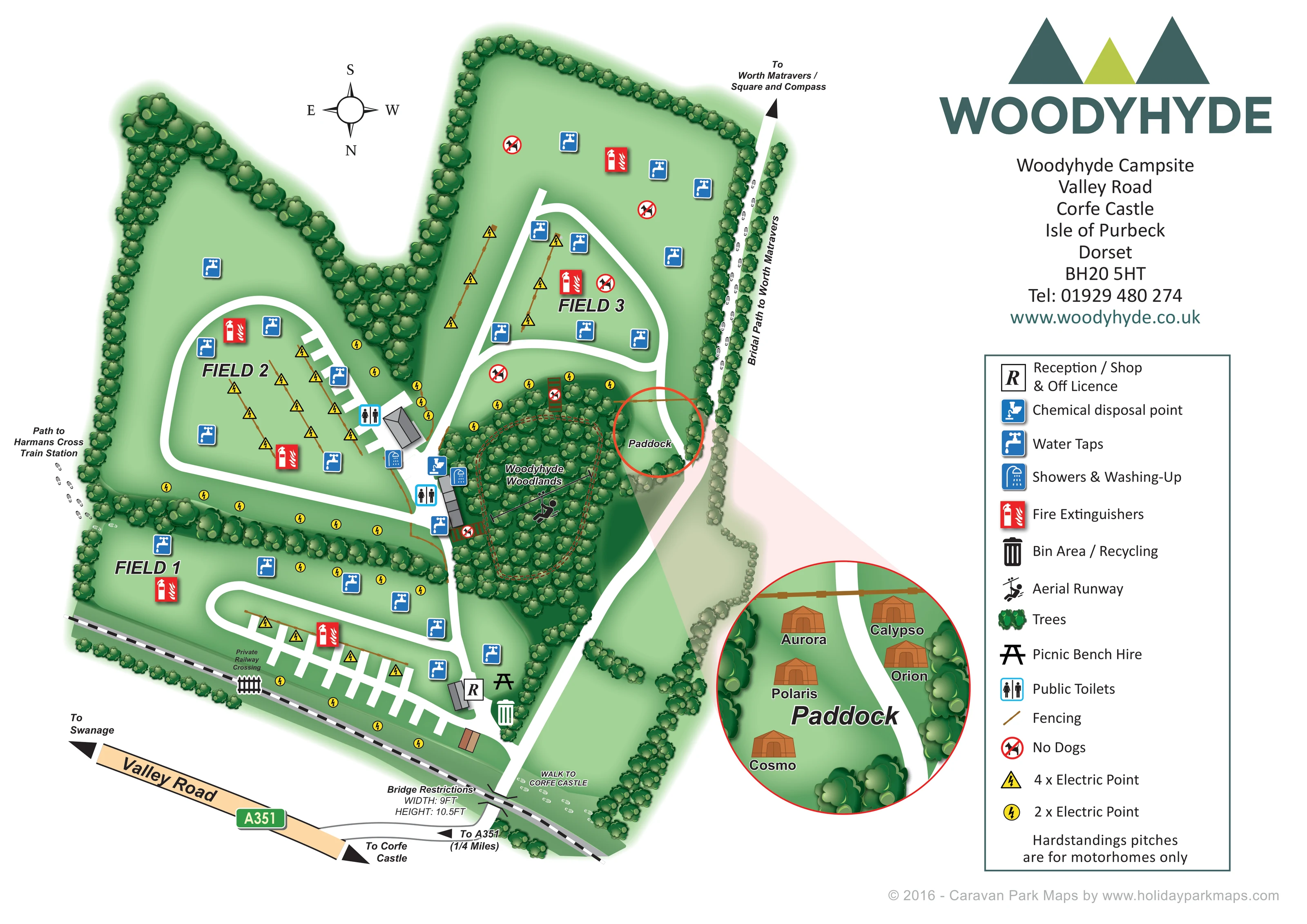
A dense central-right woodland wedge includes a dashed brown loop and the aerial runway.
ILLUSTRATED PARK MAP · P652
Woodyhyde Campsite, Valley Road, Corfe Castle, Isle of Purbeck, Dorset · United Kingdom
 Enlarge the map ↗
A SENSE OF THE PLACE
Woodyhyde is a family-run campsite near Corfe Castle on the Isle of Purbeck in Dorset. Open countryside and spacious unmarked pitches give the site a relaxed camping character.
Tents and motorhomes are welcomed, while yurts and shepherd's huts provide prepared accommodation. Dog-friendly stays and access to Swanage, Studland and the Jurassic Coast add to its appeal as a base for exploring Purbeck.
LOOK CLOSER
A dense central-right woodland wedge includes a dashed brown loop and the aerial runway.
Continuous illustrated tree belts enclose and divide the fields. Brown fence lines structure electric-point rows and the Paddock boundary.
A small area beside Field 3 and the woodland is linked to a circular enlargement showing five named glamping units.
An R marker identifies a small building beside the entrance-side road in Field 1; the legend explains its combined functions.
Two clusters of toilet and shower/washing-up symbols accompany grey service buildings between Field 2 and Woodyhyde Woodlands.
Blue tap symbols are distributed across all three fields and near the central facilities.
A blue disposal symbol marks the central service area beside the woodland.
Yellow triangular and circular symbols distinguish four-point and two-point electric connections, arranged along fences, field margins and hardstanding rows.
An R marker identifies a small building beside the entrance-side road in Field 1; the legend explains its combined functions.
Two clusters of toilet and shower/washing-up symbols accompany grey service buildings between Field 2 and Woodyhyde Woodlands.
Blue tap symbols are distributed across all three fields and near the central facilities.
A blue disposal symbol marks the central service area beside the woodland.
Yellow triangular and circular symbols distinguish four-point and two-point electric connections, arranged along fences, field margins and hardstanding rows.
Repeated red extinguisher symbols mark locations in each camping field.
A large bin symbol appears beside the entrance-side junction near reception.
A picnic-table symbol near reception corresponds to the legend entry for bench hire.
A prominent rider-and-cable illustration locates the aerial runway within Woodyhyde Woodlands.
A dense central-right woodland wedge includes a dashed brown loop and the aerial runway.
Continuous illustrated tree belts enclose and divide the fields. Brown fence lines structure electric-point rows and the Paddock boundary.
A small area beside Field 3 and the woodland is linked to a circular enlargement showing five named glamping units.
Crossed-out dog symbols appear in Field 3 and at woodland access points. These describe restrictions represented in the artwork, not a current park-wide pet policy.
Broad white roads connect the entrance, reception, facilities and three fields, with looped sections and short hardstanding spurs.
The lower edge shows Valley Road, an A351 road badge, an approach link and directional arrows towards Swanage and Corfe Castle.
A black-and-white railway runs along the lower campsite boundary. A private railway crossing is labelled in Field 1, and bridge width and height restrictions are annotated at the entrance approach.
Footprint symbols lead out from the left side of the campsite towards the named station.
A footprint-marked walking connection is labelled near the entrance and railway.
A tree-lined route follows the right edge of Field 3, labelled 'Bridal Path to Worth Matravers', with an arrow towards Worth Matravers and the Square and Compass.
READING THE MAP
This illustrated map of Woodyhyde Campsite brings together open camping fields, motorhome hardstandings and a small glamping paddock in the countryside near Corfe Castle, Dorset. Rather than filling the site with numbered tent pitches, the artwork uses three clearly labelled fields, tree-lined boundaries and broad white access roads to explain how the campsite fits together.
Woodyhyde Woodlands forms a distinctive green centrepiece, with an aerial runway illustrated among the trees. Around it, recognisable symbols locate toilets, showers, washing-up facilities, water taps and electric connection points. Reception, the shop and off licence sit towards the entrance, close to the recycling and picnic-bench-hire markers.
A circular enlargement gives the Paddock its own space, showing five named glamping units without crowding the main plan. The railway, Valley Road approach and walking links towards Corfe Castle, Harmans Cross Train Station and Worth Matravers extend the map beyond the campsite boundary. A large branded information column and full symbol key complete a design suited to a rural campsite with several different ways to stay.
The main plan presents Woodyhyde as three irregular grass fields enclosed and separated by illustrated tree belts. Field 1 lies alongside the railway at the bottom of the page, Field 2 occupies the left-hand lobe, and Field 3 extends upwards on the right. The compass makes the unusual south-up orientation explicit. Wide white roads connect these areas through curved loops and branching junctions, while rectangular bays distinguish the motorhome hardstandings in Fields 1 and 2.
Near the entrance, an R symbol identifies reception, the shop and off licence. Bin/recycling and picnic-bench-hire markers sit nearby. Further into the campsite, grey-roofed buildings and blue symbols locate the toilet, shower and washing-up facilities, together with chemical disposal. Water taps, red fire-extinguisher markers and two different yellow electric-point symbols are distributed through the fields. Brown fence lines provide additional structure, particularly beside electric connections.
Woodyhyde Woodlands is drawn as a dense wedge of rounded tree crowns, containing a dashed loop and a large aerial-runway illustration. Beside it, a red circle picks out the Paddock on the main plan. A translucent pink link leads to a larger circular inset, where orange-brown glamping units are named Aurora, Calypso, Orion, Polaris and Cosmo.
The lower boundary includes the railway, a labelled private crossing and bridge-restriction annotations at the approach. Valley Road and the A351 are shown with arrows towards Swanage and Corfe Castle. Footprints identify walking connections, including the route to Harmans Cross Train Station and the tree-lined path towards Worth Matravers. The right-hand column balances the detailed plan with prominent branding, contact information and a comprehensive legend.
KEEP EXPLORING
Chosen for shared landscapes, accommodation or facilities.
 Explore the map ↗
United Kingdom
Woodland park map with mixed pitches, bell tents, lodges and a fishing lake.
 Explore the map ↗
United Kingdom
Woodland holiday-park map with named accommodation areas, touring loops and illustrated recreation facilities.
 Explore the map ↗
United Kingdom
Mixed-accommodation park map with woodland, public footpaths and clearly differentiated service symbols.
Features may come from the sample artwork, its key or published park information. Approximate numbers describe the drawing and may cover only part of a park. They are intended to help you compare map examples. Current facilities and booking information should be checked with the park.
TAKE A CLOSER LOOK
View the illustrated map in detail or choose a file to download. These are sample maps; contact the park for current visitor information.


LET’S MAP YOUR PARK
For a map quotation, find your park and draw a rough boundary around it. The area you select helps us work out the design time and price.
Draw your park for a quote ↗Or talk to our map designers
01751 473136