
Canal and narrow watercourse
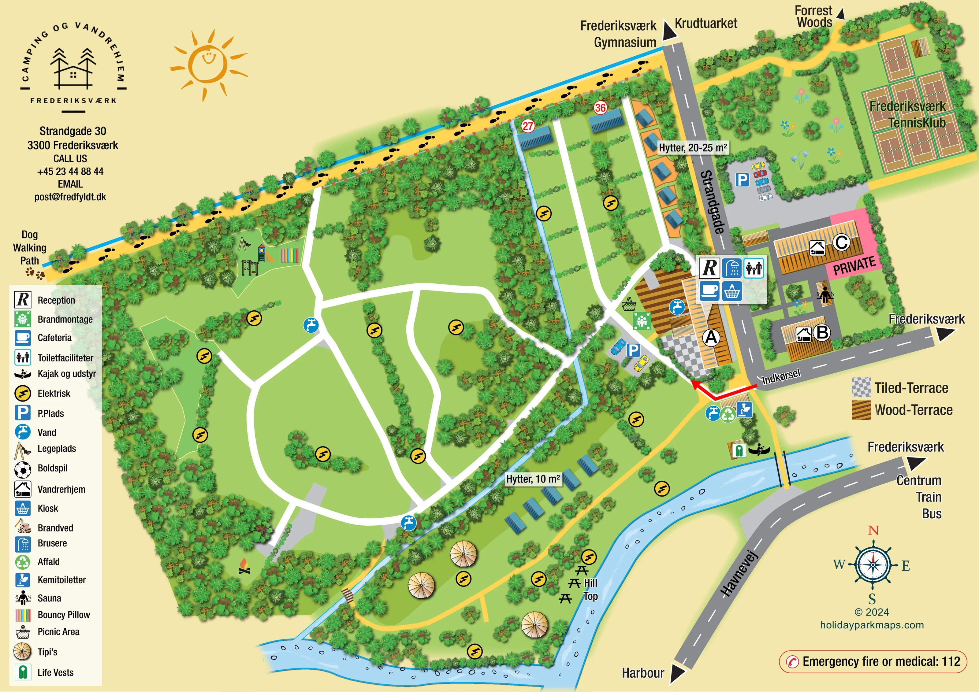
A broad blue canal wraps around the lower and right-hand lawns. A narrower blue channel separates the main camping ground from the cabin and tipi strip.
ILLUSTRATED PARK MAP · P128
Strandgade 30, Frederiksværk · Denmark
 Enlarge the map ↗
A SENSE OF THE PLACE
Frederiksværk Camping and Hostel is based at Strandgade 30, Frederiksværk. The site is beside the canal in central Frederiksværk, close to the pedestrian shopping street. The park provides 100 touring/tent pitches, 12 cabins and 30 hostel rooms.
Canoe and kayak hire operates on the canal with routes toward Arresø and Roskilde Fjord. Communal kitchen and bathrooms, Wi-Fi and parking are available.
LOOK CLOSER
A broad blue canal wraps around the lower and right-hand lawns. A narrower blue channel separates the main camping ground from the cabin and tipi strip.
Dense illustrated trees enclose much of the site, while shorter hedge runs subdivide the grass areas.
A named waterside location is shown beside picnic tables on the lower-right lawn.
A labelled group of tennis courts is illustrated across Strandgade as a neighbouring landmark, not as a confirmed park-operated facility.
A prominent R symbol identifies reception at the main building A beside the entrance.
Cup and shopping-basket symbols are grouped with reception at the main service building.
Toilet and shower symbols identify facilities at the reception building.
Repeated blue tap symbols mark water points around the grass areas, main building and entrance-side service area.
A prominent R symbol identifies reception at the main building A beside the entrance.
Cup and shopping-basket symbols are grouped with reception at the main service building.
Toilet and shower symbols identify facilities at the reception building.
Repeated blue tap symbols mark water points around the grass areas, main building and entrance-side service area.
Yellow circles with black lightning symbols are distributed across the main camping ground and waterside lawns.
Waste and chemical toilet symbols are grouped beside a water point just inside the entrance, towards the canal.
Parking is marked beside building A and across Strandgade near the hostel and tennis club.
Swings, climbing equipment and a slide are illustrated within a grass enclosure near the upper-left woodland edge.
A brightly striped bouncy pillow is drawn alongside the playground equipment.
A picnic-basket symbol marks an area beside the main wooden terrace; picnic-table symbols also appear beside the canal at Hill Top.
A sauna symbol appears on a small structure between hostel buildings B and C.
A paddler symbol marks the canal bank beside the pedestrian bridge.
A green life-vest symbol is placed beside the kayak equipment location.
A green assembly-point symbol is shown beside the main building's terrace.
Brown striped decking and grey chequered paving distinguish terrace surfaces, with a separate two-item key.
A flame over crossed logs marks a location near the lower-left edge of the main camping ground.
A football symbol appears in the legend, but no corresponding location is clearly identifiable on the plan.
An axe-and-logs symbol is listed in the legend; a matching mapped location is not clearly visible.
A broad blue canal wraps around the lower and right-hand lawns. A narrower blue channel separates the main camping ground from the cabin and tipi strip.
Dense illustrated trees enclose much of the site, while shorter hedge runs subdivide the grass areas.
A named waterside location is shown beside picnic tables on the lower-right lawn.
The long upper boundary path is explicitly labelled for dog walking and illustrated with footprints and paw marks.
A strong red arrow labelled Indkørsel leads from Strandgade into the site beside building A.
White looping routes serve the main grass areas. Yellow paths follow the waterside lawns, with small bridges across the narrow channel and the canal.
External arrows indicate Frederiksværk, the centre, train and bus connections, and the harbour via Havnevej.
Upper-edge arrows reference woods, Frederiksværk Gymnasium and Krudtuarket, using the wording printed on the artwork.
A labelled group of tennis courts is illustrated across Strandgade as a neighbouring landmark, not as a confirmed park-operated facility.
Pink highlighting and a PRIVATE label identify part of the area around hostel building C.
Operator information mentions a communal kitchen and Wi-Fi; these are not individually located by the illustrated map.
READING THE MAP
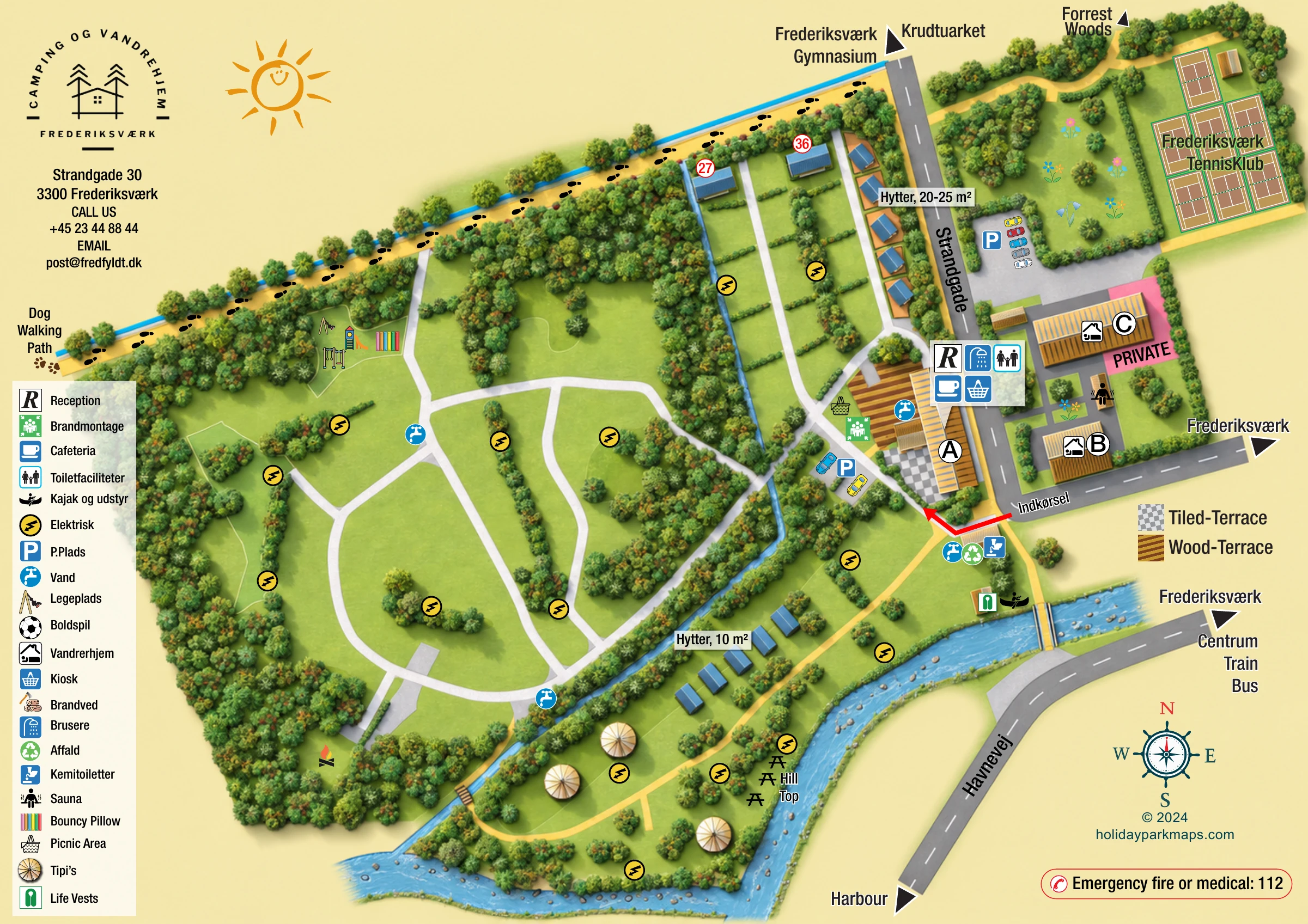
This illustrated map presents Frederiksværk Camping and Hostel as a green, canal-side retreat within the Danish town of Frederiksværk. Rather than filling the camping ground with individual pitch numbers, it shows the broader organisation of grass areas, tree belts, access loops and shared service points. That approach suits a site where visitors need to understand the grounds as well as find a particular building.
The map brings several accommodation areas into one coherent picture: blue-roofed cabins beside Strandgade and the watercourse, hostel buildings across the street, and a small group of tipis on the lower lawn. Reception, the cafeteria, kiosk, showers and toilets form an easily recognised arrival hub, while the playground, bouncy pillow, sauna and waterside picnic spots give the plan useful everyday detail.
A footprint-marked dog walking path, canal bridges and outward directions to the town centre, transport and harbour extend its purpose beyond basic check-in navigation. Dense illustrated greenery, pale blue water and a warm cream background establish the setting without obscuring the main routes.
The single landscape-format artwork combines a whole-site plan with nearby streets and landmarks. The camping ground occupies most of the left-hand side, enclosed by substantial tree belts and divided into smaller grass compartments by hedge runs. Broad white routes branch and loop through this area, with repeated electrical and water symbols showing the distribution of shared services. The playground and striped bouncy pillow sit near the upper woodland edge, below the long dog walking route marked with footprints.
Strandgade runs down the right-hand side of the camping ground. A red entrance arrow directs attention to building A, where a compact icon group identifies reception, the cafeteria, kiosk, toilets and showers. Parking, an assembly point and a picnic area are marked nearby. Chequered paving and striped brown decking distinguish the main terrace surfaces. Across the road, hostel buildings B and C are labelled with accommodation symbols, with a sauna between them and pink highlighting around a private area.
The lower grounds have a different character. Smaller cabins follow a narrow watercourse, while tipis and picnic tables occupy the lawn beside the broader canal. Yellow paths and small bridges connect these areas, and kayak equipment and life vests are marked near the canal crossing. Larger cabins are labelled beside Strandgade, with floor-area labels distinguishing the two cabin groups.
Around the perimeter, arrows point towards the harbour, town centre, train and bus connections, woods and other local landmarks. The neighbouring tennis club is drawn in detail across the street. A tall pictorial legend, terrace key, compass and emergency-number panel complete the sheet. The enlarged views reveal details of this same plan rather than separate map variants.
 Enlarge this map ↗
KEEP EXPLORING
Chosen for shared landscapes, accommodation or facilities.
 Explore the map ↗
United Kingdom
A woodland estate park map combining caravan loops, touring pitches, riverside paths and Bruce’s Cave landmarks.
 Explore the map ↗
United Kingdom
A colourful riverside park map combining touring pitches, holiday accommodation and treetop adventures.
 Explore the map ↗
United Kingdom
Illustrated farm campsite map with touring pitches, pods, camping fields and a riverside dog-walk route.
Features may come from the sample artwork, its key or published park information. Approximate numbers describe the drawing and may cover only part of a park. They are intended to help you compare map examples. Current facilities and booking information should be checked with the park.
LET’S MAP YOUR PARK
For a map quotation, find your park and draw a rough boundary around it. The area you select helps us work out the design time and price.
Draw your park for a quote ↗Or talk to our map designers
01751 473136